Yuma Area Water Management System (YAWMS) GROUNDWATER BASICS
GROUNDWATER MAPS
A groundwater map is a pictorial representation of groundwater levels for a specific area.
The Bureau of Reclamation's Yuma Area Office (YAO) produces two types of groundwater maps: depth-to-groundwater and groundwater-elevation. The first type shows the depth below ground surface of the water table, or the depth at which groundwater is encountered. The second shows the elevation (with respect to mean sea level) of the water table. Just as a topographic map uses contour lines to indicate elevations of mountains,
a groundwater map uses contour lines to indicate depth to the water table (or elevation of the water table) for a particular area. The Yuma
Area Office is continually updating these maps for the Yuma area.
To view the most current groundwater monitoring status report summarizing water level conditions in the Yuma area, click here.
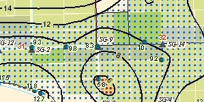
This is a small portion of the South Gila Valley groundwater map.
Black contour lines = depth to groundwater in feet
Red dots = depth to groundwater is 0' - 6'
Green dots = depth to groundwater is 6' - 12'
Select options below to view and download the most recent maps we have available for a specific area. The groundwater maps will open in a new PDF window; you will need to have Adobe Acrobat Reader (or another PDF reader) installed on your computer to view or print these maps. If you have difficulty accessing these files and would like to request hard copies, please contact the YAO Geology and Groundwater Team at (928) 343-8100.
South Gila Valley
Updated monthly
Most recent PDF version (appr. 1.72 MB)
Yuma Valley
Updated monthly
Most recent PDF version (appr. 2.02 MB)
Wellton Mohawk Valley
Updated quarterly
Most recent PDF version (appr. 2.46 MB)
Reservation Division
Updated quarterly
Most recent PDF version (appr. 2.96 MB)
Yuma Area -
This map shows groundwater levels at feet above mean sea level.
Updated semi-annually
Most recent PDF version (appr. 8.93 MB)
