Yuma Area Water Management System (YAWMS) GROUNDWATER BASICS
Groundwater is the main source of water for about half the population of the United States. In the Yuma, Arizona, area, many farms lying outside of water districts rely on groundwater for crop irrigation. Many homes located outside areas served by water utilities use groundwater for domestic purposes. But while groundwater is valuable as a source of water supply in the Yuma area, if not controlled, it can also damage agriculture, domestic septic systems, and building foundations. Providing that control in the Yuma area is a system of drainage ditches and numerous high-capacity drainage wells.
Groundwater is the water occupying the saturated zone of the subsurface. If you stand almost anywhere in Yuma (or anywhere else, for that matter), the subsurface below your feet will usually look something like what is shown in the figure below. The water table is the top surface of the saturated zone. The saturated zone is composed of aquifers and confining beds, which are ultimately underlain by bedrock (or solid rock, which generally acts as a barrier to significant groundwater flow). The aquifer in the Yuma area is generally unconfined and extends from the Gila Mountains on the east to Mexicali Valley on the west and from Laguna Dam on the north to the Gulf of California on the south.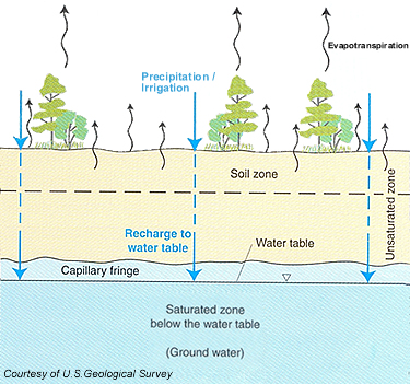
Groundwater is generally in a constant state of motion, flowing from its point of entry into the saturated zone to a place of discharge, and flowing from a point of high hydraulic head to a point of lower head.
In the Yuma area, groundwater primarily enters the saturated zone as downward percolating irrigation water, as seepage from a losing reach of the Colorado River, or from one of the many unlined irrigation canals. Water entering the saturated zone is called “recharge.”
Groundwater leaves the saturated zone as seepage to a gaining river reach or surface ditch drain, as pumpage from a well, or by evapotranspiration. Compared to river flow, groundwater moves very slowly. A velocity of 1 foot per day is relatively fast for groundwater. Rates of 1 foot per month or slower are common.
Some groundwater flows west from Yuma Valley, under the Colorado River and into Baja California, Mexico. Other groundwater flows south from Yuma Valley and Yuma Mesa into Sonora, Mexico.
Irrigation and precipitation
Irrigation water and precipitation which percolate down to the water table are common sources of recharge to the groundwater system. In the Yuma area, the primary source of groundwater recharge is irrigation. Another significant source is seepage from unlined canals and from the Colorado and Gila rivers, particularly in times of high flows. On the other hand, precipitation, which averages only about 3 inches per year in the Yuma area, is almost entirely evaporated before penetrating to the water table and consequently makes a virtually negligible contribution to Yuma area recharge.
Evapotranspiration
Evapotranspiration is the loss of water to the atmosphere from a land area by transpiration of plants and/or evaporation from the soil and surface water bodies. In the Yuma area, the greatest evapotranspiration losses are from agricultural areas, and from riparian vegetation and open water in or near the Colorado and Gila rivers. Evapotranspiration usually removes water before it can penetrate to the water table and recharge the groundwater system (saturated zone). However, where the water table is at or very near the ground surface or where the roots of plants extend down to the water table, such as in or near the Colorado and Gila rivers, evapotranspiration removes water directly from the groundwater system.
Unsaturated zone
The unsaturated zone extends from the ground surface to the capillary fringe. In the unsaturated zone, the pores (or spaces between soil particles or spaces in fractures or openings in rock masses) are filled with water and air. Water in the unsaturated zone is under pressures less than atmospheric and is held tightly to the solid materials by capillary or surface-tension forces. Because it is held by these capillary forces, water in the unsaturated zone will not flow to a well.
Soil zone or soil-water zone
The soil zone, or soil-water zone, is part of the unsaturated zone lying just below the ground surface. The soil zone contains plant roots, voids left by decaying roots and burrowing animal life, and water (soil water) available for plant uptake.
Capillary fringe
The capillary fringe is a transitional region between the unsaturated and saturated zones. In the capillary fringe, the pores (or spaces between soil particles or spaces in fractures or openings in rock masses) are completely filled with water. This water is held in place by capillary forces and water pressures are less than atmospheric. The thickness of the capillary fringe can be more than 10 feet in fine silt and less than 1 inch in fine gravel. As in the unsaturated zone, water in the capillary fringe will not flow to a well.
Saturated zone
The saturated zone lies below the capillary fringe. In the saturated zone the pore spaces (or spaces between soil particles or spaces in fractures or openings in rock masses) are completely filled with water, and pressures in the water are greater than atmospheric. Water in the saturated zone is called groundwater. Unlike the unsaturated zone and the capillary fringe, water in the saturated zone will flow to a pumped well.
Water table
The water table is the top surface of the saturated zone. At the water table, water pressure is atmospheric. The elevation of the water table fluctuates in time due to variations, which are often seasonal, in recharge and discharge from the saturated zone. The altitude of the water table at any location is the altitude to which water will rise in a vertical pipe whose lower end is open and just penetrates the upper surface of the saturated zone, and whose upper end is open to the atmosphere.
Last Updated: 10/15/21
