Federal Columbia River Power System Biological Opinion
Tributary Habitat Program — 2012 Expert Panel Map Tools

FCRPS Home | 2012 Expert Panels | 2012 Background | 2012 Meetings | 2012 Workshops | Map Tools | 2012 Reference


Map Tools
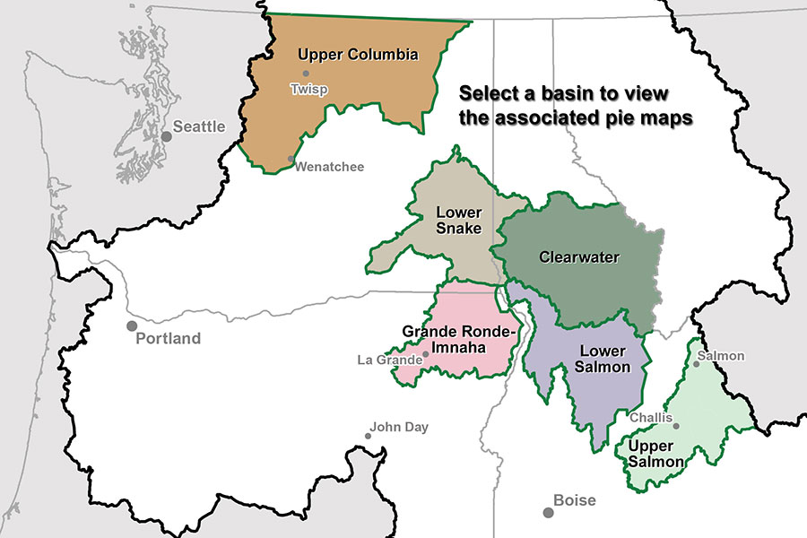
Basin map Lower Snake Pie Maps Clearwater Subbasin Pie Maps Lower Salmon Pie Maps Grande Ronde Imnaha Subbasin Pie Maps Upper Salmon Pie Maps Upper Columbia Pie Maps

Tributary habitat for each steelhead and chinook salmon population is composed of geographic areas called “assessment units”. Limiting factors that influence the survival and potential for recovery of salmon and steelhead are different among the assessment units for each population. Large numbers of limiting factor habitat functions are evaluated at expert panel workshops. These numbers have been managed in spreadsheet tables for review, assignment, calculation, and reporting purposes. Sometimes it is difficult to see the “big picture” simply by looking at all of the numbers in the spreadsheet tables.

The AAs have developed “Pie Maps” that illustrate the numerical limiting factor data in the spreadsheets using pie charts (pies) and bar graphs (bars). A pie illustrates each limiting factor in the assessment unit. Pie size is relative to the limiting factor weight, or importance of a particular limiting factor relative to other limiting factors within the assessment unit. Pie slices represent status of limiting factor habitat functions and potential through 2018 (the term of the 2008/2010 FCRPS BiOp). Bars illustrate a “roll up” of the habitat functions illustrated by the pies for the entire assessment unit. The width of the bar is proportional to the “intrinsic potential”, or importance of a particular assessment unit to life stages that occur in tributaries relative to other assessment units that comprise the salmon or steelhead population.

The AAs prepared limiting factor pie maps for the original limiting factor habitat functions that have been used to evaluate planned and completed habitat improvement actions through the end of 2012. In October, 2011, the Action Agencies received a set of standardized limiting factors and associated definitions for Pacific salmon from staff at the NOAA NWFSC. Regional State, Tribal, and local partners agreed that it would be valuable to transition from the original set of limiting factors used through the end of 2012 to the standard set of limiting factor terms and definitions for evaluating habitat improvement actions planned and completed after 2012, and regional partners began the process in earnest. Two sets of maps were prepared using the standardized set of limiting factors and definitions. The first set represents the initial transition from the original to the standardized limiting factor conditions prior to the expert panel workshop; the second set represents standardized limiting factor conditions after each expert panel evaluated changes in limiting factors associated with habitat improvement actions planned for completion by the end of 2018.


Upper Columbia Pie Maps

2012 conditions represented using Standardized NOAA Fisheries Limiting Factors
Upper Columbia Spring Chinook Population Assessment Units and Limiting Factors - Wenatchee Subbasin, Washington PDF 4.85 mb
Upper Columbia Steelhead Population Assessment Units and Limiting Factors - Wenatchee Subbasin, Washington PDF 4.8 mb
Upper Columbia Spring Chinook and Steelhead Population Assessment Units and Limiting Factors - Entiat Subbasin, Washington PDF 3.86 mb
Upper Columbia Spring Chinook Population Assessment Units and Limiting Factors - Methow Subbasin, Washington PDF 5.05 mb
Upper Columbia Steelhead Population Assessment Units and Limiting Factors - Methow Subbasin, Washington PDF 4.86 mb
Upper Columbia Steelhead Population Assessment Units and Limiting Factors - Okanogan Subbasin, Washington PDF 8.45 mb
2009 conditions represented using Original Limiting Factors
Upper Columbia Spring Chinook and Steelhead Population Assessment Units and Limiting Factors — Wenatchee Subbasin, Washington PDF 8.43 mb
Upper Columbia Spring Chinook and Steelhead Population Assessment Units and Limiting Factors — Entiat Subbasin, Washington PDF 3.56 mb
Upper Columbia Spring Chinook and Steelhead Population Assessment Units and Limiting Factors — Methow Subbasin, Washington PDF 7.33 mb
Upper Columbia Spring Chinook and Steelhead Population Assessment Units and Limiting Factors — Okanogan Subbasin, Washington PDF 4.42 mb

Lower Snake Pie Maps

2012 conditions represented using Standardized NOAA Fisheries Limiting Factors
Lower Snake River Chinook and Steelhead Population Assessment Units and Limiting Factors - Tucannon/Asotin Populations PDF 4.91
2009 conditions represented using Original Limiting Factors
Lower Snake River Chinook and Steelhead Population Assessment Units and Limiting Factors — Tucannon/Asotin Populations PDF 5.05 mb

Grande Ronde/Imnaha Pie Maps

2012 conditions represented using Standardized NOAA Fisheries Limiting Factors
Snake River Spring/Summer Chinook Population Assessment Units and Limiting Factors for the Grande Ronde/Imnaha Subbasins - Upper Grande Ronde Mainstem/Catherine Creek Populations PDF 11.09 mb
Snake River Spring/Summer Chinook Population Assessment Units and Limiting Factors for the Grande Ronde/Imnaha Subbasins - Lower Grande Ronde River/Wallowa River Populations PDF 8.75 mb
Snake River Spring/Summer Chinook Population Assessment Units and Limiting Factors for the Grande Ronde/Imnaha Subbasins - Imnaha River Population PDF 7.95 mb
Snake River Steelhead Population Assessment Units and Limiting Factors for the Grande Ronde/Imnaha Subbasins - Upper Grande Ronde River Population PDF 5.63 mb
Snake River Steelhead Population Assessment Units and Limiting Factors for the Grande Ronde/Imnaha Subbasins - Imnaha River Population PDF 7.95 mb
2009 conditions represented using Original Limiting Factors
Snake River Spring/Summer Chinook Population Assessment Units and Limiting Factors for the Grande Ronde/Imnaha Subbasins — Grande Ronde River (Upper Mainstem) Populations PDF 4.59 mb
Snake River Steelhead Population Assessment Units and Limiting Factors for the Grande Ronde/Imnaha Subbabsins — Imnaha River Populations PDF 4.57 mb
Snake River Steelhead Population Assessment Units and Limiting Factors for the Grande Ronde/Imnaha Subbasins — Joseph Creek Population PDF 4.39 mb
Snake River Steelhead Population Assessment Units and Limiting Factors for the Grande Ronde/Imnaha Subbasins — Grand Ronde River, Lower Mainstem & Tributaries Populations PDF 4.42 mb
Snake River Steelhead Population Assessment Units and Limiting Factors for the Grande Ronde/Imnaha Subbasins — Grand Ronde River, Upper Mainstem Populations PDF 7 mb
Snake River Steelhead Population Assessment Units and Limiting Factors for the Grande Ronde/Imnaha Subbasins — Wallowa River Population PDF 4.49 mb
Snake River Spring/Summer Chinook Population Assessment Units and Limiting Factors for the Grande Ronde/Imnaha Subbasins — Big Sheep Creek and Upper Imnaha River PDF 4.92 mb
Snake River Spring/Summer Chinook Population Assessment Units and Limiting Factors for the Grande Ronde/Imnaha Subbasins — Catherine Creek Populations PDF 4.47 mb
Snake River Spring/Summer Chinook Population Assessment Units and Limiting Factors for the Grande Ronde/Imnaha Subbasins — Wallowa-Lostine Rivers and Minam River Populations PDF 4.84 mb
Snake River Spring/Summer Chinook Population Assessment Units and Limiting Factors for the Grande Ronde/Imnaha Subbasins — Lower Grande Ronde River, Lookingglass Creek & Wenaha River Populations PDF 4.87 mb

Clearwater Pie Maps

2012 conditions represented using Standardized NOAA Fisheries Limiting Factors
Snake River Steelhead Populations Assessments and Limiting Factors - Lolo Creek, Lower Clearwater, South Fork Clearwater, Lochsa, Selway Subbasins PDF 10.35 mb
2009 conditions represented using Original Limiting Factors
Snake River Steelhead Population Assessments and Limiting Factors — Lolo Creek, Idaho PDF 1.61 mb
Snake River Steelhead Population Assessment Units and Limiting Factors — Lower Clearwater, Idaho PDF 1.35 mb
Upper and Lower Selway Steelhead Population Assessment Units and Limiting Factors — Snake River Basin Populations PDF 1.50 mb
Snake River Steelhead Population Assessment Units and Limiting Factors — South Fork Clearwater Subbasin, Idaho PDF 1.26 mb
Snake River Steelhead Population Assessment Units and Limiting Factors — Lochsa Subbasin, Idaho PDF 1.54 mb

Lower Salmon Pie Maps

2012 conditions represented using Standaradized NOAA Fisheries Limiting Factors
Lower Salmon River Chinook and Steelhead Population Assessment Units and Limiting Factors - Lower Salmon River Basin Populations PDF 6.62 mb
2009 conditions represented using Original Limiting Factors
South Fork Salmon and Lower Middle Fork Salmon River Chinook and Steelhead Population Assessment Units and Limiting Factors — Salmon River Basin Populations PDF 5.44 mb

Upper Salmon Pie Maps

2012 conditions represented using Standardized NOAA Fisheries Limiting Factors
Snake River Steelhead Population Assessment Units and Limiting Factors - Upper Salmon River Basin Populations, Idaho JPEG 4.28 mb
Snake River Spring/Summer Chinook Population Assessment Units and Limiting Factors - Upper Salmon River Basin Populations, Idaho PDF 6.62 mb
2009 conditions represented using Original Limiting Factors
Snake River Spring/Summer Chinook Population Assessment Units and Limiting Factors — Upper Salmon River Basin Populations, Idaho PDF 8.13 mb
Snake River Steelhead Population Assessment Units and Limiting Factors — Upper Salmon River Basin Populations, Idaho PDF 8.63 mb

Contact
Jeff McLaughlin
Civil Engineer
(208) 378-5251
jmclaughlin@usbr.gov

Bureau of Reclamation
Pacific Northwest Region
1150 N Curtis Road, Suite 100
Boise, Idaho 83706


Last Updated: 11/30/17