- Reclamation
- Columbia-Pacific Northwest Region
- Snake River Area Office
- Water Operations
Water Operations
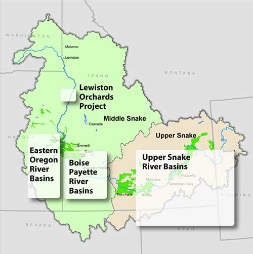
Hydromet — Reservoir and Streamflow Data
- Eastern Oregon River Basins (Owyhee, Malheur, Burnt, Powder)
- Boise and Payette River Basins
- Upper Snake River Basins
- Lewiston Orchards Project
For additional information about other basins and water temperature and precipitation select below:
- Boise River Basin, ID
- Lewiston Orchards, ID
- Malheur River Basin, OR
- Owyhee River Basin, OR-NV
- Payette River Basin, ID
- Powder River Basin, OR
- Snake River abv Idaho Falls, ID-WY
- Snake abv Milner, bel Idaho Falls, ID
AgriMet - Agricultural Weather Data
The runoff forecast percentages in the Water Supply Update represent operating forecasts prepared by Reclamation, and may differ in values and timeframes from those published by the National Weather Service and Natural Resources Conservation Service. For official forecasts please contact those agencies.
Regional Water Operations >>
Upper Snake Field Office Water Operations >>
River Flow Data from the USGS
Contacts
Boise, Payette and eastern Oregon basins:
- Call (208) 334-9134 for the daily streamflow recording.
- Email Melissa Jayo at mjayo@usbr.gov.
Upper Snake River Basin:
- Call (208) 670-0761
- Email Jeremy Dalling at jdalling@usbr.gov.
Click on the basin name to view reservoir storage diagrams including daily average streamflows.
 Owyhee Dam Boat Ramp at Owyhee Reservoir is permanently closed due to safety issues. Please use other ramps in the area such as the Gordon Gulch Ramp in Lake Owyhee State Park 2 miles south of the Owyhee Dam Boat Ramp, or the newly reconstructed Indian Creek Boat Ramp 4 miles south of the Owyhee Dam Boat Ramp.
