- Reclamation
- California-Great Basin
- Area Offices
- BDO
- Projects, Activities, Documents
- Yolo Bypass Salmonid Habitat Restoration and Fish Passage
Yolo Bypass Salmonid Habitat Restoration and Fish Passage
A prominent element of California’s flood control system and a critical migration corridor for fish.
- Fact Sheet (PDF - 935 KB)
The Central Valley used to be a vast system of wetlands, tidal marsh and floodplains, which allowed juvenile fish to move through the Sacramento River to the food-rich floodplains. As floodplain habitats diminished over time, fish were disconnected from their food source.
Reclamation and the California Department of Water Resources (DWR website) are partnering to reconnect floodplain habitat and improve fish passage for young salmon. The Yolo Bypass Salmonid Habitat Restoration
Project works to reconnect the floodplain for fish during the winter season and improve connectivity within the bypass and to the Sacramento River. The project provides seasonal inundation that mimics the natural process of the Yolo Bypass floodplain and improves connectivity within the bypass and to the Sacramento River.
The project primarily consists of a new Fremont Weir headworks structure, a new outlet channel, and downstream channel improvements. This enables juvenile salmon to feed in a food-rich area for a longer time, allowing them to grow rapidly in size and improving their chances of survival as they travel to the ocean. Improvements will also reduce stranding and migratory delays of adult salmon and sturgeon due to passage barriers.
The Project is included in Reclamation’s 2019 Proposed Action for the Long-term Operation of the Central Valley Project and the State Water Project, adopted in the 2019 National Marine Fisheries Service (NMFS) biological opinion, and included in the Reclamation’s 2020 Record of Decision. The NMFS biological opinion includes non-discretionary measures known as Reasonable and Prudent Measures (RPM). The terms and conditions of RPM1(g) states “Reclamation shall complete construction of the Fremont Weir component of the Yolo Bypass Salmonid Habitat Restoration and Fish Passage Project by 2022.
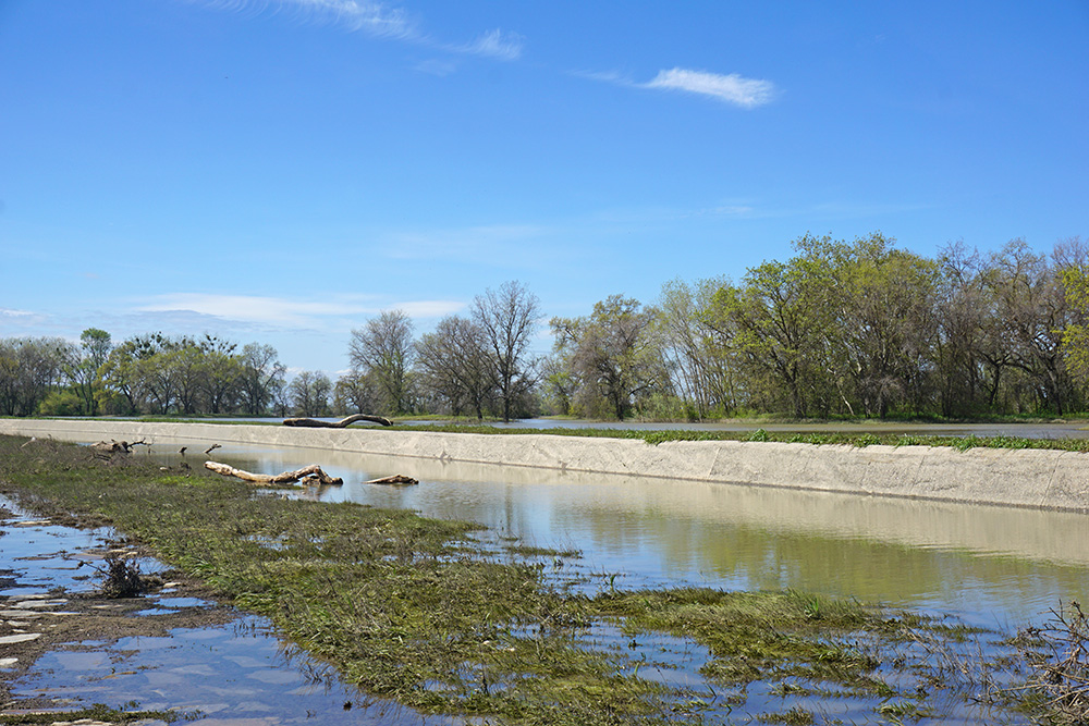
The Fremont Weir (pictured above), at the northern end, is a 1.8-mile-long concrete structure designed to allow flow into the Yolo Bypass during high-flow events when the Sacramento River is higher than the weir's 32-foot weir crest elevation. The weir has a concrete stilling basin just downstream of the crest and along its full length to minimize scouring during overtopping events. Once the Sacramento River recedes below the crest of Fremont Weir, fish are likely to become stranded in the stilling basin.
Environmental Impact Statement/Environmental Impact Report
- Record of Decision - September 19, 2019
The Record of Decision was originally signed on September 10th and was revised and re-signed on September 19th to reflect clarifying language on NEPA mitigation measures related to recreation. - Federal Register: Notice of Availability of the Final Yolo Bypass Salmonid Habitat Restoration and Fish Passage EIS/EIR– June 7, 2019
- Federal Register: Notice of Availability of the Draft Yolo Bypass Salmonid Habitat Restoration and Fish Passage EIS/EIR – December 28, 2017
- Presentation (PDF - 883 KB)
- Yolo Bypass Flow Modeling along the Fremont Weir – August 2020 (PDF - 8.8 MB)
- Yolo Bypass Salmonid Habitat Restoration and Fish Passage Project Draft Science Work Plan (PDF - 378 KB)
- Yolo Bypass Analytical Tool Independent Scientific Review – Sept. 7-8, 2018
- Response to Independent Review - May 23, 2018 (PDF - 882 KB)
- Draft Yolo Bypass Waterfowl Impact - Effects Analysis Tool
- Public Workshop – June 29, 2017
- Announcement (PDF - 24 KB)
- Presentation (PDF - 2.6 MB)
- Presentation (printer friendly) (PDF - 3.7 MB)
Working Group
The materials presented below are draft and preliminary and, as such, Reclamation and DWR make no warranties, representations or guarantees, either expressed or implied, as to the completeness, accuracy or correctness of the data nor accepts or assumes any liability arising from its use.
- Availability of Flow for Passage – Nov. 14, 2018 (PDF – 377 KB)
- Engineering and Permitting Next Steps – Nov. 14, 2018 (PDF – 148 KB)
- Evaluation Factors – Oct. 23, 2017 (PDF - 1.3 MB)
- Update – Aug. 16, 2018 (PDF – 455 KB)
- Change in Wetted Acres TUFLOW Results – April 5, 2017 (PDF - 2.3 MB)
- Biological Assessment Plan – April 5, 2017 (PDF - 340 KB)
- Air Quality Report Presentation – April 5, 2017 (PDF - 360 KB
- Alternatives Overview – March 23, 2017 (PDF - 775 KB)
- Summary of Alternatives – March 23, 2017 (PDF - 70 KB)
- Project Updates – March 23, 2017 (PDF - 193 KB)
- Alternatives Update – Oct. 20, 2016 (PDF - 4.2 MB)
- Alternative Analysis – May 17, 2016 (PDF - 385 KB)
- Status of Fish Behavior Modeling – May 17, 2016 (PDF - 1.3 MB)
- Alternative 4 Components – May 17, 2016 (PDF - 557 KB)
- Alternative 4 (Sizing and Configuration) – May 17, 2016 (PDF - 263 KB)
Scoping Materials - 2013
- Yolo Bypass Scoping Report (PDF - 140 KB)
- Yolo Bypass Scoping Meeting Comment Card (PDF - 1.6 MB)
- Yolo Bypass Scoping Meeting Slides (PDF - 900 KB)
- West Sacramento Yolo Bypass Meeting Map (PDF - 1 MB)
- Woodland Yolo Bypass Meeting Map (PDF - 835 KB)
- Notice of Intent (PDF - 1.1 MB)
- Notice of Preparation (PDF - 1.3 MB)
Implementation Plan - 2012
- NMFS Concurrence Letter on Yolo Bypass Implementation Plan (PDF - 750 KB)
- Yolo Bypass Implementation Plan Transmittal Letter (PDF - 733 KB)
- Yolo Bypass Salmonid Habitat Restoration and Fish Passage Implementation Plan (PDF - 2.6 MB)
Note: documents in Portable Document Format (PDF) require Adobe Acrobat Reader 5.0 or higher to view download Adobe Acrobat Reader.
