

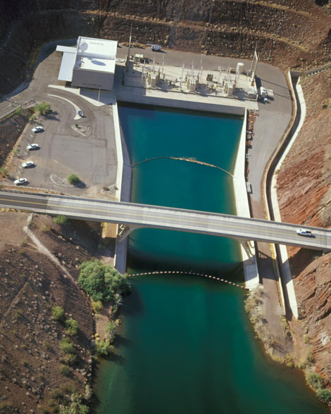
 Aerial view of the Mark Wilmer pumping plant located near Lake Havasu, Arizona. It is one of fourteen pumping plants located along the 336-mile long delivery system, lifting water 3,000 feet. An additional pump/generating plant is located off the main aqueduct at New Waddell Dam. (Reclamation photo)
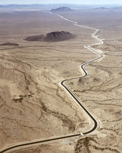 Iconic image of the Central Arizona Project canal, reaching 336 miles from the Colorado River to the Tohono O'odham nation south of Tucson, Arizona.
On May 6, 1973, a groundbreaking ceremony on the banks of Lake Havasu heralded the beginning of the largest water delivery project in Arizona's history. Construction of the project began with the award of a contract for the Havasu Intake Channel Dike and excavation for the Havasu Pumping Plant (now Mark Wilmer Pumping Plant) on the shores of Lake Havasu.
Through mountains, under highways, into the middle of Arizona, the Central Arizona Project aqueduct, when completed, would raise Colorado River water approximately 3,000 feet above sea level and deliver it 336 miles, via canals, siphons, tunnels, and pumping plants, through desert and farmlands and Indian reservations to the major metropolitan areas of the state: Maricopa, Pinal, and Pima counties.
In addition to the metropolitan water supply, the project would provide power, flood control, outdoor recreation, agricultural irrigation, water for Indian water rights settlements, and fish and wildlife habitat benefits. Authorized in September 1968, the project was projected to deliver an average 1.5 million acre-feet of Arizona's 2.8 million acre-foot Colorado River entitlement each year.
Havasu Intake Channel Dike and Hayden-Rhodes Aqueduct
This dike created an intake channel on Lake Havasu on the south side of the Bill Williams River arm of the lake. Through the channel Colorado River water is delivered to the high-lift Mark Wilmer Pumping Plant. A key purpose of the dike is to help prevent sediment from entering the intake channel. The Mark Wilmer Pumping Plant lifts the water approximately 824 feet from the lake to the inlet portal of the Buckskin Mountains Tunnel.
The water flows through the approximately 7-mile-long tunnel and is discharged into the Hayden-Rhodes Aqueduct, which will eventually convey it to the Phoenix metropolitan area. The Hayden-Rhodes Aqueduct consists of about 173.9 miles of open, concrete-lined canal, seven major inverted siphons with a total length of about 7.4 miles, three tunnels totaling 8.2 miles, and 0.6 mile through three pumping plants. The aqueduct has a maximum capacity of 3,000 cubic feet per second (cfs). Relift pumping stations are located at Bouse Hills, Little Harquahala Mountains, and near the Hassayampa River. The total pump lift from the Colorado River to the Phoenix service area is about 1,200 feet.
Hayden Rhodes Aqueduct:
| Location | From the Havasu diversion facilities at Lake Havasu on the Colorado River to the Salt River in the Phoenix metropolitan area. |
| Construction period | 1973-1985 |
| Total length: | 190 mi |
| Open channel | 173.9 mi |
| Closed channel | 16.1 mi |
| Capacity | 3,000 cfs |
| Typical section, concrete-lined | With exception of Reach 1, or first 17 miles of aqueduct |
| Bottom width | 24 ft |
| Side slopes | 1.5:1 |
| Water depth | 16.5 ft |
| Concrete lining thickness | 3.5 in |
Reach 1 - Hayden-Rhodes Aqueduct
| Location | First 17 miles of the Hayden-Rhodes Aqueduct. |
| Construction period | 1973-1985 |
| Typical section, concrete-lined | |
| Bottom width | 80 ft |
| Side slopes | 1.5:1 |
| Water depth | 10-25 ft |
| Concrete lining thickness | 3.5 in |
Indian Distribution System Division
In 1976, project water was allocated for irrigation use by Indian Tribes in Arizona. In 1980, the Secretary of the Interior announced a modified allocation to 309,828 acre-feet, and raised the Tribes' priority for receiving water. The allocation of project water to non-Indian irrigation users, municipal and industrial water users, and Indian users was approved on February 10, 1983. Many Indian water rights settlements would follow in subsequent decades.
Power Sources
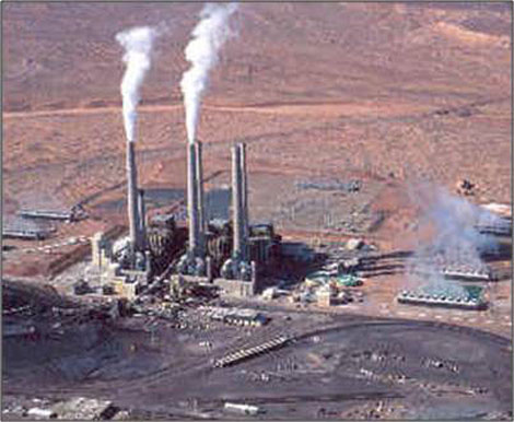 Navajo Generating Station, located near Page, Arizona, supplies power to the CAP pumping plants which lifting water 3,000 feet along over 300 miles.
The Colorado River Basin Project Act allowed the federal government to participate in the non-federal Navajo Generating Station (NGS), near Page, Arizona, to provide power for pumping water along the CAP aqueduct. NGS provides electricity to customers in Arizona, Nevada and California. Reclamation's share of NGS annual output is 24.3 percent, or 546,750 kilowatts per year for the CAP.
The Navajo Generating Station was constructed by the Salt River Project Agricultural Improvement and Power District of Arizona, now part of the Salt River Project (SRP). In addition to Reclamation and the SRP, other participants in the Navajo Project are NVEnergy (formerly Nevada Power Co.), Tucson Electric Power Co., and Los Angeles Department of Water and Power.
Construction of the Navajo Generating Station began in April 1970. The third, and last, generating unit was completed and placed in operation on April 30, 1976. Until energy was required for the CAP or other purposes authorized by Public Law 90-537, Reclamation's share of the interim energy produced was sold to other participants in the station and to the Southern California Edison Co.
Sources:
http://www.usbr.gov/lc/phoenix/projects/capproj.html
http://www.usbr.gov/projects/Project.jsp?proj_Name=Central+Arizona+Project
For more information:
http://www.cap-az.com/
Following is a photo essay illustrating the beginning construction activities of the various components of the Central Arizona Project.
Photos of CAP Construction
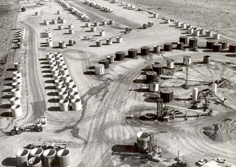 During construction of the Central Arizona Project, some areas required that the water be delivered via huge concrete pipe sections, known as siphons, that could travel beneath obstructions such as roads or riverbeds. The concrete pipe sections were cast and stored as close to their eventual placement as possible.
 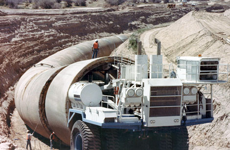 Pipe sections were then delivered to the excavated channel using this special delivery method, dubbed "The Pipemobile."
 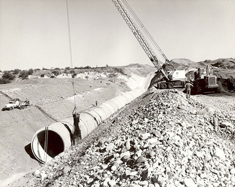 Pipe sections for the Agua Fria siphon being placed.
 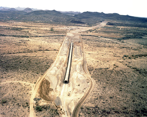 A section of the Agua Fria siphon.
 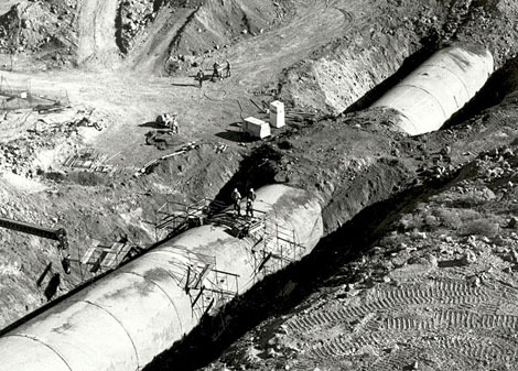 A section of the Agua Fria siphon being buried. Note the workmen standing on top of the pipe to get an idea of the pipe size.
 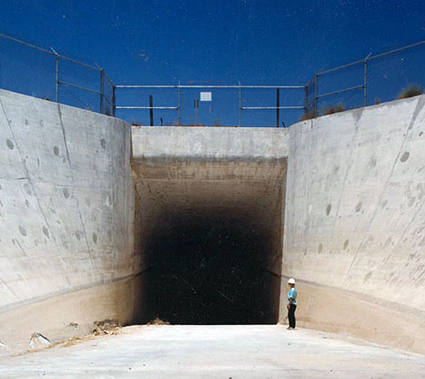 Agua Fria siphon outlet; water returns to the canal.
 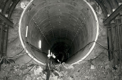 Other areas of the Central Arizona Project required tunneling through mountains or hills.
 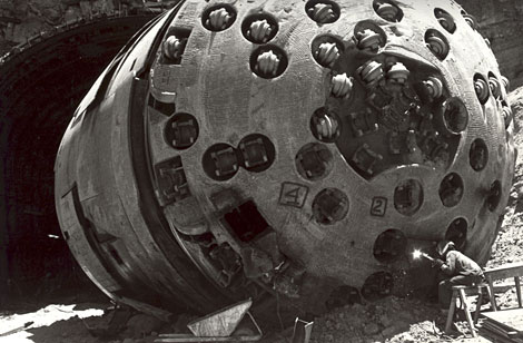 This unusual piece of equipment, known appropriately as a "mole", was used to tunnel through mountains.
 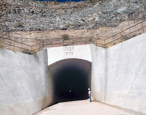 Entrance to the Agua Fria tunnel, 1970.
 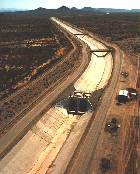 Construction of the Central Arizona Project canal, showing a turn-out structure.
 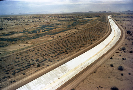 Completed section of the CAP canal, prior to being filled with Colorado River water.
 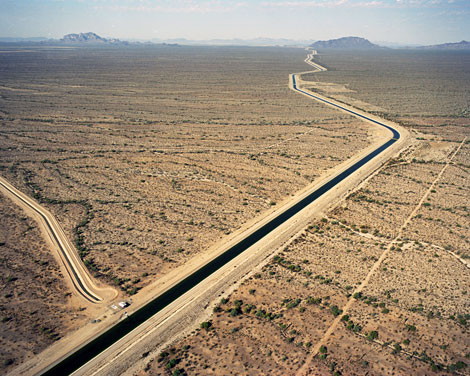 Central Arizona Project Canal
 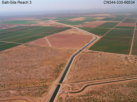 Central Arizona Project canal, showing farmlands made possible by the delivery of irrigation water and a turn-out structure into a local canal.