Lower Colorado River Mainstream Evaporation and Riparian Evapotranspiration Losses Report
Quick Links:
- Lower Colorado River Mainstream Evaporation and Riparian Evapotranspiration Losses Report
- Appendix 1 – Reaches Identified in the Lower Colorado River Mainstream Evaporation and Riparian Evapotranspiration Losses Report
- Appendix 2 – LCRAS Open Water Monthly Evaporative Losses
- Appendix 3 – Lake Mead, Lake Mohave, and Lake Havasu Evaporation from Reclamation’s Hydrologic Database (HDB)
- Appendix 4 – LCRAS Riparian Monthly Evapotranspiration Losses by Vegetation
- Appendix 5 – Evaporation and Riparian Evapotranspiration (ET) Coefficients
- Appendix 6 – Evaporation and Riparian Evapotranspiration (ET) Rates
On August 16, 2022, the Bureau of Reclamation (Reclamation) and Department of the Interior announced several administrative actions for consideration to improve and protect the long-term sustainability of the Colorado River System. The System is currently experiencing prolonged drought and low runoff conditions accelerated by climate change that have led to historically low water levels in Lakes Powell and Mead (Reclamation, 2021). One of the actions included reviewing and prioritizing additional administrative initiatives to address system losses in the lower Colorado River mainstream. As part of that action, this report provides an overview of historical mainstream evaporation and riparian evapotranspiration (ET) losses along the lower Colorado River and presents methodologies used to develop those datasets. This report does not make recommendations on how to account for system losses in the lower Colorado River mainstream.
Estimates of lower Colorado River mainstream evaporation and riparian ET losses provided in the report were divided into five reaches, as follows:
- Reach 1: Lake Mead
- Reach 2: Hoover Dam to Davis Dam
- Reach 3: Davis Dam to Parker Dam
- Reach 4: Parker Dam to Imperial Dam
- Reach 5: Imperial Dam to the Northerly International Boundary (NIB) with Mexico
This report presents two datasets: (1) Lower Colorado River Annual Summary (LCRAS) of ET and Evaporation; and (2) Reclamation’s hydrologic database (HDB). The LCRAS dataset uses aerial imagery to determine open water and riparian acreages, then applies area and cover type ET coefficients to calculate evaporation and riparian ET estimates along the mainstream lower Colorado River and reservoirs between Hoover Dam and Mexico. HDB contains a computational processor that estimates evaporation losses from the lower Colorado River mainstream reservoirs (Lake Mead, Lake Mohave and Lake Havasu) based on lake elevations, the related surface water area, and monthly evaporation coefficients specific to each reservoir. HDB stores these estimates in its database. It does not provide evaporation estimates from the river sections between reservoirs and does not provide estimates of riparian ET.
From 2017 to 2021, the average annual evaporation loss for the lower Colorado River basin is estimated to be about 860 thousand acre-feet (kAF). This estimate uses HDB evaporation data for Lake Mead (reach 1), since LCRAS data is not available for that area, then uses LCRAS data for the remaining areas, to maintain as much consistency in the data sources as possible.
Riparian ET estimates are not available for Lake Mead but are available for reaches 2 through 5. From 2017 to 2021, the average annual riparian ET loss occurring between Hoover Dam and the Northerly International Boundary is estimated to be about 445 kAF.
In summary, from 2017 to 2021, the average annual total system loss (evaporation and riparian ET) for Lake Mead to the Northerly International Boundary is estimated to be about 1,304 kAF. The following table and graph shows the breakdown of the amount and types of evaporation occurring within each reach defined in the report.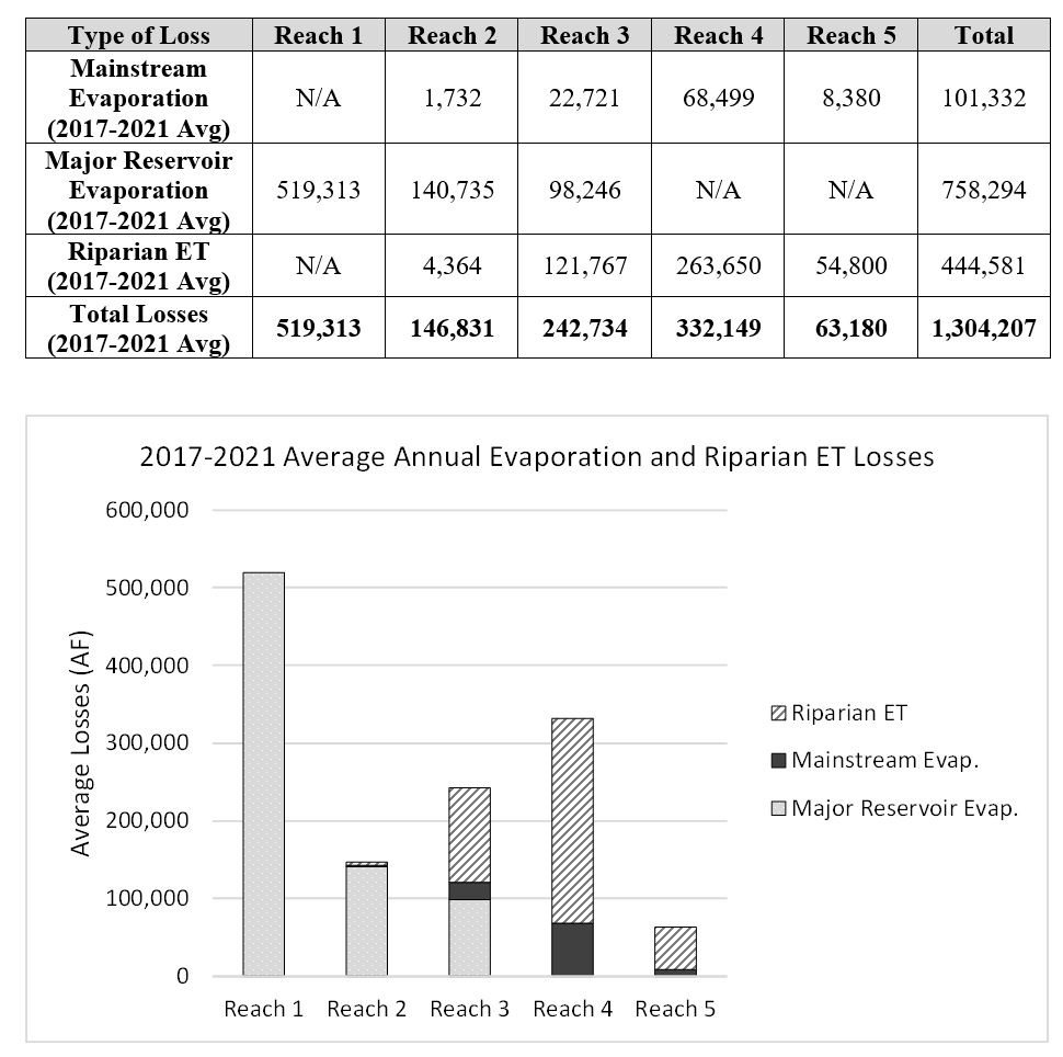
The Appendices provide further detail about the information collated within the report. Appendix 1 contains figures showing detailed maps of the individual reaches that were defined. Appendix 2 provides monthly breakdowns of the annual LCRAS evaporation values shown in the report. Appendix 3 provides similar evaporation data breakdowns for the reservoirs estimated using HDB. Appendix 4 provides a detailed breakdown of the riparian ET, both by reach and by vegetation types. Appendix 5 contains further details regarding the coefficients that are utilized by LCRAS and HDB in their respective methods. Appendix 6 provides details on the evaporation and riparian ET rates used in LCRAS.
For additional information or questions, contact:
e-mail: kdickson@usbr.gov
phone: 702-293-8574
