Lower Santa Cruz River Basin Study
 Surface Water Modeling GIS Application
Supply and Demand Assessment by Central Arizona Project
Revised Groundwater Modeling Technical Memorandum
Climate Change and Surface Water Hydrology (Hydroclimate Analysis) Technical Memorandum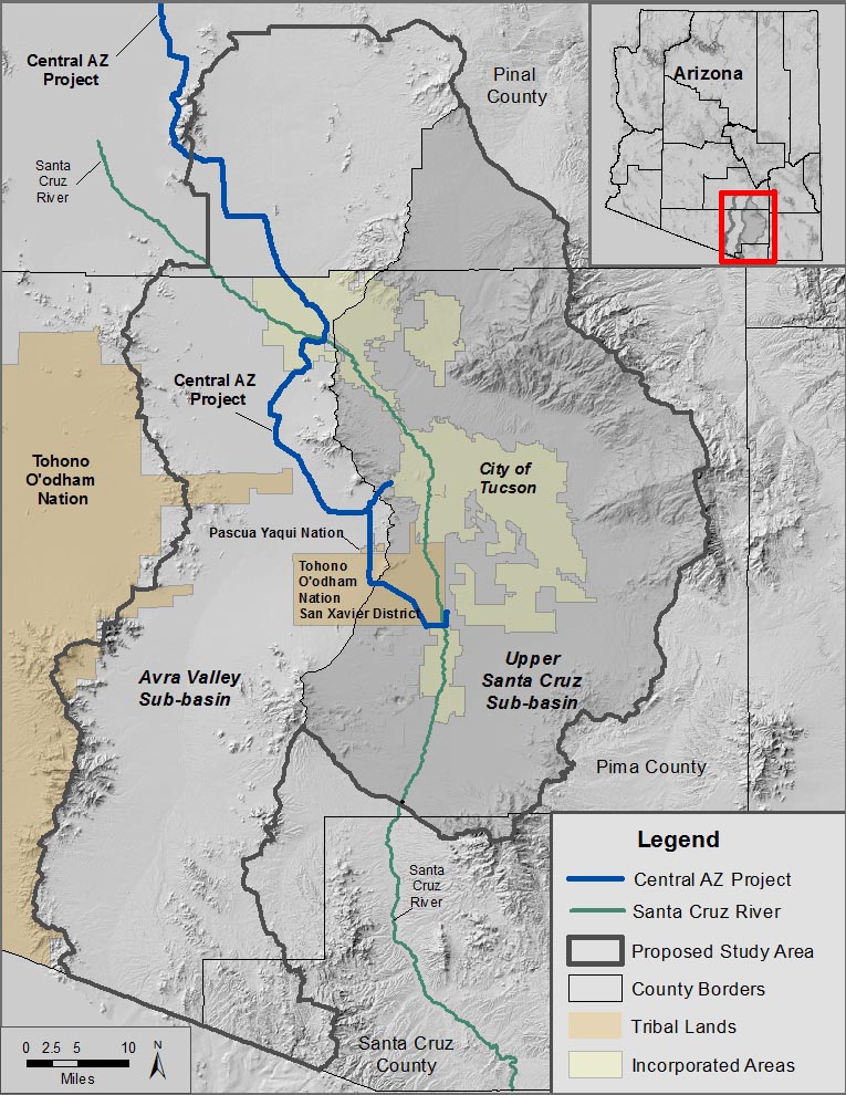
Background: For over 60 years, residents of the Lower Santa Cruz River (LSCR) Basin in Southern Arizona relied on groundwater to meet most water supply needs, with pumping greatly exceeding replenishment. In 1993, the Central Arizona Project (CAP) began delivering Colorado River water to the LSCR Basin. However, there are still significant supply-demand imbalances due to a lack of water delivery infrastructure, insufficient recharge and recovery capacity, and the cost of constructing new facilities.
Uncertainty about the future compounds these issues. The CAP has junior priority rights on the Colorado River; thus CAP sub-contractors will bear the brunt of imminent shortages. Climate change poses additional threats and may aggravate the impacts of future droughts. The 5-year study’s overarching goal is to identify where physical water resources are needed in order to mitigate supply-demand imbalances and to develop a strategy to improve water reliability for the municipal, industrial, agricultural, cultural and environmental sectors.
The LSCR Basin Study will be a technical assessment and will not make statements of policy or future commitments by Reclamation or its cost-share partners.
Cost-Share Partners: Southern Arizona Water Users Association, Pima Association of Governments (PAG), Cortaro-Marana Irrigation District, Arizona Department of Water Resources (ADWR), Central Arizona Water Conservation District, and the University of Arizona.
Study Area: The LSCR Basin Study Area encompasses the groundwater basin designated by ADWR as the “Tucson Active Management Area” (TAMA). Most water use takes place between the Pima County / Santa Cruz County line south of the Tucson metropolitan area, and the Pima County / Pinal County line to the north.
Study Objectives include:
- Development of future demand projections under a variety of growth scenarios
- Selection of relevant climate change scenarios, including Colorado River shortages.
- Update of the ADWR TAMA Groundwater Model to evaluate effects of scenarios on groundwater levels, including shallow groundwater (riparian) areas
- Development of system reliability metrics to identify infrastructure vulnerabilities
- Formulation of adaptation and mitigation strategies to address water supply vulnerabilities and preserve groundwater dependent (riparian) ecosystems.
- Assessments of adaptation and mitigation strategies and trade-off analysis
Public Involvement: The PAG will be the lead agency for stakeholder involvement. A Stakeholder Advisory Team will be coordinated through PAG’s Watershed Planning Subcommittee or Environmental Planning Advisory Committee. There will also be public meetings, news releases, informational mailings, a study website and an email address for submission of comments.
Cost: The total cost of the year study is $2,065,750. Cost-share partners will contribute $1,033,000 of in-kind services (e.g. staff time, facilities). Reclamation’s contribution of $1,032,750 may only be used to support work performed by Reclamation or its contractors.
Reclamation's Basin Study Program >>Lower Santa Cruz River Basin Study - Fact Sheet >>
Lower Santa Cruz River Basin Study - Memorandum of Agreement (MOA) >>
Lower Santa Cruz River Basin Study - Amendment 1 to Memorandum of Agreement >>
Lower Santa Cruz River Basin Study - Amendment 2 to Memorandum of Agreement >>
Lower Santa Cruz River Basin Study - Attachment A - Amended Plan of Study >>
Comments on the Basin Study may be submitted to: bor-pxa-lscrbs@usbr.gov
| Contact Information - Co-Study Managers: | |
|
Eve Halper Planner (Water Resources) (623) 773-6279 ehalper@usbr.gov Bureau of Reclamation |
Wally Wilson Water Resources Manager, Metro Water 520-209-2818 wwilson@metrowater.com |
