

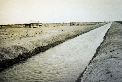
 Desert homestead along the Eastern Canal three miles east of Mesa, 1910. (Reclamation photograph)
The largely arid American West receives a distinctly small share of the Earth's fresh water, and not surprisingly, water dictates where people live. Like pioneering settlers throughout the West, settlers in Arizona Territory understood that there was water, but it was not always available when or where they needed it. They developed small-scale storage and irrigation projects, and soon created a complex water law to assign available water rights based on the concept of prior appropriation ("first in time, first in right"). Early water development projects were fairly simple: settlers diverted water from a stream or river to fields. In many areas, demand far outstripped supply, and settlers wanted to store runoff to insure that water would be available during dry periods.
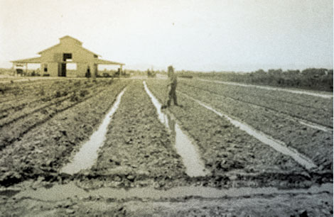 Furrow irrigation on Mr. A.B. Fowler's Ranch, 1911. (Reclamation photograph).
In the late 1800s, irrigation projects were intended to make arid but fertile lands productive; the arid lands could be "reclaimed." John Wesley Powell provided one spark for reclamation projects through publication of his extensive explorations of the American West. Private pressures through publications, irrigation organizations, and "congresses"; non-partisan Western political pressures; and detailed studies conducted by Government surveyors contributed to discussions that helped influence public opinion, Congress, and the executive branch to rally under a "reclamation" banner. Congress passed the Desert Land Act (1877) to encourage development of Western irrigation projects. In 1888, Congress appropriated funds to study irrigation potential on the arid western lands. Then, in 1890 and 1891, Congress passed legislation reserving rights-of-way for reservoirs, canals, and ditches in the public domain.
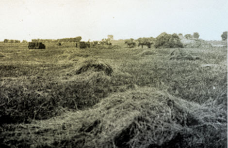 Irrigation turned former desert into productive agricultural land as this hay field near Chandler illustrates, 1906. (Reclamation photograph)
In the 1890s, many citizens in Arizona Territory, like their counterparts in other parts of the arid West, began favoring reclamation projects. A lingering Western drought was one catalyst for a series of National Irrigation Congresses that drew much attention to the need for a greater Government role in the reclamation of arid lands in the West. The 1894 Carey Act asserted responsibility to the States and Territories to oversee irrigation development. It granted each Western State or Territory up to 1 million acres of public domain lands on the condition that the lands be irrigated and occupied. Settlers were given one decade to cultivate at least 20 acres out of each 160-acre tract. Once settlers submitted proof of irrigation and settlement to the Department of the Interior, the lands would be turned over to the States and, in turn, patented to the settlers. But because State and Territorial governments lacked the financial resources or technical expertises to design, construct, operate, and maintain large-scale irrigation projects, the Carey Act was largely unsuccessful.
Prominent Arizona Territorial leaders like Benjamin Fowler, Dr. Alexander J. Chandler, and James McClintock, among others, had long argued for more Government involvement in reclamation projects. The presidential election of 1900 saw pro-irrigation, pro-reclamation planks in both Democratic and Republican platforms. On June 17, 1902 those calling for a greater Government role in developing irrigation projects saw their dream come true when President Theodore Roosevelt signed a National Reclamation Act into law.
(Modified and adapted from: National Register of Historic Places Multiple Property Documentation Form, Salt River Project, Arizona, prepared by Jim Bailey, Bureau of Reclamation, June 2010.)