- Reclamation
- Missouri Basin and Arkansas-Rio Grande-Texas Gulf
- AgriMet
- Toston, Montana
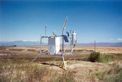
AgriMet Data Collection Station, near Toston, Montana, part of the Missouri Basin Agricultural Data Collection System.
AgriMet: Weather & Crop Water Use Charts
The AgriMet station TOSM was installed May 19,1992. The station was relocated to its present location on March 26, 2001. The cooperating agencies involved with this station are the Bureau of Reclamation, Northwest Energy Efficiency Alliance, the Toston Irrigation District, and Broadwater Conservation District.
The site is now approximately 4.5 miles southwest of Toston, Montana. Latitude: 46 07 20 longitude: 111 29 41 elevation-4058'
The old location was approximately 2 miles west of Toston, Montana. Latitude: 46 09 58 longitude: 111 28 33 elevation-3920'
AgriMet provides generic local crop and weather information accessed via the links on the individual station page.
AgriMet is excited to announce a partnership with Washington State University to incorporate AgriMet data into WSU's AgWeatherNet Irrigation Scheduler program. To customize crop consumptive water use specific to your field or fields, use the mobile link or desktop link. Note, to use either link, you have to have a AgWeatherNet account (free registeration) which can be done through either of these two links.
NOTE: the AgriMet pages have recently been updated. Please click here to navigate to the updated webpages
Dayfiles Information:
Enter date and parameter codes then submit your request.
AgriMet is excited to announce a partnership with Washington State University to incorporate AgriMet data into WSU's AgWeatherNet Irrigation Scheduler program. To customize crop consumptive water use specific to your field or fields, use the mobile link or desktop link. Note, to use either link, you have to have a AgWeatherNet account (free registeration) which can be done through either of these two links.
NOTE: the AgriMet pages have recently been updated. Please click here to navigate to the updated webpages
For further information about AgriMet, contact: mbwebmaster.
