The Missouri Basin Cooperative
Agricultural Weather Network
About AgriMet
The Bureau of Reclamation, in cooperation with other federal, state, and local sponsors, has developed an agricultural weather information system called "AgriMet," with the purpose of promoting water and energy conservation. AgriMet is a contraction of the words AGRIculture, and METeorology. The original AgriMet program started in the Pacific Northwest in the 1980s, and was expanded into Montana, east of the continental divide, in the 1990s. AgriMet is currently a network of more than 90 automated weather stations that collect and telemeter site-specific weather data.
This information is translated into crop-specific water use information. The primary emphasis is on irrigation management – applying the right amount of water at the optimal time.
While AgriMet's primary purpose is modeling evapotranspiration, or the amount of water used by a crop, there are many other uses of AgriMet data, including integrated pest management, frost protection, and other crop management activities.
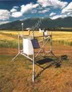
A photo of a typical AgriMet station, which uses solar powered batteries to collect and transmit weather data.
How Does an AgriMet Station Work?
<back to top> <next topic>
The photo to the right displays a typical AgriMet station, which consists of a data collection platform, transmitter, antenna, battery, solar panel and various sensors. The data collection platform samples sensors on a preset schedule, stores, and then transmits the data through a geostationary satellite.
Each AgriMet station is equipped to monitor:
- Air Temperature
- Solar Radiation
- Relative Humidity
- Wind Speed and Direction
- Precipitation
Additional sensors, installed at some of the AgriMet stations also monitor:
- Soil Temperature and/or Moisture at Various Depths
- Crop Canopy Temperature and/or Humidity
- Diffuse Solar Radiation
- Pan Evaporation
- Peak Wind Gust
While all stations transmit on a preprogrammed schedule (every four hours), they can also be programmed to transmit on the occurrence of a given event (i.e. rainfall). Transmissions can be triggered when a monitored parameter falls above or below threshold values, or exceeds a specified rate of change. This can be important, for example, when producers must watch temperatures closely to begin protection measures against frost.
AgriMet stations require little maintenance. Stations are self-contained units requiring no external power source: they are powered by storage batteries, and are recharged by solar energy. Each AgriMet station is subjected to a rigorous calibration and maintenance visit each year. All sensors are carefully inspected and calibrated in preparation for the growing season.
The 25 active weather stations in Montana are located at sites that closely represent irrigated crop environments throughout the state. The Pacific Northwest Region's AgriMet network also has more than 65 additional stations, located in Idaho, Wyoming, Washington, Oregon, California, and Nevada.
What is Evapotranspiration, and Why all of the Interest?
<back to top> <next topic>
Agriculture accounts for 80 to 90 percent of all water use in the western states. A plant can be thought of as a sponge, in some respects. Plants move water up from the soil, into the root zone, and then release this moisture through the leaves, into the atmosphere. Some of the water is retained for plant growth, but the majority is transpired. Of course, the amount of water used during later stages of growth is great than when a plant just emerges from the soil.
Evapotranspiration, known most commonly simply as "ET", is the amount of water lost to the atmosphere by direct evaporation of water from soil and plant surfaces, plus the transpiration from within the plant. Accurate modeling of ET can result in optimum water applications. This can save energy and costs related to pumping, as well as helping to maximize the efficient use of limited irrigation water.
AgriMet uses the Kimberly-Penman ET modeling procedure, developed by the Agricultural Research Service in Kimberly, Idaho in 1982. Since there are so many types of crops, alfalfa is used as a benchmark to calculate a standard reference ET. Individual crop ETs can then be calculated by multiplying the reference ET by a crop coefficient. Crop coefficients vary throughout the season, based on the current stage of plant development. Daily crop water use information is computed based on these variable crop coefficients.
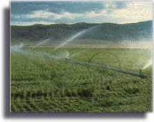
Irrigators use this information to schedule irrigation water application. Knowing the water holding capacity of their soil, an irrigator tracks the modeled crop water use. When it reaches the maximum allowed depletion level, it is time to irrigate again.
Irrigation scheduling using AgriMet ET data can provide significant savings in water, pumping costs, fertilizer, herbicide, and pesticide applications.
Further, everybody benefits from reduced soil erosion, and the protection of surface and ground water quality.
How is AgriMet Supported?
<back to top> <next topic>
Reclamation coordinates an extensive partnership of state, federal, and private interests that financially support the ongoing operation and maintenance of the AgriMet System. These costs are surprisingly low, due to the use of an existing infrastructure for data collection, analysis, and dissemination.
Contingent on the availability of funds, Reclamation will cost-share with potential sponsors for the initial purchase and installation of a new AgriMet station. Sponsors then support the ongoing operation and maintenance costs through an agreement with Reclamation.
Primary sponsorship of the AgriMet network and information system is provided through the U.S. Bureau of Reclamation and the Bonneville Power Administration (BPA). Other cooperators include the Natural Resources Conservation Service and other agencies of the U.S. Department of Agriculture, the National Weather Service, electric utilities, irrigation districts, land grant universities, and other State and local agricultural organizations and water resource agencies. (See links to Partners, Irrigation, Other ET & Weather, Agricultural, and Water Resources Information)
How Do I Access AgriMet?
<back to top> <next topic>
For information on the AgriMet program in Montana, east of the continental divide, see the Missouri Basin's AgriMet Station List where you can access daily weather data, crop water use charts, and other related information. The individual station pages provide access to general AgriMet information, weather data, regional forecasts, and daily and seasonal crop water use information for AgriMet stations located throughout Montana. There is also a variety of other irrigation, crop and soils information files that may be accessed through the Irrigation Guide option.
Reclamation's Regional Office in Boise, Idaho maintains the AgriMet satellite receiving site, and transfers the collected data for the stations in eastern Montana to Reclamation's Missouri Basin Regional headquarters, in Billings, Mont. Transmissions from AgriMet are processed and stored in an ALPHA/DMS minicomputer as a subset of Reclamation's regional Hydromet System.
For information on the AgriMet program in Montana, west of the continental divide, and the rest of the Pacific Northwest, see the PN Region's AgriMet homepage.
For users requiring more detailed weather information, there is a menu-driven system that can be accessed through a modem and personal computer. This method requires a User's Agreement. Interested parties should contact the AgriMet Program Coordinator (shown below) for additional information.
Network Information and Station Equipment
<back to top>
In 1983, in cooperation with the Bonneville Power Administration (BPA), the U.S. Bureau of Reclamation (Reclamation) began "piggy-backing" a network of automatic agricultural weather stations onto Reclamation's regional HYDROMET satellite telemetry network. As a subset of the overall HYDROMET network, this agricultural network, dedicated to crop water use modeling and other agricultural applications, has been identified as AgriMet.
Typical Telecommunications Equipment (Manufacturer):
- Data Collection Platform, Model 8004 (Sutron Corporation)
- YAGI antenna & cable, Model 8200 A
- 100 amp-hr battery & cable, #8200 PSB
- Solar panel & cable, Model SX-10
- Integrator, solar
- 190 amp-hr battery (Exide Corporation)
- Integrator, (USDA-ARS (Burgess))
- Integrator, wind run (USDA-ARS (Burgess))
Typical Sensors:
- Thermistor, YSI #44212 (Yellow Springs Instruments)
- Wind Monitor #05103 (R.M. Young)
- Pyranometer, Model LI-200SB (Li-Cor)
- Relative Humidity Probe, Model 2013A (Texas Electronics)
- Relative Humidity Probe, Model HMP-35A (Vaisala)
- Tipping Bucket Rain Gage, 6010 & 6011-A (Qualimetrics)
- Precipitation Collector, 12 inch (Belfort)
<back to top> <MB AgriMet Station List>
For further information about AgriMet, contact: mbwebmaster.
