- Reclamation
- Missouri Basin and Arkansas-Rio Grande-Texas Gulf
- AgriMet
- Jefferson River Valley, near Whitehall, Montana
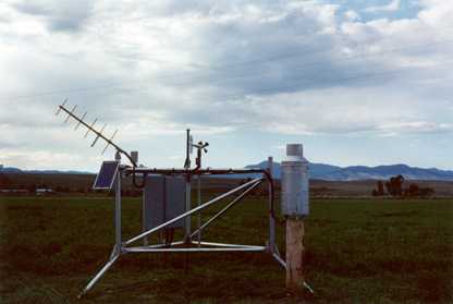
AgriMet Data Collection Station, near Whitehall, MT, part of the Missouri Basin Agricultural Data Collection System.
AgriMet: Weather & Crop Water Use Charts
The AgriMet Station JVWM was installed May 18, 2001. The cooperating agencies involved with this station are the Bureau of Reclamation, Jefferson River Watershed Council, Jefferson Valley Conservation District, and the National Center for Appropriate Technology (NCAT).
The site is approximately 6.5 miles southwest of Whitehall, Montana. Latitude: 45 47 52 Longitude 112 09 55 elevation-4415'
AgriMet provides generic local crop and weather information accessed via the links on the individual station page.
AgriMet is excited to announce a partnership with Washington State University to incorporate AgriMet data into WSU's AgWeatherNet Irrigation Scheduler program. To customize crop consumptive water use specific to your field or fields, use the mobile link or desktop link. Note, to use either link, you have to have a AgWeatherNet account (free registration) which can be done through either of these two links.
Dayfiles Information:
Enter date and parameter codes then submit your request.
AgriMet is excited to announce a partnership with Washington State University to incorporate AgriMet data into WSU's AgWeatherNet Irrigation Scheduler program. To customize crop consumptive water use specific to your field or fields, use the mobile link or desktop link. Note, to use either link, you have to have a AgWeatherNet account (free registration) which can be done through either of these two links.
For further information about AgriMet, contact: mbwebmaster.
