- Reclamation
- Missouri Basin and Arkansas-Rio Grande-Texas Gulf
- Multimedia
- The Inception of the Pick-Sloan Missouri Basin Program
| The Inception of the Pick-Sloan Missouri Basin Program | |
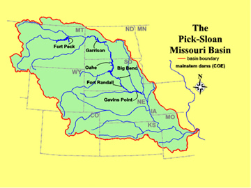 The Missouri Basin extends to Montana, Wyoming, Colorado, Kansas, Nebraska, North Dakota, South Dakota, Minnesota, Iowa, Missouri, and the Canadian provinces of Saskatchewan and Alberta. |
The Missouri River drains an area of about one-sixth of the lower 48 states. Currently the river is a resource providing domestic and irrigation water, electric power, recreation, and conservation benefits to millions of people. It wasn't always that way. Subject to annual droughts in summer and fall and with rainfall in two-thirds of the basin averaging under 20 inches per year (vs. 40 inches in Indiana, for example),before the building of hydraulic facilities the area was known as the Great American Desert. The Bureau of Reclamation was established to reclaim otherwise unproductive lands for settlement and agricultural use, and began its first irrigation projects in the Missouri basin. The early irrigation projects, such as Belle Fourche in South Dakota and Kendrick in Wyoming, were local, not envisioning basin-wide drought relief and flood control benefits. |
 Sand drifted 6 feet deep near barns in South Dakota in 1935 |
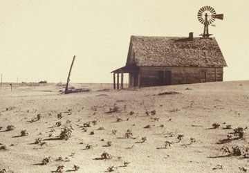
In the dust bowl days of the early 1930's thousands of farmers were forced from their homes by drought as their crops withered and their topsoil blew away. It was not surprising that Congress would turn to the Bureau of Reclamation – the irrigation bureau – in 1939 to come up with ideas to provide relief to the drought-plagued lands of the dust bowl. The population of the Missouri Basin had declined significantly during the dust bowl days, and the decline persisted during World War II as people left the area to assist in the war effort. |
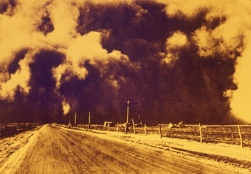 Oncoming dust storm in the 1930's
|
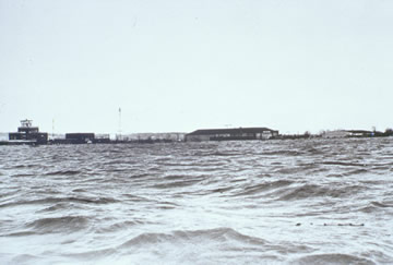
The other water problem in the Missouri basin was the opposite: floods. The basin was normally subject to yearly flooding from snowmelt or sudden heavy rainfall, and even in the 1930's drought period the Missouri and its tributaries often went on the rampage. By the 1940's flood damage along the Missouri Basin's major streams and tributaries were averaging $77 million per year--equal to about $900 million per year in 1999 dollars. As early as 1922, presidential commissions had published reports urging that projects for managing the nation's water resources be designed to serve many uses, not for single purposes. But it took the twin crises of drought damage and flood losses to provide the impetus for a major basin-wide coordinated plan. In 1824 the Corps of Army Engineers had been given jurisdiction to maintain navigable rivers for interstate commerce. Other responsibilities related to navigation were added subsequently. For example, the General Dam Acts of 1906 and 1910 gave the Corps review authority over non-federal power development on navigable rivers before final approval by Congress. In 1943, motivated by flood damage, the House Committee on Flood Control passed a resolution asking the Corps of Engineers to produce a plan for flood control and other purposes in the Missouri Basin. |
|
|
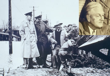 William Sloan and Col. Lewis Pick |
The result was the Missouri River Basin Project, authorized by the Flood Control Act of 1944, at a time when there was a significant effort to encourage people to return to the great plains. The project envisioned a comprehensive system of flood control, navigation improvement, irrigation, municipal and industrial water supply, and hydroelectric generation facilities for the 10 states in the Missouri River Basin. As originally planned, the project was to include 213 single and multiple-use projects providing 1.1 million kilowatts of hydroelectric capacity and irrigation for 5.3 million acres of farmland. |
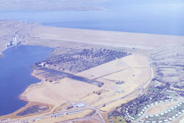 The Corps of Engineers Fort Peck Dam, originally authorized in 1933, became integral to the Missouri River flood control and irrigation storage programs. |
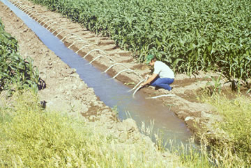
Six mainstem Missouri River dams were constructed at a cost of $1.2 billion. By 1987 the Corps of Engineers estimated that over $2.7 billion in flood damage had been prevented by them. Tonnage transported on the Missouri River from Sioux City to St. Louis also increased from about 51,000 in 1951 to about 3,261,000 in 1979, yielding navigation benefits estimated to average $17.7 million per year. Irrigated lands were producing crops with an annual gross value of $158 million in 1996. In the drought year of 1981 the reservoirs prevented damage of over $67 million. |
 |
The last of the mainstem Missouri River dams came into operation in 1964, yielding a total storage capacity of over 75 million acre-feet (that is, enough water to cover over 117,000 square miles to a depth of one foot). Following enactment, recreational and conservation purposes were added to the project and new tools for economic, hydrologic, and soils analysis were developed and applied, so that by 1958 the plan called for only 3.8 million acres of new and supplemental irrigation and an increase to 2.4 million kilowatts in hydroelectric capacity. |
Municipal and industrial water supply, sediment abatement, fish and wildlife enhancement, and pollution control purposes have since been added to the project. In 1970 Congress passed legislation to recognize the two farsighted individuals who spearheaded the planning by changing the project's name to the Pick-Sloan Missouri Basin Program. Overview of the Pick-Sloan Missouri Basin Program (5.69MB PDF) |
|