- Reclamation
- Missouri Basin and Arkansas-Rio Grande-Texas Gulf
- Multimedia
- The Huntley Project's Rocky Childhood
The Huntley Project's Rocky Childhood
American lives, a famous writer once said, have no second acts. Luckily for the Huntley Project, the same thing is not true for irrigation projects. Huntley's early years were a constant struggle: high repayment costs constrained it at birth, and drainage and other technical ills dogged its early operation. When the project seemed at last to be finding its feet, commodity prices and land values crashed.
Huntley Project
Huntley was one of the U.S. Reclamation Service's first irrigation projects in Montana, and was only the second Reclamation project completed. It lies along the Yellowstone River about 10 miles northeast of Billings. Over the ages, the Yellowstone River carved a natural path across eastern Montana, fought over by the Crow, the Northern Cheyenne, and the Sioux. Not surprisingly, Northern Pacific Railroad surveyors found the river valley the best route through eastern Montana. By 1882, the railroad had claimed free land along the Yellowstone, platted a town of 20,000 people, and named the place after the railroad director who secured the rights-of-way across the state.
Even completion of the railroad was no guarantee, however, that the town and surrounding region would prosper Indeed, by 1900 (nearly two decades after its founding) the Census recorded only 3,221 people in Billings. Boosters saw the need for further development to encourage trade and to entice people to settle in the region. Their eyes lit on unfarmed lands on the south bank of the Yellowstone, where successful farms nearby attested to the possibilities.
That these lands had been part of the Crow Reservation since 1874 was not seen as a problem.
Sentiment existed in Congress to assign Indian families 160 acres (or so) of reservation land, and open up the rest for homesteading. The Crow might have been our steadfast allies in wars against other tribes, and they might have made the transition from hunting buffalo to farming (even practicing irrigation on a minor scale). Still, they were not to stand in the way of progress – the Tribe sold the land.
Surveys led to Reclamation declaring an irrigation project possible. Building a canal and distribution system would cost an estimated $30/acre, in comparison to the going price of $100/acre for improved farmlands nearby. The land was suitable, water plentiful, growing season long enough, and Billings provided an excellent local market: signs for a project were thus auspicious. Congress authorized the Huntley Project April 18, 1905, the fifth Reclamation project to be authorized. It was to irrigate up to 35,000 acres beginning in 1907, at a cost of $900,000. Project acreage, completion date, and the construction cost were all to prove inaccurate, haunting the project in the early days.
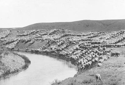
Sheep along the Huntley Project
In the original plans, water was supplied directly into the headworks of a 20-mile long main canal, and sluice ways 2 miles below the headgates regulated flows; no diversion dam or storage reservoir was thought necessary. The gravity canal was to have an initial capacity of 730 cfs (cubic-feet/second). A channel from Pryor Creek, 2 miles downstream of the headworks would also supply water to the main canal. The headgates were to be reinforced concrete with two steel gates.
Excavation of the main canal was divided into thirds for the Pryor Division, the first division of the Huntley Project scheduled for completion. Segment one, from the headworks to the Pryor Creek overpass, proved to be the thorniest to build. It involved boring three tunnels 9.2 feet wide by 9 feet high through the Huntley Bluffs to avoid the Northern Pacific's tracks along the river. Reclamation later had to move the canal further away from the tracks. This meant increasing the length of the tunnels to an aggregate of 2,650 feet. Work was complicated by the defaulting of all the sub-contractors the first year, and by standing water in the tunnels from floods the second year. The tunnels weren't completed until May, 1907.
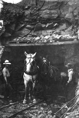
Horse drawn trolleys at Huntley Project
Excavation was by fresnos, a wheelbarrow-sized scraper pulled by a team of horses, and slip scrapers and wheel scrapers. Finish work was done by pick and shovel (although a steam shovel was used on a particularly deep cut just south of the town of Huntley). The main canal was earthlined, except at canal crossings (and other raised sections) where it was lined with concrete.
At Mile 14 on the main canal, a pumping plant was built. It housed two vertical turbines directly connected to 20-inch centrifugal pumps, employing power from a 35-foot drop in the main canal to lift 98 cfs through a total dynamic head of 48.5 feet into the High Line Canal. This 6-mile long canal conveyed water to about 5,000 otherwise nonirrigable acres south of the main canal. Pumps were installed in 1907 and successfully tested the following year.
Main canal segments two and three were completed by October, 1907. When done, the main canal crossed the original channel of Pryor Creek eight times. A 1,500-feet long concrete-lined channel was added to the facilities to avoid problems with this stream. It carried water over the main canal directly into the Yellowstone, bypassing 2-3 miles of old channel.
The laterals – smaller canals to convey water from the main canal to the fields – caused problems of their own. Reclamation's original plan was to deliver water to the high point of each farm, with a system of ditches to drain off excess water. About 165 miles of laterals were originally planned, with 65 miles of drainage ditches. Excavation was by slip scraper and an elevated grading machine. The firm awarded the contract in 1906 defaulted within the year, a victim of a labor shortage and severe winter weather. About 15 more miles of drainage ditches were needed than planned for, and they had to be dug through tightly-compacted gravel soils. Reclamation had to assume control of the work, completing it in October 1907.
Despite these difficulties, the Pryor Division was completed by 1908, a year later than originally planned. (The Eastern and Fly Creek Divisions, begun in 1906, were finished in 1914 and 1915). Because of problems and delays, the construction cost grew to $1,600,000, 44% more than the original estimate. This meant higher annual repayment costs for irrigators: a $3 construction charge (paid in installments for 10 years), plus $4 to pay the Crow for the land, with another $.60 operating expenses for the first year of operation.
President Theodore Roosevelt opened the Huntley Project for homesteading May 21, 1907. Perhaps affected by the thought of peopling the region with yeoman farmers, Reclamation estimated that 40 irrigated acres with pasture and woodland adjoining (up to 160 acres) would be enough to support a family. Thus, 28,921 project acres could provide for 585 small farms.
Public reception to the project was overwhelming, 5,491 people filing for land by the June 25, 1907, deadline. Numbers were assigned to applicants for a drawing for selecting lands. Many of the applicants came from Billings, however, and most of these filed only to see what number they would draw. They used their numbers in a local lottery--they had no desire to farm. Only 76 of the first 1,000 applicants went though the whole filing process. The result was the Huntley Project got off to a slow start, even when land was opened for unrestricted entry. Only 4,100 acres were irrigated during the first irrigation season of 1908.
Growth, while slow, was at least steady to begin with. Farm population increased from 783 in 1908 to 2,107 by 1917. Value of the crops per acre increased by nearly a third to $36 in the same time span.
Then the bottom fell out: the end of World War I saw the European commodity market disappear, which, compounded by several years of poor weather and higher costs for labor and seed, devastated the project. The value of crops per acre dropped by 40% between 1918-1922, and population decreased by more than half.
Good crop years beginning in 1923 and rising crop prices helped the surviving irrigators. Individual farms grew in size to more economical units as abandoned project lands were acquired. The irrigators formed the Huntley Irrigation District in 1921, and were soon operating and maintaining the project on their own. Their contract with Reclamation in 1927 resolved long-time disagreements about drainage, repayment, and other issues which had inhibited growth.
Reclamation expanded the Huntley Project by canal extensions and adding an auxiliary pumping plant. The main canal was extended to its final length of 32 miles and two new canals were built. Extension of the main canal in 1914-1915 opened 1,815 acres for irrigation east of Pompeys Pillar in the Eastern Division of the project. Built between 1915-1917, the 4.4-mile long High Line Extension Canal and the 9.2-mile long Reservoir Line Canal irrigated another 2,079 acres and 2,000 acres, respectively, in the Fly Creek Division. The auxiliary pumping plant was build on the main canal near the original plant in 1917-1918. It allowed the capacity of the main canal to be increased from 60-100 cfs, providing more water for irrigation.
Continuing problems with drainage caused 1,000 acres in the Pryor Division to be waterlogged by 1913, with another 8,000 acres in danger of becoming waterlogged. The 80 miles of drainage ditches in the project were insufficient, a problem made worse by excess seepage from the canals, over watering of crops, and neglect of the existing ditches. Irrigators wanted Reclamation to clean out deteriorating drainage ditches and build new ones, which the agency refused to do without a repayment contract. Funds at last were found for 502 miles of closed tile drains and 152 miles of open drains, which alleviated the problem by 1920. The Eastern and Fly Creek Divisions experienced similar problems, however, and the dispute between irrigators and Reclamation over the problem was not to be resolved until 1927.
After some years of operation, it became plain that the natural flow of the Yellowstone did not convey enough water into the main canal, especially in dry years. The District built a temporary earthfill diversion dam about 1,000 feet downstream of the headgates in 1931. This dam was replaced by a 102-foot high concrete weir in 1934, with a crest length of 325 feet. A 6-foot diameter underground concrete pipe conveyed water to the main canal.
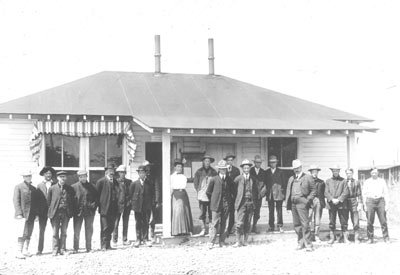
Early Reclamation Service Engineering Office
The last facility added to the Huntley Project was Anita Reservoir in 1936-1937. Built by the Civilian Conservation Corps, the earthfill dam is 42-feet high with a crest length of 1,008 feet. The 400-acre-foot reservoir behind the dam reduced the need for the auxiliary pumping plant, which proved expensive to operate. Water is pumped to the reservoir from the High Line Canal in slack periods to supplement the water supply during times of heavy demand.
By 1949, the Huntley Project's growing pains were a thing of the past. The project provided 188,765 acre-feet of water that year, more water than it had ever delivered before, to serve 24,385 acres on 657 farms. Value of crops per acre equaled $61. The farm population reached 1,492, with another 793 people in towns spawned by the project--Huntley, Worden, Ballantine, and Pompeys Pillar.
Huntley had survived its rocky childhood to hit its stride in maturity.
For additional information on Huntley Project and other projects see our facilities pages.
Photos in Full Size
1. Horse-drawn trolley in tunnel.
2. Sheep along the main canal.
3. Reclamation Service's Engineering Office.
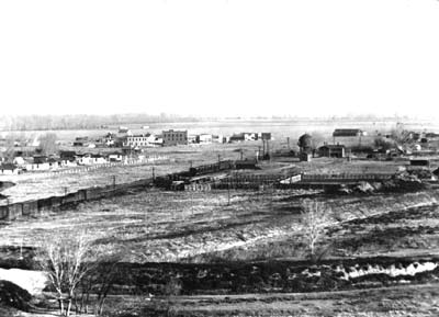
4. Overview of Huntley, showing government housing, hotel, and livery stable along the railroad tracks.
