- Reclamation
- Missouri Basin and Arkansas-Rio Grande-Texas Gulf
- Multimedia
- Palmetto Bend Dam & Reservoir, Texas
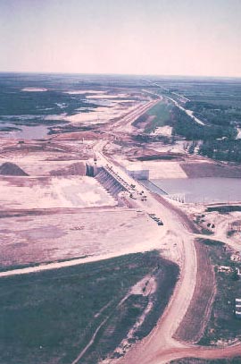
Aerial view of the spillway and maximum dam section facing east. Note the river diversion on the far side of the concrete
spillway section. Photo April 8, 1980.
Palmetto Bend Dam & Reservoir, Texas
The history of the Missouri Basin Region of the Bureau of Reclamation is as diverse as its landscape. Projects at the south end of the region came later in Reclamation's development of water resources in the West. Although more recently constructed, these facilities encompass lands with a past that is just as colorful as the older facilities to the north. An example of this is Palmetto Bend Dam near Edna, Texas.
Like all Reclamation facilities, Palmetto Bend Dam was the result of western settlement and development of the West. Before this occurred the area was the home of the Karankawas. These native people were a hunting and gathering society that found their livelihood from both the land and sea along the coastal plain.
Nearby Matagorda and Lavaca bays and the Lavaca and Navidad river valleys provided nomadic family-based bands of people with much of their food. They were patrilineal and the size of their bands varied with economic prosperity. The Karankawas are remembered today in the Rockport pottery of the Texas gulf and their use of asphaltum to decorate pottery.
The first known White settlement occurred in 1685 when the French Explorer LaSalle established the ill-fated Fort St. Louis on Lavaca Bay. Several missions and presidios were established in the area between 1718 and 1795. The Spanish constructed them to prevent any further French landings while furthering their own interests. By 1821, three hundred years after white men set foot in Texas, only three outposts remained between the Sabine and Rio Grande Rivers. San Antonio and Goliad in the San Antionio River Basin and Nacodoches in east Texas. The white population of Texas was not more than 7,000 of which most were Spanish.
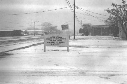
An unusual event in the Palmetto Bend area: snow. This snowfall occurred on
January 11, 1973, during the construction of the dam.
The first permanent Anglo-American settlement in the area was the result of Mexican land grants to Stephen F. Austin and Green De Witt. Jackson County was settled in 1831, three years before the town of Texana was established. Texana became the Jackson county seat from 1835 to 1883 and was located near the Palmetto Bend Reservoir site.Also nearby was Camp Independence.
This camp served as a bivouac for a portion of the First Texas Army under the command of General Felix Huston and later General Albert Sidney Johnston. Camp Independence was occupied for six months until the army was disbanded by order of President Sam Huston in May, 1837. The last days of the Texas Republic saw the beginning of German settlement in south Texas. Their numbers swelled the combined population of Jackson and Lavaca Counties to 2, 567 in 1850.
Transportation was an important factor in the early development of the coastal plains. The first stage line came in 1861. Texana was a busy and prosperous seaport with twenty vessels calling weekly by 1880. However, conflicts with Mexico and civil and Indian strife inhibited further settlement until after the reconstruction period following the Civil War. The upsurge of railroad construction in the 1880's brought renewed settlement and stability to the area, but Texana was bypassed by the New York, Texas, and Mexican Railway Company in 1883 and a new county seat was established at Edna. By 1884 the township was virtually deserted and evidence of the existence of Texana rapidly vanished.
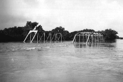
The Southern Pacific Railway and one U.S. Highway 59 bridge at the Navidad River near
the dam site on June 15, 1973. The
dam was built to limit future flood damage.
Continued development through the middle of the next century depended upon agriculture. The railroads had limited the demand for coastal ports and shipping. Cattle, sorghum, rice and cotton added to the fish and shrimp harvested from the gulf as exports. Manufacturing and industry lagged behind neighboring counties. One of the critical needs of the area was deemed to be a water supply of sufficient quality and quantity to support continued growth of communities and the industries that would support economic growth.
State and local officials repeatedly petitioned for a project to provide for these needs. At the same time, flood control became an important issue. The Texas Legislature formed the predecessor to the Lavaca-Navidad River Authority in 1941 as a county flood control and reclamation district.
Federal development began with studies for a dam (originally Texana Dam) which were completed in 1960 with plans to possibly construct it at a later date. In September, 1961, Hurricane Carla caused heavy damage to the already economically disadvantaged area.
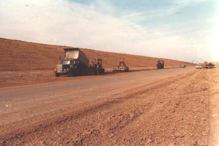
A view of contractor beginning the placement of the three foot slope protection (soil
cement) on the upstream side of the
maximum dam section on March 13, 1980.
It was determined that the construction of the reservoir at the earliest possible date was the best way to provide assistance in recovering from the hurricane. As a result, feasibility studies and a series of congressional hearings over several years resulted in the project being authorized on October 12, 1968. By 1972 construction was underway in preparation for the dam. The reservoir was filled in 1980 and the project substantially complete by 1982.
