- Reclamation
- Missouri Basin and Arkansas-Rio Grande-Texas Gulf
- Montana Area Office
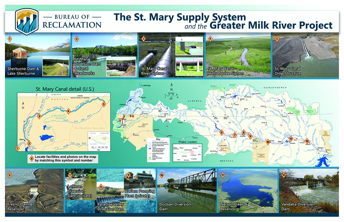
- St. Mary Diversion Dam and Canal
St. Mary Unit Projects
Overview
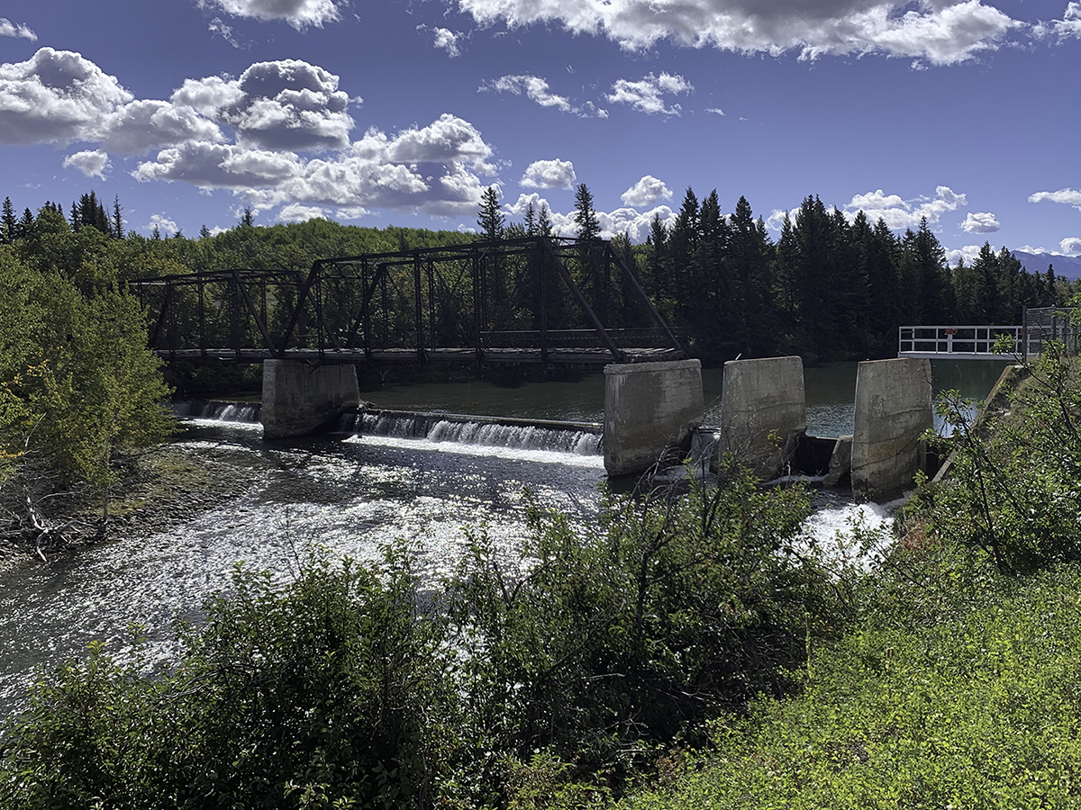
The St. Mary Diversion Dam and Canal were completed in 1915 as part of the Milk River Project (Project) in north-central Montana. The dam is located near Babb, MT and approximately 0.75 miles downstream from Lower St. Mary Lake. The existing dam consists of a 198-foot long and 6-foot-high concrete weir and sluiceway. It diverts water from the St. Mary River into the St. Mary Canal through the gated headworks structure for use by the Milk River Project in accordance with the Boundary Waters Treaty division of waters between the U.S. and Canada assuring water supply and viability of irrigated agriculture on the Milk River Project. Much of the dams existing structural components are dilapidated and in need of replacement.
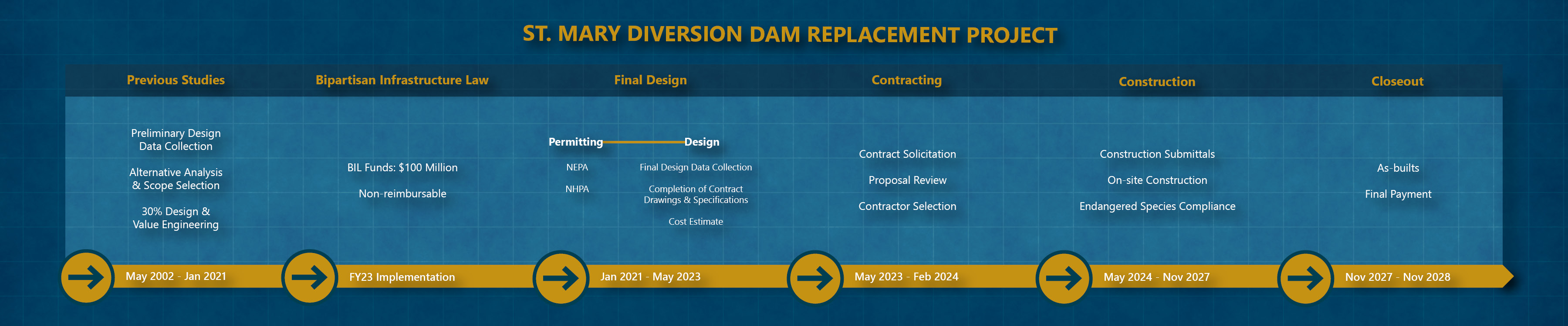
The St. Mary Diversion Dam Replacement Project will include all activities required to design, construct, and closeout construction of a new diversion dam and fish protection structure that will comply with the Endangered Species Act (ESA). The main features of the project will be a low head diversion dam and rock ramp for upstream passage, a new headworks structure, a canal fish screen, a check structure downstream of the fish screen, a fish bypass to return fish to the river, O&M and control buildings, and auxiliary features.
The Infrastructure Investment and Jobs Act (IIJA) has set aside $100M directed to facilities that have failed in the last two years, in a way that prevented delivery of water for irrigation. As written, the St. Mary Diversion Dam and Canal is the only project to fit these criteria. The $100M does not require reimbursement by the Milk River Project water users and will be used to fund the replacement of the St. Mary Diversion Dam and Headworks.
The primary stakeholders on the Project are the Blackfeet Nation, the U.S. Fish and Wildlife Service, and the eight irrigation districts that make up the Milk River Irrigation Project Joint Board of Control (Joint Board). Other stakeholders include over 150 pumpers along the Milk River and six municipal entities.
A computer generated aerial view of new and existing features of the St. Mary Canal and Diversion Dam. The St. Mary Diversion Dam and Canal were completed in 1915 as part of the Milk River Project in north-central Montana. The dam is located near Babb, Montana and approximately 0.75 miles downstream from Lower St. Mary Lake.
Current Status
The St. Mary Diversion Dam Replacement Project was awarded to NW Construction, Inc. out of Bozeman, MT (SAM.gov). The project, which is located near Babb, MT, began on-site work for the replacement of the existing diversion/headworks in July of 2024. The project is anticipated to be completed in the fall 2028. The construction seasons of 2024 and 2025 saw the site developed, temporary by-pass canal constructed, dewatering system installed, and excavation and concrete placement for phase 1 (headworks structures) completed. After a brief winter shutdown, the 2026 construction season will bring the removal of the old bridge structure and phase 2 excavation and concrete placement.
Endagered Species Act (ESA)
In 1999, the U.S. Fish and Wildlife Service (Service) listed Bull Trout (native to the Saint Mary River) as a threatened species. The Service concluded that Bull Trout are negatively impacted by the Diversion Dam by acting as a passage barrier and entrainment in the canal. The current dilapidated structural components of the dam and the lack of fish passage and screening are the main reasons for this dam replacement and modification project.
Reclamation entered formal consultation with the Service through submittal of a Biological Assessment (BA) on April 24, 2020 on current O&M. The BA action area includes the entire St Mary Unit from Lake Sherburne to the terminus of the St Mary Canal at the North Fork Milk River. The Service issued a Biological Opinion (BO) and Incidental Take Statement (ITS) September 4, 2020. The BO included three Reasonable and Prudent Measures (RPMs) that are nondiscretionary:
- RPM #1: Implement measures to reduce the direct loss of bull trout due to entrainment into the canal.
- RPM #2: Implement measures to reduce the likelihood of bull trout stranding in Swiftcurrent Creek.
- RPM #3: Continue assessing, developing, and implementing measures designed to reduce the direct loss of bull trout associated with the operations of the St Mary Unit, Milk River Project.
Reclamation will consult with the Service on this proposed action’s effects on threatened and endangered species. This project will directly address RPM’s #1 and #3.
History
The Milk River Project (Project) was authorized for construction by the Secretary of the Interior on March 14, 1903, as one of the first five projects authorized under the Reclamation Act of June 17, 1902. Project features include Lake Sherburne, Nelson, and Fresno Storage Dams; St. Mary, Paradise, Dodson, and Vandalia Diversion Dams; Dodson Pumping Plant; and hundreds of miles of canals, laterals, and drains.
As part of Reclamation’s Milk River Project, the St. Mary Diversion Dam was constructed by Reclamation in the early 1900s to divert flows from the St. Mary River to the Milk River Basin. The St. Mary Unit facilities include Lake Sherburne Dam, Swiftcurrent Creek Dike, St. Mary Diversion Dam and Canal Headworks, and the St. Mary Canal. The 29-mile long canal, located entirely within the exterior boundary of the Blackfeet Indian Reservation, transports water from the Hudson Bay drainage to the Missouri River drainage. Most of the water supply for the Project originates in the St. Mary River watershed and provides water for the irrigation of approximately 110,000 acres on eight irrigation districts, approximately 150 individual pumpers, several communities in northcentral Montana, and the Bowdoin National Wildlife Refuge.
The waters of the St. Mary and Milk Rivers are shared between Canada and the United States under Article VI of the Boundary Waters Treaty of 1909 and the 1921 Order of the International Joint Commission.
Click here to view the Boundary Waters Treaty
Click here to view the 1921 Order
There have been a significant number of studies completed and decisions made to choose the preferred alternative of a rock ramp and fish screen. Throughout the process the primary stakeholders participated at nearly every step. While not a comprehensive list, the following reports have been developed:
Map
Active Participants
Blackfeet Nation
Milk River Irrigation Project Joint Board of Control
- Alfafa Valley Irrigation District
- Dodson Irrigation District
- Fort Belknap Irrigation District
- Glasgow Irrigation District
- Harlem Irrigation District
- Malta Irrigation District
- Paradise Valley Irrigation District
- Zurich Irrigation District
Municipalities
- City of Havre
- City of Chinook
- City of Harlem
River Pumpers
United States Fish and Wildlife Service
Bureau of Indian Affairs, Blackfeet Agency
St. Mary Rehabilitation Working Group
Project Documents
Project Timeline
Watershed Planning
Contract Documents
Point of Contact
Project Manager
(406) 247-7322
sdarlinton@usbr.gov
Bureau of Reclamation
Montana Area Office
P.O. Box 30137
Billings, MT 59101
(406) 247-7300
