- Reclamation
- Missouri Basin and Arkansas-Rio Grande-Texas Gulf
- HydroMet
- Snowpack & Reservoir Levels, More Information
Snowpack & Reservoir Levels, More Information

EXPLANATION OF LEGEND LABELS:
Facility Name: Name of dam or reservoir.
% total capacity – Percentage of total storage capacity used by water currently stored in the reservoir.
% daily historical average – Amount of water currently stored in the reservoir, as compared to historical levels on this date (25-year average).
Total Capacity in thousands of acre-feet (kaf) – Total capacity of the reservoir in thousands of acre-feet* (kaf) <more information>.
Flood (control) capacity in thousands of acre-feet (kaf) – Reservoir capacity allocated to the sole purpose of regulating flood inflows to reduce flood damage downstream <more information>.
Outflow in cubic feet per second (cfs) – This is the total discharge from the reservoir including releases from the river outlet works, canal outlet, municipal outlet, power plant, spillway, and any other releases which might apply.
% daily historical average snowpack – Current snowpack (in snow-water equivalents) as compared to historical levels on this date (10-year average)
- For more information on how capacities are allocated at individual reservoirs, please see our reservoir allocation page.
- For individual reservoirs, see Lakes & Reservoirs.
- For more information about dams and power plants, see Projects & Facilities.
*An acre-foot = 325,851 gallons, or the amount of water needed to cover 1 acre (43,560 square feet) 1 foot deep.
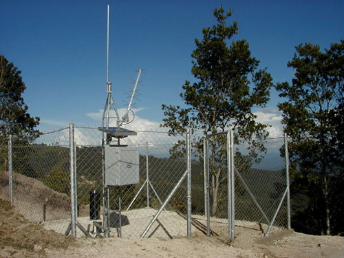
An example of an automated hydrologic and meteorologic monitoring (HydroMet) station that are located throughout the Great Plains Region.
