- Reclamation
- Missouri Basin and Arkansas-Rio Grande-Texas Gulf
- Multimedia
- Lewis and Clark: The Waterway to the West
Lewis and Clark: The Waterway to the West
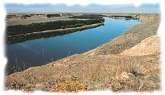
The Missouri River in Montana – Photo courtesy of Travel Montana
The journey up and down the Missouri River was to comprise 5,000 miles of the expedition's total mileage of 8,000. It was their waterway north and west across the territory called the Louisiana Purchase, land the United States had recently purchased from France for $15 million, and which doubled the size of the country.
It was this land that President Jefferson saw as key to the westward expansion of the United States. It would link the land to the east and the "Oregon Country," which had previously been claimed by the United States.
Jefferson was among those who dreamed of a Northwest Passage - one river or a series of connected rivers that would cross the western mountains and reach the Pacific Ocean. Was the Missouri River the key to this legendary Northwest Passage?
Like the French and Spanish explorers who had begun their exploration of this river some 300 years before, President Jefferson hoped so. Lewis and Clark were well on their way to finding this out.
As they traveled further north and west every day, the experiences of this Corps were inextricably linked with the water that moved them along their course.
Near a village of Omaha Indians close to present-day Sioux City, Iowa, Clark wrote about a successful fishing trip. "I went with 10 men to a creek damed by the beavers about half way to the village. With some small willows & bark we made a drag and hauled up the creek, and cought 318 fish of different kind i.e. pike, bass, salmon, perch, red horse, small cat, and a kind of perch called silver fish on the Ohio."
President Jefferson also directed the Corps of Discovery to inform all the inhabitants they met of the acquisition by the United States of the land in the Louisiana Purchase. They did this in meetings with each Indian tribe along the way, their first official one occurring north of present-day Omaha, when they met with a small delegation of Oto and Missouri Indians. During the Corps' first meeting with a Sioux tribe, a grand council was held with the Yankton Sioux at a site below Calumet Bluff, near present-day Yankton, South Dakota.
Food in Abundance
It was here they encountered an abundance of food sources - they shot their first buffalo and feasted on deer and elk. The plums, grapes and buffalo berries were abundant. And here the captains recorded their first-ever scientific description of a pronghorn antelope.
In the following days they encountered bluffs along the river that appeared to be on fire. Smoke and steam pouring out of the earth's surface created the look of a fire without the flames that can still be seen on a rare occurrence today.
They arrived at the Grand Detour or Big Bend region on September 30, which is south of present-day Pierre. They set up camp on a sandbar along the river. Early the next morning, as they were sleeping, the sandbar started to give way. Quickly loading their boats, they shoved off just as their campsite tumbled in to the water.
During the next three weeks, they encountered Dakota and Teton Sioux (also known as Lakota) and Arikara encampments.
Their meeting with the Tetons was not as cordial as it had been with the Yanktons. The Tetons demanded one of the Corps' boats as a toll for moving further upriver. In what was to be a three-day standoff, the Teton stood in ranks on the bank of the Missouri River as they prepared to fire arrows down upon the expedition. Expedition members aimed back with their swivel guns. This show of force, perhaps even more importantly, the diplomatic intervention by Teton Chief Black Buffalo, diffused the standoff and allowed the Corps to move further up the river.
On October 8, they spent several peaceful days at an Arikara village. The Arikara were especially fascinated by Clark's black servant, York, who enjoyed the attention.
It was October 14 when the expedition entered what today is North Dakota, camping near the mouth of Four Mile Creek, five miles south of today's town of Fort Yates and meeting more Arikara. A convincing sign of winter came a week later when the first snow fell. They reached their winter camp destination of the Knife River Indian Villages on October 26.
Well accustomed to white visitors, this hub of fur trade commerce in the Upper Missouri welcomed the Corps of Discovery. The welcoming nature of the Mandan and Hidatsa people, as well as the gifts they were given, won over the earth lodge people. Sheheke or Big White, the chief of the lower Mandan village, told Lewis and Clark: "Our wish is to be at peace with you... If we eat, you shall eat; if we starve, you must starve also."
Fort Mandan Winter
Clark chose to locate Fort Mandan on the east bank of the Missouri River, at a distance from all the villages so the fort would not be associated with any one particular Indian village.
Throughout their winter at Fort Mandan, the explorers prepared for the next leg of their journey. In early April they sent a crew downstream in keelboats back to St. Louis. The boats were filled with letters, journals, reports of their scientific and geographical gathering, Indian artifacts and vocabularies and hundreds of mineral, botanical and animal specimens. Among these animal specimens were a living prairie dog and a magpie. These materials were to be delivered to President Jefferson.
Those remaining at Fort Mandan, a group of 32 people and Lewis's dog, a Newfoundland called Seaman, launched six canoes and two pirogues and "proceeded on" northwest on the Missouri April 7, 1805. With them were French-Canadian trader and interpreter Pierre Charbonneau, his wife Sakakawea, a 15-year-old Shoshone who had been captured by the Hidatsa a few years earlier near the Three Forks area of present-day Montana. The youngest member of the Corps was their baby Jean Baptiste, born that February and nicknamed "Pomp." (Sakakawea, which means "bird woman" in the Hidatsa language, is also referred to as Sacagawea or Sacajawea.)
During this Fort Mandan winter, Lewis and Clark had asked many questions about the upper Missouri and what was ahead. Maps had up until now guided them. Now going forward without maps, they carefully listened to what the Indians and trappers told them to expect. Much, but not all, of this information was helpful and accurate.
On April 7, 1805 - upon leaving Fort Mandan Lewis wrote: We were now about to penetrate a country at least two thousand miles in width, in which the foot of civilized man had never trodden; the good and evil it had in store was for experiment yet to determine.
Spring was upon the Upper Plains and the river water was high. Clark recorded in his journal seeing buds on the maple, elm, arrowwood and cottonwood trees. The mosquitoes, which were to torment them throughout their time on the water, were also back. Six days after their departure, they neared the mouth of the Little Missouri River in present-day northwestern North Dakota. A strong wind began blowing, making the waters rough. Both captains were on shore when this squall struck and nearly dumped the precious cargo of supplies, trade goods, journals and maps that were on the boats. Charbonneau was at the helm and panicked when the near accident took place, making matters worse. Sakakawea, on the other hand, kept a level head and is credited with salvaging many items valuableto the expedition.
A Spring Launching
Strong winds and cold temperatures challenged the Corps as it moved toward the confluence of the Missouri with the Yellowstone River in late April. They noted that this confluence, situated on today's North Dakota-Montana state line, would be a good place to build a fort. It was to be regarded later in the century as one of the river junctions most influential to westward expansion. Onward they proceeded, into what is present-day Montana.
On May 8, the Corps came upon a tributary river that had a cloudy appearance. Lewis named it appropriately the Milk River, which is located near present-day Glasgow, Montana. Moving westward, they began to detect changes in the land. The prairie grassland of the Great Plains they had traveled across since entering present-day South Dakota was disappearing. Sagebrush and pines were appearing, and the first big horn sheep were sighted.
On May 31, they came upon one of the Missouri River's most strikingly beautiful areas, today known as the White Cliffs of the Missouri, and located near the present-day town of Havre, Montana. Lewis wrote a lengthy description of these bluffs, describing how water had shaped them into "a thousand grotesque figures, pyramids, and lofty, freestone buildings their parapets well-stocked with statuary... so perfect indeed are those walls that I should have thought that nature attempted here to rival the human art of masonry had I not recollected that she had first begun her work."
A Fork in the Road of Water
A few days later, they arrived at a fork in their road of water. Two great rivers came together, and the captains were faced with the decision of choosing the correct route. The mountains were somewhere in front of them to the west. But they had seen small ranges north and south, too. Despite scouting ahead, it was not clear which was the Missouri or, more importantly, which river would take the Corps to the Pacific Ocean. It would be a critical decision. The crew was of one mind that the north fork was the way. The two captains, after many debates, chose the fork to the south. The water to the north they named the Marias River, after Lewis's cousin Maria Wood.
Had they chosen the correct fork? They believed so when Lewis heard the Great Falls of the Missouri River on June 13. The Hidatsa had told them they were on the correct route if they found a big waterfall. At the Great Falls they found not one cascade of water over rock, but five. To cross it, the expedition had to make a difficult, nearly 20-mile portage over land that would cost them a month of valuable time.
The expedition celebrated the Fourth of July 1805 at the Great Falls. Their route up the Missouri River at the Great Falls moved southwest, not west toward the mountains. Then, as they passed through the Gates of the Mountain on July 19, west of present-day Helena, Montana, the river began its sweep to the south and to Three Forks. Here the three rivers they named the Jefferson, Gallatin and Madison come together to form the Missouri River, and they could see the intimidating peaks of the Rockies. With the view of these mountains ahead, the explorers were concerned about how they would cross them.
Three Forks was where Sakakawea had been kidnapped years before by Hidatsa warriors. Here she began to recognize familiar landmarks, but the Shoshone were not there. The Corps chose the narrow and rocky Jefferson River as its next waterway, slowly moving ahead, all along battling intense currents and icy river twists.
They made a decision to split up, with Lewis and three other men mounting a land search for the Shoshone, leaving Clark and the others to continue to navigate the Jefferson. On August 11, Lewis saw a lone mounted Indian, the first the expedition had seen since leaving Fort Mandan. The Indian rode off as Lewis tried to make contact with him, and two days later he found a larger group of Shoshone. On August 12, Lewis became the first white man to cross the Continental Divide.
At the Continental Divide, Lewis began to grasp that a crucial mission of the expedition would not be realized. The explorers and President Jefferson had hoped that the source of the Columbia River would be nearby - the last link of the Northwest Passage they dreamed existed. Instead of another river, Lewis faced a wall of mountains standing between himself and the Pacific Ocean. At that point, he knew there was no easy water route to the Pacific, at least using the Missouri River.
The next 10 months were to test the character and determination of the Corps of Discovery to degrees that had not yet been experienced. In what has been called one of the country's greatest historical coincidences, the chief of the Shoshone tribe they met was Sakakawea's brother, Cameahwait. This reunion with her brother, which took place at Camp Fortunate, the present location of Clark Canyon Reservoir. The meeting brought assurance that the Corps would be met with peace and cooperation.
Two weeks later, they were traveling north overland, with 29 horses, 1 mule and a Shoshone guide named Old Toby. They traveled over a mountain pass and into the Bitterroot River Valley. Proceeding on out of present-day Montana over the Bitterroot Mountains, they were back to water travel when they reached the Clearwater River near what is now Orofino, Idaho. With the river's current at their back for the first time, they swiftly moved down the Clearwater and the Snake Rivers, reaching the Columbia October 16, 1805. They wintered at the south side of the Columbia near present-day Astoria, Oregon, building Fort Clatsop.
Their return trip east began on March 23, 1806, taking again the Columbia and Clearwater river routes that had brought them west. On April 21, they left the Clearwater and continued overland. Twelve days later, the last of the dried meat and dogs were divided among the party. On May 4, the Corps was reunited with the Nez Perce, the people they first met on their trip west.
Because it was too early to cross the snow-filled passes through the mountains, they stayed with the Nez Perce until June 24. Continuing their journey, they traveled 156 miles in six days to Traveler's Rest, only half the time it took to cover the same ground on the way out. They credited this improved time to better guides and not getting lost.
Still holding out a glimmer of hope that a Northwest Passage could be found, the Corps divided into two groups. Clark and his group headed southeast to the Yellowstone River traveling across Shoshone lands. Again, Sakakawea provided valuable guide services, pointing out Indian trails that led to the Yellowstone. Clark and his party once again made dugout canoes and explored the river downstream to its confluence with the Missouri. Despite this rather complicated return trip, they met up with each other at Reunion Bay on August 12, just two days shy of the Knife River.
Reaching the Mandan villages meant safety, food and shelter and a reunion with friends made during the 1804-5 winter. The captains paid Toussaint Charbonneau for his horse, teepee and services – some $500, with no compensation for Sakakawea. After a three-day stay, the remaining members of the Corps of Discovery, along with Mandan Chief Sheheke, pushed off for St. Louis.
On this return trip south, they again marveled at the spectacle of abundant wildlife they had seen on their trip. On August 29, in present-day South Dakota, Clark wrote, "I assended to the high country and from an eminance I had a view... of a greater number of buffalow than I had ever seen before at one time. I must have seen near 20,000 of those animals feeding on this plain."
The Corps of Discovery pulled into dock at St. Louis on September 23, 1806, greeted by cheers from a large crowd. Two years, four months and 10 days had passed since they had left there, and many had given up any hope of seeing them again. They had covered more than 8,000 miles and had seen sights and set foot where no American had ever been before.
Lewis and Clark may not have discovered a direct Northwest Passage, but they did forge a path to the Pacific that would inspire thousands of others to settle in the northwestern United States in the century to follow.
