- Reclamation
- Missouri Basin and Arkansas-Rio Grande-Texas Gulf
- Multimedia
- Lewis and Clark: Early Projects and their Impacts
Lewis and Clark: Early Projects and their Impacts
The heyday of Reclamation construction of water facilities occurred during the Depression and the 35 years after World War II.
Today, Reclamation operates about 180 projects in the 17 Western states. The total Reclamation investment for completed project facilities exceeds $11 billion. These projects provide agricultural, household and industrial water to about one-third of the population of the American West.
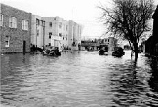
A 1930s Upper Missouri River flood. (State Historical Society of North
Dakota 0497-017)
It was not always this way. In its early days, the Missouri was unbridled and wild. This did not go unnoticed with those who wrote about their encounters with the river. Father Pierre Jean DeSmet, who was otherwise considered to be a brave man, expressed his terror of the river with these words: "I fear the sea, I will admit, but all the storms and other unpleasant things I have experienced in four different voyages did not inspire so much terror in me as the navigation of the somber, treacherous and muddy Missouri."
George Fitch, writing in American Magazine in April 1907, said this about the river's erratic behavior: "There are rivers of all lengths and sizes and of all degrees of wetness. There are rivers with all sorts of peculiarities and with widely varying claims to fame. But there is only one river with a personality, habits, dispositions, a sense of humor and a woman's caprice; a river that goes traveling sidewise, that interferes in politics, rearranges geography and dabbles in real estate; a river that plays hide and seek with you today and tomorrow follows you around like a pet dog with a dynamite cracker tied to its tail. That river is the Missouri.'
Settling the West
As the population of the Missouri Basin increased, the disposition of the Missouri River had a greater impact.
The settlement into the area that began soon after the Lewis and Clark Expedition of the early 1800s, and grew throughout the century.
The Homestead Act of 1862 was responsible for bringing many settlers to the area.
The Act offerred up to 160 acres of free land to anyone willing to settle and cultivate it for three years, but these "homesteaders" were soon to find that water was a key factor in their success or failure. Water became a controlling force in their lives. Their economy and their lives depended on it, but there always seemed to be either too much or too little of it.
This was especially true when the settlers moved to the regions west of the 100th meridian, which today runs roughly parallel to U.S. Highway 83. These regions were considered at best semi-arid, and farming these lands brought challenges the settlers did not experience in their previous homes further east.
While average annual precipitation ranges from eight inches in parts of the northwest plains up to 42 inches in portions of the lower basin, the central portion comprising about two-thirds of the basin receives less than 20 inches of moisture each year. The area is naturally dry, cyclic droughts, sometimes lasting for several years, made early farming efforts even more difficult.
The refrain from the song, "Dakota Land," by Carl Sandburg was popular by those northern plains homesteaders who gave up the struggle of farming in the late 1880s:
We've reached the land of desert sweet,
Where nothing grows for man to eat,
The wind it blows with fev'rish heat
O Dakota land, sweet Dakota land
As on thy fiery soil I stand,
I look across the plains
And wonder why it never rains.
Yet, even during periods of drought, the Missouri and its tributaries would flood, often with devastating consequences.
Two federal agencies were involved in the development and were given responsibility for managing water within the Missouri River Basin – the U.S. Army Corps of Engineers and the Department of the Interior's Bureau of Reclamation. In 1824 the Corps was first given jurisdiction to maintain the nation's navigable rivers in the interest of interstate commerce. Other responsibilities were later delegated to the Corps whenever navigability of the waterway was a concern.
The Bureau of Reclamation was established by the 1902 Reclamation Act and originally called the Reclamation Service. Its purpose was to enhance development of farmlands while encouraging economic development and providing economic stability in the West. The agency was to help "reclaim" otherwise unproductive lands for agricultural use through irrigation projects. From 1902 to 1907, Reclamation began about 30 projects in Western states. Some examples of early Reclamation projects follow.
The Huntley Project:
Captain William Clark of the Corps of Discovery scratched his name and the date of July 15, 1806, on Pompeys Pillar, a large rock landmark overlooking the Yellowstone River in present-day south-central Montana. Later, the Yellowstone River became a route for traders, trappers and pioneers. The earliest settlers in the district were the fur traders, then prospectors and other pioneers came to the area. Some of these people turned to agriculture, raising cattle or other pursuits, while some continued to mine. All contended with difficulties common to western pioneer life.
The Crow Indian Reservation, established under the ratified treaty of May 7, 1868, included an area much larger than the present reservation. The lands in the Huntley Project, being within the reservation, were not subject to homestead entry and consequently remained undeveloped long after other fertile tracts in the Yellowstone Valley were settled. The cession of lands to the United States by the Crow Indians in 1904 included those in the Huntley Project and opened the way for irrigation and settlement.
An act of Congress approved April 27, 1904, provided that the Reclamation Service should make surveys and investigations for the irrigation of the irrigable area lying south of Yellowstone River and extending along the Bighorn River as far southeast as the Fort Custer military reservation.
Following surveys and planning throughout 1904 and early 1905, the project was authorized by the Secretary of the Interior in April 1905. Construction began later that October and the first water was delivered in 1908.
Today the project includes a rockfill and concrete diversion dam, 32 miles of main canal, 22 miles of carriage canals, 202 miles of laterals, 186 miles of drains, a nydraulic turbine-driven pumping plant and an auxiliary electric pumping plant, both in the main canal, and an offstream storage reservoir. The project can furnish water to irrigate 27,333 acres.
Milk River:
The Milk River Valley in north-central Montana was one of the last areas in the West to be inhabited by white settlers. By the late 1880s, several small private irrigation systems had been constructed which diverted water directly from the Milk River. These systems functioned sufficiently during periods of high river flows, but the inconsistent nature of the supply threatened the stability of the area.
Only a few weeks following the formation of the federal Reclamation Service in 1902, the agency submitted for approval by the Secretary of the Interior initial plans for the construction and development of the Milk River Project. It was approved in March 1903 as one of the first five Reclamation projects, however it took another decade to resolve international water rights disputes with Canada.
Early construction began in 1907. As construction continued, adjacent lands were settled for irrigation as they were completed. By 1940, 678 farms had located on the project. This number fluctuated up and down by some 100 farms over the next several decades, and in 1992 there were 522 full-time and 102 part-time farms. The primary benefit of the Milk River Project is a reliable water supply for irrigation of as much as 120,000 acres along the Milk River.
The primary crops grown are alfalfa hay, wheat and barley. The development of the Milk River as one of the initial projects of the Reclamation Service, played an important role in the development of not only the region, but the western United States and Canada as well.
Belle Fourche:
By early 1903, inhabitants of the Belle Fourche area of northwestern South Dakota had called the attention of members of Congress and the federal government to the irrigation potential of this area just north of the Black Hills in Butte County. In French, Belle Fourche translates into "beautiful forks," in reference to the area's confluence with the Belle Fourche and Red Water rivers.
The Secretary of the Interior authorized the Belle Fourche Project in May 1904. By the spring of 1905, a site below the junction of Dry Creek and Owl Creek was selected as the reservoir location for storage of water to irrigate lands on both sides of the Belle Fourche River.
Hay and alfalfa were identified as major crops, with small grains such as oats, barley, wheat and rye and fruit as other possible crops. Enough of the project's construction was completed by 1908 for it to provide water to some 50,000 acres of land during that year's growing season. It was considered complete in 1914 and consisted of the dam and reservoir, diversion dam, 94 miles of canals and 450 miles of laterals and a diversion dam.
In 1984, the project had 397 farms with an irrigable area of 56,853 acres. The Bureau of Reclamation operated and maintained the Belle Fourche Project until January 1, 1949. After that date the Belle Fourche Irrigation District assumed responsibility for the operation and maintenance of the project. Congress authorized a $42 million rehabilitation project in 1983, and through 1998, the project has received $62.5 million in federal rehabilitation funds.
Buford-Trenton:
In November 1904, the original Buford-Trenton project was authorized by the Secretary of Interior. Designs called for the irrigation of some 11,000 acres in northwest North Dakota along the Montana Border in Williams County.
Early Reclamation attempts to irrigate the area near Buford-Trenton were met with limited success. This early project irrigated benchlands at a higher elevation through a five-mile long irrigation ditch and pipeline, which moved water from the Missouri River directly into the irrigation system. Electricity for the project came from a lignite-powered steam plant in Williston. Construction on the project was ceased in 1908, with only 38 percent of the project complete. But it did operate intermittently until 1912.
The original project was revised a few decades later, the first of the recommended Great Plains projects initiated in the 1930s to relieve drought and economic suffering. The plan was to settle 95 families on the project in addition to those already there, and the total of irrigable acreage was 14,800. Beginning in 1940 labor from the Works Progress Administration began building a construction camp and began work on the project.
Because of the war effort and labor shortages, the Buford-Trenton project was not completed until 1943, a year later than expected. Its facilities include 11.5 miles of canals, 34 miles of laterals, 31.6 miles of drains and one pumping plant. Although a relatively small project, its success helped to stabilize the population in Williams County, fostering economic recovery. The project generated relief jobs during the Great Depression, and established a foundation for agricultural revenue in northwest North Dakota.
Lower Yellowstone:
The Lower Yellowstone Reclamation Projects provide the diversion of water from the Yellowstone River at a point 18 miles below Glendive, Montana, into a 72-mile main canal system that extends down the valley to the Missouri River just several miles upstream of the confluence of the Yellowstone and Missouri River.
The Lower Yellowstone Project was one of many that were constructed throughout the country when in 1902 the Reclamation Service was charged to promote settlement of the arid and semi-arid western states. Construction work commenced in 1905 and the canal was commissioned in 1909. The Intake and Savage units are located above the main canal and were constructed due to the unique power and irrigation relationship that allowed water to be lifted to irrigable lands. This relationship was instituted by the construction of the Fort Peck Dam in Montana in 1938 and then later integrated into the Pick-Sloan Missouri Basin Program in 1944.
Features include an historic wooden diversion dam, about 450 miles of waterways with control structures, and several pumping units. The original investment by Reclamation was about $4 million. About two-thirds of the Lower Yellowstone Project is in Montana and one-third in North Dakota. The Intake Project and Savage Unit are in Montana. The projects are owned by the Bureau of Reclamation and have been operated, maintained, and repaid, or nearly repaid, by local public irrigation districts - Lower Yellowstone Districts 1&2, Intake Irrigation District, and Savage Irrigation District.
Main crops raised are sugar beets, small grains, corn, and hay. The sugar shortage during the First World War spurred the sugarbeet industry on the projects. At first beets were shipped to Billings and then a factory was constructed in Sidney in 1925.
Today it consists of 54,000-acre Lower Yellowstone Irrigation Project, 830-acre Intake Irrigation Project, and 2,300-acre Savage Unit of the Pick-Sloan Missouri Basin Program.
Shoshone:
In February of 1904, the Wyoming state engineer authorized the Shoshone Project. This project covers a significant amount of land in Big Horn and Park Counties in the northwestern part of Wyoming (just east of Yellowstone National Park), and a small area in Carbon County, Montana. Today, the Shoshone project consists of four irrigation districts and contains about 93,000 irrigated acres.
In the 19th century, many Americans migrated west toward the rich farmland of Oregon or to California for the hope of finding gold. Because the land of Wyoming was so dry, few people stopped there or made it their home. By the late 1800s, however, settlers began stopping in Wyoming, hoping to turn the dry, desolate soil into productive farmland. In order to do this they needed water.
After an unsuccessful attempt by Frank Mondell, a civil engineer and later U.S. Senator, the cause was taken over by Nate Salisbury and Colonel William F. (Buffalo Bill) Cody. In 1899, Cody and Salisbury acquired water rights to irrigate 60,000 acres of land around Cody, Wyoming. The project proved infeasible. In 1903, the Wyoming State Board of Control, with Cody's approval, urged the U.S. Reclamation Service to undertake an even larger project.
Construction began on the Buffalo Bill Dam (the first structure of the Shoshone Project) in 1904, and the project as it is known today was completed in December of 1948 when the Heart Mountain Powerplant began operating. Other Shoshone Project facilities include: the Corbett Dam and tunnel, Garland Canal, Ralston Dam and Reservoir, Deaver and Frannie Canals, Shoshone Powerplant, and the Heart Mountain Canal.
Northwestern Wyoming has benefited from the irrigation the Shoshone Project, among them making farming an option for soldiers returning home from World War II. The crops that have been raised on project land include alfalfa, sugar beets, apples, barley, beans, clover, corn, onions, millet, beets peas, melons, potatoes, oats, wheat, cabbage and garden vegetables.
