- Reclamation
- TSC Home
- TSC Organization
- Water, Environmental, & Ecosystems Division
- Sedimentation & River Hydraulics Services
Sedimentation & River Hydraulics Group Services
The services provided by the Sedimentation & River Hydraulics Group in Reclamation's Technical Service Center (TSC) include reservoir sediment surveys; technical advice, analyses, and concept designs related to rivers and reservoirs; and numerical models that can be used to simulate the hydraulics and sediment transport of rivers and reservoirs. These services are described more in the sections below:
|
Technical Reports (Reservoir Surveys)
Reclamation periodically surveys reservoirs to determine the latest storage capacity data and determine the amount of reservoir sedimentation. These reservoir survey reports, and the survey data, can be found under "Reservoir Surveys" via TSC's Technical Reports page. |

|
| Manuals & Guidelines (How-To's)
The Sedimentation & River Hydraulics Group produces technical manuals and guidelines related to sediment erosion, transport, and deposition; stream bank stabilization; rock weir design; and reservoir survey techniques. Examples of these services and products can be found under "Manuals & Guidelines" via TSC's Manuals & Standards page:
|
 |
| Computer Software (Numerical Models)
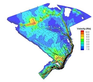
The Sedimentation & River Hydraulics Group develops numerical (computer) models to simulate river hydraulics; sediment erosion, transport, and deposition; water temperature; and riparian vegetation growth and mortality. Some of these models are still in a research stage, but many are available for public download along with a user’s manual. These downloads can be found under TSC's Computer Software page. |
 |
