- Reclamation
- California-Great Basin
- Area Offices
- CCAO
- Field Offices
- New Melones
- Planning Your Visit
Planning Your Visit
UPDATES:
- Reclamation announces seasonal changes at New Melones Lake
- Reclamation reopens Angels Creek Launch at New Melones Lake
- Reclamation announces New Melones Lake summer operating hours and temporary closures
- Tuttletown boat ramp now open!
- Purchase New Melones day-use and annual passes online — CLICK HERE!
- Reclamation announces seasonal closures, hours at New Melones from Oct. 1 through March 31 (News Release)
- Reclamation temporarily bans open burning campfires and charcoal barbeques at New Melones Reservoir (Sept. 2, 2022)
New Melones is part of Reclamation’s Central Valley Project. It is located off of Highway 49, some 8 miles north of Sonora and 6 miles south of Angels Camp, in the Mother Lode.
Each year, around 600,000 visitors enjoy New Melones’ numerous recreational opportunities. Facilities include day use areas; boat launch ramps; more than 300 campsites; hiking, biking and equestrian trails; a visitor center and museum; and abundant water-based recreation.
Reservoir Conditions
Lake conditions vary seasonally at New Melones Lake depending on weather and annual rainfall. Visit the following link for the most up-to-date lake condition information https://cdec.water.ca.gov/dynamicapp/staMeta?station_id=NMS
UPDATE: October 5, 2023
What’s closed?
- Campgrounds: Manzanita, Chamise; and Oak Knoll
- Day Use Areas: Osprey and Black Bart in Glory Hole Recreation Area
- Glory Hole Dump Station, both fish cleaning stations
What’s open?
- The Visitor Center and Museum are open Wednesday through Sunday, 10 a.m. to 4 p.m. (closed Mondays and Tuesdays)
- The Administrative office is open Wednesday through Saturday, 8 a.m. to 4:30 p.m. for pass sales
- Entrance gates to Tuttletown and Glory Hole recreation areas remain open daily from 4 a.m. to 9 p.m.
- Campgrounds: Acorn; Big Oak; Ironhorse (closing on Nov. 1)
- Day Use Areas (within Tuttletown and Glory Hole): Heron Point, Eagle Point, Lupine, and Buck Brush
- Boat Launches: All boat launches remain available in both Tuttletown and Glory Hole
- Trails: All hiking trails including Natural Bridges
- Tuttletown dump station
- New Melones Lake Marina (customers should contact 209-785-3300 for more information)
- Special Use activities including fishing tournaments, equestrian events, houseboat launching, etc. If you have additional questions, contact Park Ranger Eric Johnson at 209-536-9094 ext. 219 or ejohnson@usbr.gov.
Please keep New Melones beautiful by following these minimum impact practices:
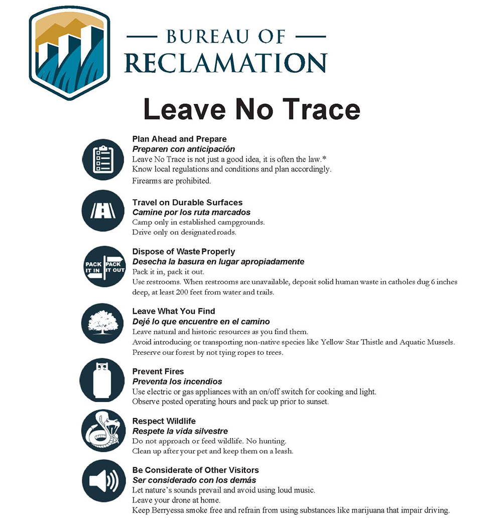
Download PDF Version:
English | Spanish
Location
New Melones Lake is located on Highway 49, approximately 8 miles (13 km) north of Sonora and 6 miles (9 km) south of Angels Camp, California. Located in the Mother Lode, it is within a short drive of other attractions such as Railtown 1897 in Jamestown, Columbia State Park, Calaveras Big Trees State Park, and only a 1.5 hour drive to Yosemite National Park. Interactive Map
The Bureau of Reclamation provides developed facilities at Glory Hole and Tuttletown Recreation Areas. Easy access is found off of Highway 49.
For a detailed map of the New Melones Lake area click HERE (PDF - 2.1MB).
Located in the Sierra Nevada foothills, the weather is typical of California, with a dry, hot summer and wet winter pattern.
Temperatures can reach 113 °F (45 °C) in the summer to a winter low of 14 °F (-10 °C). Annual precipitation varies from 20 inches (50 cm) in the vicinity of the New Melones Dam to 40 inches (101 cm) in the upper reaches of the reservoir. Most precipitation falls between November and April.
| Jan | Feb | Mar | Apr | May | Jun | Jul | Aug | Sep | Oct | Nov | Dec | |
|---|---|---|---|---|---|---|---|---|---|---|---|---|
| Hi | 55 | 58 | 62 | 69 | 80 | 94 | 101 | 98 | 90 | 84 | 78 | 66 |
| Lo | 33 | 36 | 38 | 42 | 47 | 53 | 59 | 57 | 53 | 45 | 38 | 33 |
New Melones Lake is open for year-round use. Some campgrounds are closed in the winter season for resource recovery and the performance of necessary maintenance tasks are the primary reasons for the closures.
For your safety and security, the access roads to the Tuttletown and Glory Hole Recreation Areas are closed at night. Gate times vary by season as shown below:
| Dates | Times |
|---|---|
| April 1 – Memorial Day (May) | close 10 p.m.; open 4 a.m. |
| Memorial Day (May) – Labor Day (September) | close 11 p.m.; open 4 a.m. |
| Labor Day (September) – September 30 | close 10 p.m.; open 4 a.m. |
| October 1 – March 31 | close 9 p.m.; open 4 a.m. |
Your pet is welcome to come along with you during your visit; however, whether in the campground or on a hiking trail, New Melones Lake requires the animal to be on a leash no longer than six feet (1.8 m) in length and pets are not to be left unattended at any time. Please note, pets are not permitted on the Natural Bridges trail.
New Requirement - New Melones Lake staff, to help stop the spread of invasive Quagga and Zebra mussels, will be distributing self-inspection and certification hand-outs to all boaters and watercraft users entering the lake at the Glory Hole and Tuttletown entrance stations. Education, public outreach, and self-certification will continue throughout the season to prevent the spread of these invasive species. The Bureau of Reclamation and multiple Federal, State, and local agencies are urging boaters and watercraft users to help stop the spread of Quagga and Zebra mussels. The greatest threat to further spreading the mussel invasive to lakes, rivers, and other waters is the unintentional introduction by recreational boaters. Transferring a boat from infested water to uninfested water could spread the mussels. For more information, please visit http://www.usbr.gov/mussels/. A self-certification form is available here: Mussel Certification Form
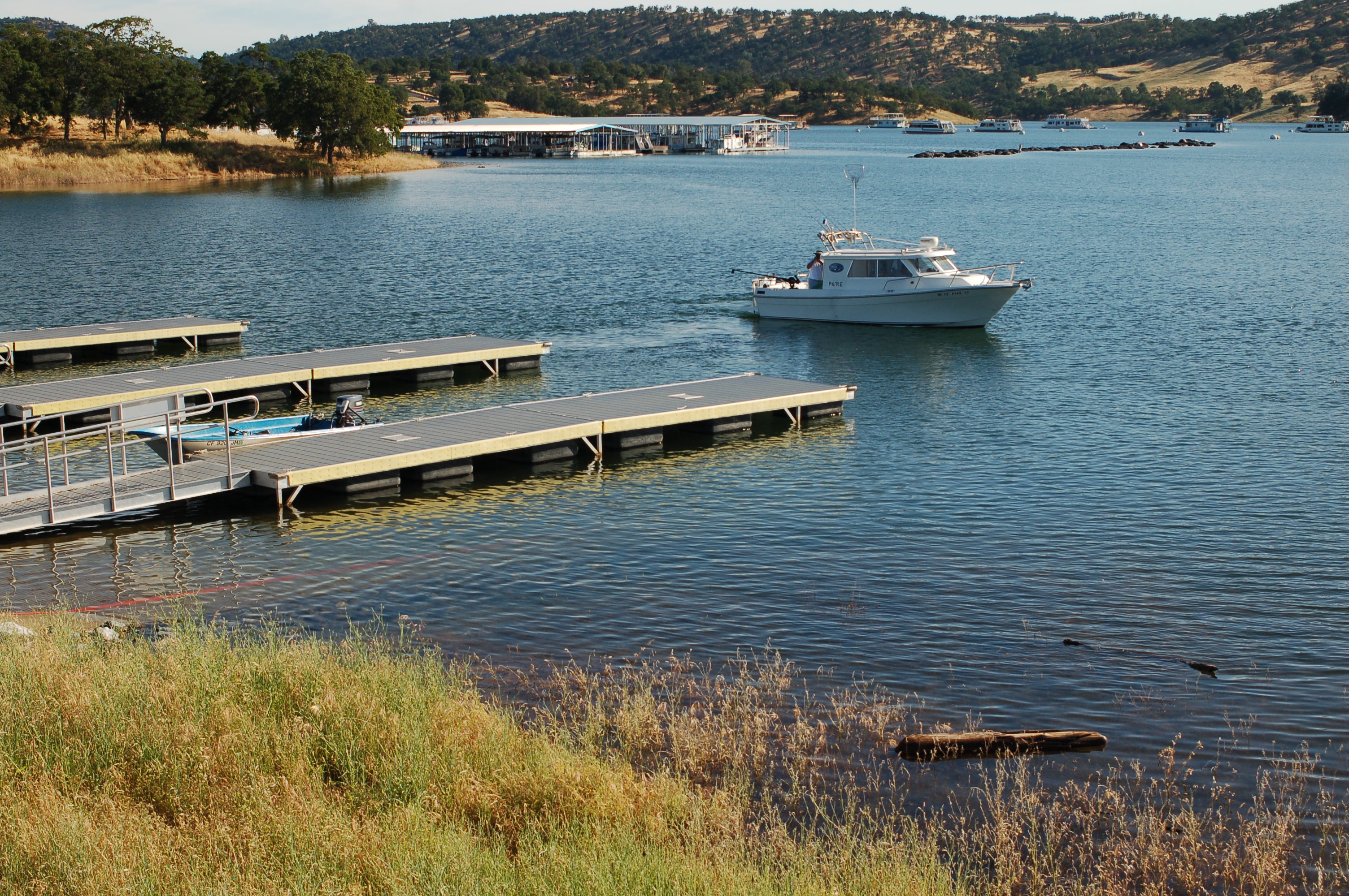 Boat launch ramps with courtesy docks are located in Glory Hole and Tuttletown Recreation Areas. Restrooms, paved parking and launch ramps are provided for your use.
BOATING ADVISORY: Due to the changing levels of the lake throughout the year, boaters should be aware of submerged hazards on New Melones Lake.
The lake is generally fullest in early summer, and lowest in mid-winter. Conditions can change on a daily basis depending on river inflows, and outflows being released through the New Melones powerhouse.
Boaters must have the required safety equipment on board their boat such as lifejackets, ski flag, fire extinguisher etc. as required by the U.S. Coast Guard and California Department of Boating and Waterways. For more information on boating laws and requirements, visit their website.
Day use such as picnicking, shoreline fishing, hiking, and biking is permitted in all recreation and outlying areas around New Melones Lake. Day use parking and picnicking is not permitted in the campgrounds.
Reservations can be made for Eagle Point Group Picnic Area in the Tuttletown Recreation Area. The cost is $60.00 per day, no overnight camping is permitted in the Eagle Point Group Picnic Area. To make a reservation visit www.recreation.gov or call 1-877-444-6777.
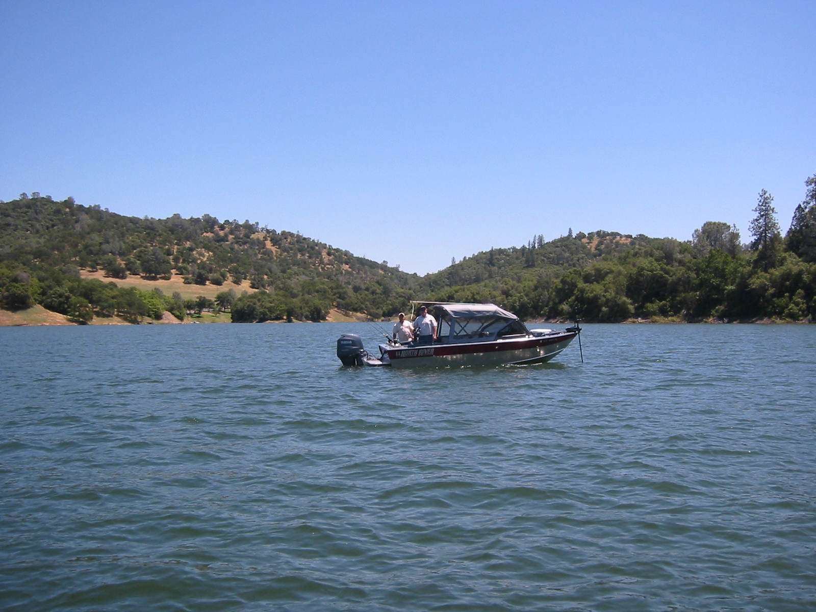 One of the “lures” of New Melones Lake is its superb fishing. Water conditions sustain a variety of game fish to challenge anglers. Throughout the year, a wide variety of special events also provide fun and challenges for anglers of all ages and skill levels.
New Melones Lake holds up to 2.4 million acre-feet of water, provides 12,500 surface acres (5,058 ha) of water for recreational opportunities, and is surrounded by 100 miles (160 km) of shoreline.
For information on the current lake level, visit the website of the California Department of Water Resources.
- Fishing License Information - The California Fish and Game Commission requires that all individuals 16 years of age and older must purchase an annual license before fishing in California. The penalty for fishing without a proper license can be costly, so keep your license up to date, with you, and displayed properly at all times when fishing at New Melones Lake. If you do not have a fishing license, you can purchase one at the New Melones Lake Marina, Glory Hole Sports, Lake View Sports Supplies, Walmart, and other local businesses.
- Daily Fishing Limits - Fishing is open year round at New Melones Lake. Specific daily limits are determined by the California Fish and Game Department and are adjusted annually to insure a sustainable population of each type of game fish. Copies of fishing regulations are available through the California Department of Fish and Game, by calling (916) 227-2245, or via their website.
New Melones Lake has an extensive hiking and biking trail system for visitor use, providing opportunities to explore the area's natural, geologic and cultural resources. There are 20 miles worth of trails in both Glory Hole Recreation Area and Tuttletown Recreation Area. Most of the trails have excellent views of the lake.
Outlying area hiking trails provide visitors with still more challenging opportunities to view some of the unique natural and cultural features of the region including Natural Bridges, the Peoria Wildlife Management Area, Camp Nine, and Table Mountain. Visitors can stop by the Visitor Center and Museum on Highway 49 for detailed maps and trail descriptions.
- Location Map of the trails at New Melones Lake
- Heron Point Map
During your hike or bike ride, we ask you to observe "Leave No Trace" principles. For more information on the Leave No Trace program, visit their website.
Trail Safety
We recommend you observe the following safety tips:
- Never hike alone. Hiking with a partner will allow you to have assistance in case of an emergency.
- Take plenty of water. Stay hydrated - always drink water before you feel thirsty. New Melones Lake is located in a very hot, dry climate and it is very easy to become dehydrated quickly.
- Pace yourself. Due to the climate, the summer temperatures can exceed 100 ºF, and you can be overcome by the heat quickly. Plan your hike for the cooler morning hours whenever possible.
- Be aware of and respect wildlife. New Melones Lake is home to a great deal of wildlife including mountain lions, rattlesnakes, and ticks.
- Mountain lions hunt primarily in the late evening (twilight). Avoid hiking or using game trails, hiking alone or traveling through high grass during twilight and into the night.
- Rattlesnakes prefer the shade during the hot daylight hours, and rock or paved surfaces during the cooler evening hours. Give them the "right of way" and a take a wide path around them. They are not normally aggressive, but will attack if provoked or feel trapped. They can strike from a significant distance.
- Tick bites can be prevented by the use of insect repellents designed to repel ticks or by wearing long pants and long sleeved shirts when hiking. When returning from a hike, check yourself (and your pets) carefully for ticks. Remove ticks carefully and do not leave mouth parts. While it is still uncommon, ticks in this area have been found to carry Lyme disease.
- Pets must be kept on a leash no longer than 6 feet (1.8 m) in length at all times while at New Melones Lake. This is for the protection of your dog as well as for the convenience, safety and courtesy of others.
- Let someone know where you are going and when to expect you back.
- If you are overdue or in need of assistance, have your party contact a New Melones ranger in person or by calling (209) 536-9094, ext. 0 from 8:00 a.m. to 4:30 p.m. After hours, for Glory Hole Recreation Area contact the Calaveras County Sheriff's Dispatcher at (209) 754-6500. For the Tuttletown Recreation Area, contact the Tuolumne County Sheriff's Dispatcher at (209) 533-5815. In case of an emergency, dial 9-1-1.
About the Lake Difficulty Ratings
- Easy - Less than 2 miles (3.2 km) in length with no more than 200 ft (61 m) of elevation change.
- Moderate - More than 2 miles (3.2 km) in length or an elevation change between 200 - 400 ft (61 - 122m).
- Challenging - More than 4 miles (6.4 km) in length or an elevation change of more than 400 ft (122m).
Access
Most parking areas and trailheads are open year round; however, there are seasonal closures between October 1 and March 31.
Tuttletown Recreation Area
(Please Click Here for Tuttletown Map)
- Heron Point: Parking and the trailhead are located at the Heron Point Day Use Area, Tuttletown Recreation Area. This easy, 1.7 mile (2.7 km) trail with views of New Melones Lake ends near campsite 23 in the Acorn Campground. The day use area has picnic tables and flush restrooms, but no drinking water.
- Click here for a map of the Heron Point trail (PDF - 750 KB)
Other and Outlying Recreation Areas
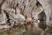 Natural Bridges:
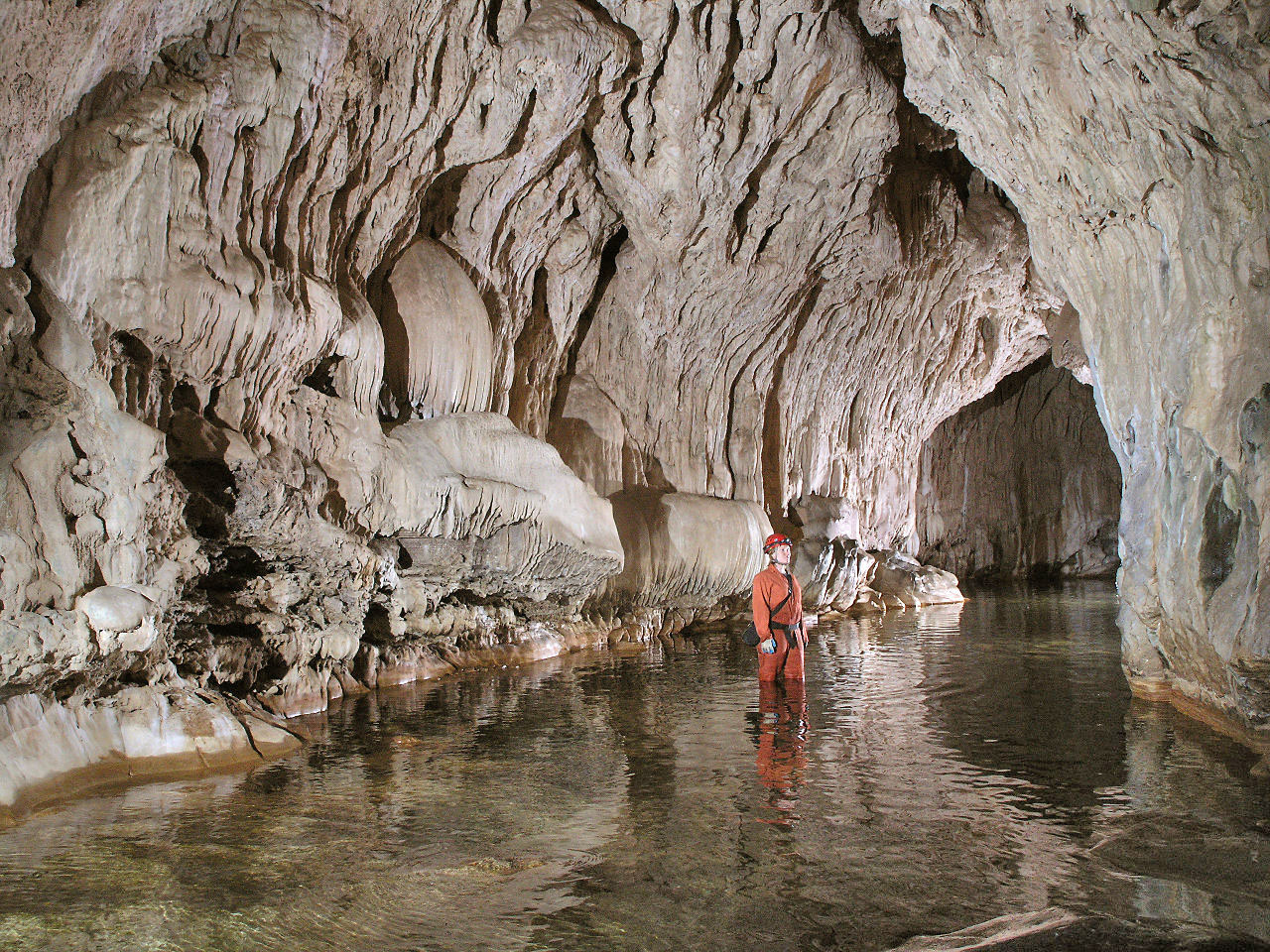
Parking and the trailhead are located on Parrotts Ferry Road approximately 3 miles (4.8 km) north of Columbia. There is limited parking available at the trailhead. There are vault toilets at the parking area, but no drinking water. This moderate, 0.7 mile (1.1 km) trail leads to Natural Bridges, which is a unique series of caves with Coyote Creek running through them. Natural Bridges is an outstanding but sensitive geologic resource at New Melones Lake. Defacing the resources not only spoils the experience for others, but it is against the law. Please help to protect this unique resource by reporting vandalism and preserving the natural features.
Natural Bridges:
Parking and the trailhead are located on Parrotts Ferry Road approximately 3 miles (4.8 km) north of Columbia. There is limited parking available at the trailhead. There are vault toilets at the parking area, but no drinking water. This moderate, 0.7 mile (1.1 km) trail leads to Natural Bridges, which is a unique series of caves with Coyote Creek running through them. Natural Bridges is an outstanding but sensitive geologic resource at New Melones Lake. Defacing the resources not only spoils the experience for others, but it is against the law. Please help to protect this unique resource by reporting vandalism and preserving the natural features. - At New Melones Lake, you may take your pet (on a leash) on most trails; however, in order to protect this unique resource, pets are not permitted on the Natural Bridges trail.
- Natural Bridges trail Map (pdf - 1.03MB)
- Norwegian Gulch: Parking and the trailhead are located at the New Melones Lake Visitor Center and Museum, 1/4 mile (0.4 km) south of the Stevenot Stanislaus River Bridge on Highway 49. The parking lot opens to the public at approximately 8:00 a.m. The Visitor Center and Museum includes picnic tables, flush toilets, and drinking water. This easy, 1/2 mile (0.8 km) trail offers views of New Melones Lake.
- Norwegian Gulch trail Map (pdf - 936KB)
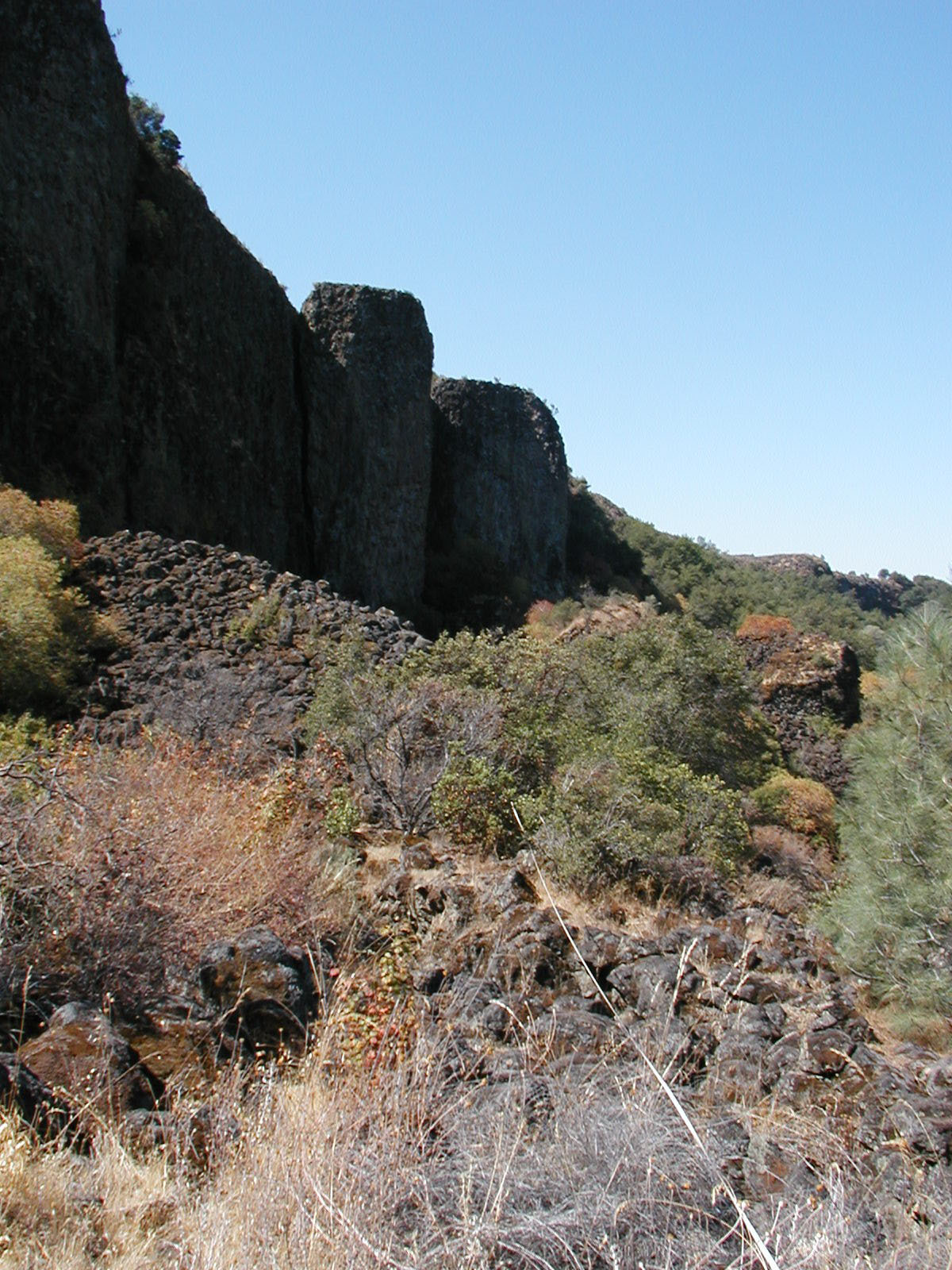
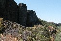 Table Mountain: Parking and the trailhead are located at the end of Shell Road. At the end of the paved (county-maintained) portion, is a gated road for public access that crosses through private property. Please be respectful of the private property owners in using this road. Shell Road is an unimproved dirt road, recommended for high clearance vehicles, and during the winter it may require the use of a four wheel drive vehicle. There are several unlocked gates along this road. Please respect the private property owners by keeping the gates closed. Vault toilets are located near the trailhead, but no drinking water. From the trailhead located past the second unlocked gate, this is a challenging 1/2 mile (0.8 km) trail to the base of Table Mountain that involves some rock scrambling across lava rocks.
- Table Mountain Trail Map (pdf -1.13MB)
Glory Hole Recreation Area
(Please Click Here for Glory Hole Trail Map)
-
Carson Creek: Parking and the upper trailhead are located along the Glory Hole access road (Whittle Ranch Road), approximately 1/4 mile (0.4 km) west of the Glory Hole entrance station. A second access point for the lower trailhead is located at the junction of Angels Creek access road and Whittle Ranch Road. There are portable restrooms at both trailheads. No drinking water is available at the upper trailhead. This moderate, 2.3 mile (3.7 km) trail offers views of New Melones Lake.
-
Frontier: Parking and trailheads are located at the Buck Brush Day Use Area, and at the Carson Creek Trailhead Parking Area. There are restrooms at both trailheads, but no drinking water. This moderate, 2 mile (3.2 km) trail runs parallel to the Angels Creek access road and provides hikers and mountain bikers with a trail connecting Glory Hole's southern trails with its northern trails.
-
Tower Climb: Parking and the trailhead are located along the Glory Hole access road, approximately 1/4 mile (0.4 km) west of the Glory Hole entrance station. There is a portable restroom at the trailhead, but no drinking water. This trail is popular with mountain bikes. It is a challenging trail that is 1.3 miles (2.1 km) in length with several switchbacks and a 400 ft (122 m) elevation change.
-
Gold Rush: Parking and the trailhead are located along the Buck Brush Day Use Area and at the junction of Angels Creek access road and the Whittle Ranch Road. There are restrooms at the trailhead, but no drinking water. This moderate, 2.2 mile (3.5 km) trail ends near campsite 70 in Ironhorse Campground.
-
Angels Creek: Parking and the trailhead are located at the Buck Brush Day Use Area and at the Angels Creek boat launch parking. Picnic tables, flush toilets and drinking water are located at the Angels Creek launch ramp. Flush toilets are also located at the Buck Brush Day Use Area. This moderate, 2.5 mile (4.0 km) trail provides views of New Melones Lake.
- Buck Brush Loop: Parking and the trailhead are located at the Buck Brush Day Use Area. Flush toilets and drinking water are available. This easy, 1.3 mile (2.1 km) trail provides views of New Melones Lake and access to fishing along the shoreline.
Glory Hole Recreation Area Trail Map (pdf - 922KB)
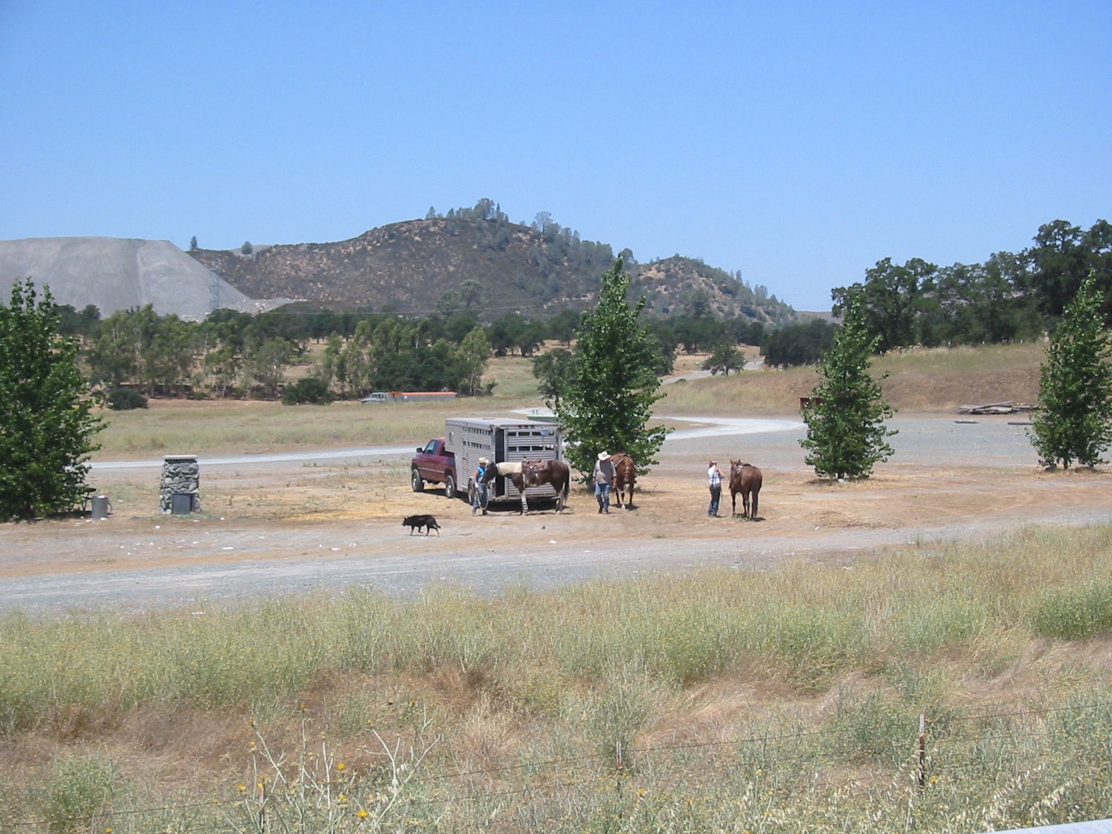 Horseback riding is only permitted in the Peoria Wildlife Management Area (PWMA). The PWMA covers approximately 2,500 acres (1,100 ha) and is located on the southwest side of New Melones Lake.
It was purchased specifically as mitigation for wildlife habitat loss as a result of construction of the New Melones Dam and Reservoir.
- Peoria Wildlife Area map (pdf - 158KB)
Hunting is permitted within designated areas. For a map of New Melones hunting areas, click HERE (pdf - 2.1MB).
Hunters are responsible to know and abide by California Department of Fish and Wildlife regulations found HERE.
For detailed and up-to-date information call
-
(209) 536-9094 Monday through Friday (except federal holidays) between 8 a.m. and 4:30 p.m. or
-
(209) 536-9543 Wednesday through Sunday (except winter federal holidays) between 10 a.m. and 4 p.m.
Note: Documents in Portable Document Format (PDF) require Adobe Acrobat Reader 5.0 or higher to view, download Adobe Acrobat Reader
