

In the early years of irrigation development in Arizona, before the passage of the National Historic Preservation Act in 1966, there were archaeologists, organizations and private citizens who developed information on Arizona's long history of irrigation. An article appearing in the December 1947 "Reclamation Era" describes Arizona's 1500 years of irrigation history.
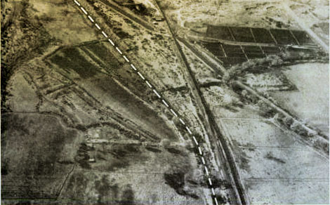 The white dotted line in this aerial photo shows remains of Hohokam hand-constructed diversion ditch for early irrigation. The square-shaped mound below modern irrigation system (upper right) marks Pueblo Grande ruins which hold many secrets of an ancient civilization.
by Odd s. Halseth
City Archaeologist and Director, Pueblo Grande Museum and Laboratory, Phoenix, Ariz
Without agriculture there would be no civilization as we now know it. Man would still be roaming the earth in quest for food, without a chance to settle down to a sedentary form of society and with little or no energy left over for the so-called civilized pursuits of life.
Civilization, or culture of today, is largely a result of man's liberation from spending all his energy in the search for edible plants—and this liberation was brought about by agriculture, or domesticated crop production.
We therefore speak of the "germ of civilization" as wheat in Egypt and Europe, rice in Asia, and—at a much later date—maize, or corn, in the Western Hemisphere.
Much of the early history of agriculture is a matter of written records, except for the Americas, where no phonetic system of writing was in use prior to Columbus. For this reason archaeology plays an important role in unfolding the pre-Columbian chapters of American history.
After the American Indians had learned to cultivate corn and could settle down to sedentary living, they left an accumulation of material remains which have become a great aid to archaeological investigations.
Culture history and chronology are inherent in human refuse deposits, so archaeology must deal with pots and skulls and other material evidence. But it must also deal with the reason for man's behavior and act as the historical detective branch of anthropology, which includes all the branches of the study of man. Archaeology alone cannot solve all the mysteries of human behavior, and often the most careful field work and laboratory studies only produce new problems without solving old ones.
The history of prehistoric farming in Arizona is based on a number of archaeological facts which are coordinated and interpreted according to prevailing evidence and logic, always subject to new information and revision.
The Pueblo Grande Laboratory
This presentation of desert agriculture and irrigation is based on work and studies conducted at Pueblo Grande, a Municipal Prehistoric Monument, established by the City of Phoenix, Ariz., in 1924, and operated as a museum and laboratory of human research since 1929. The interpretation, of course, is that of the writer's.
Corn found its way into Arizona some time about the beginning of our Christian era, and has been grown continuously since that time in both northern and southern parts of the State.
In the northern part, and the adjoining areas of New Mexico, Colorado, and Utah, are found a number of ruins of former Indian farming communities, known as Pueblos. This is plateau country and agriculture is based on dry-farming methods. The present Indians devote most of their ceremonial calendar to prayers for rain, much as their ancestors did centuries ago.
Archaeological study of accumulated culture deposits has helped to establish a continuous chronology for these ruins, from the earliest up to the present time and through the presence of timers with dated tree-rings, accurate dates in our own chronology have been established for many buildings and associated culture material. Where no timber is found to furnish a clue, a relative chronology can be established with fair accuracy through study of such material as trade-ware (pottery, shell, or other objects traded between tribes). This cross-dating is used for ruins found in the desert region, where corn was also grown by irrigation methods.
In the Valley of the Sun (the Salt River Valley) where the city of Phoenix as "arisen from the ashes of the past," like its mythical namesake, and in the nearby Gila Valley, on most of the Pima Indian Reservation, we find evidence of a prehistoric agriculture which was contemporaneous with most of the Pueblo culture on the plateau.
Whereas the Pueblo culture survives to this day, the desert culture seems to have closed its final chapter around 1400 A.D., with what appears to have been a wholesale abandonment of both the Salt River and the Gila Valleys. So far, neither archaeology nor ethnology can prove where the people went or if they have any descendants among any existing Indian tribe.
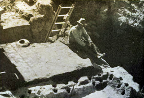 FROM POST HOLES - and other ruins of dwellingsand storage houses - archaeologists find clues to the existence of the Hohokam.
The Pima Indians, who have occupied the same area along the Gila River for about four centuries, speak of the ancients as "Hohokam," a term used to designate the dead, or "those who have vanished." Early investigators report that Pima informers consistently claimed that the ruins of the Hohokam had looked the same "in the memory of all their fathers." However, if one wants to place the Pima in the Hohokam genealogy, it can easily be done with a little wishful thinking.
Whereas the Pima Indians occupied the Gila Valley when first encountered by the Spanish explorers, the Valley of the Sun was not resettled until the arrival of American pioneers in 1867. The reason for this may be found to be a study of hydraulic conditions rather than a matter of cultural archaeology.
History Repeats Itself
A study of an irrigation farming culture must include a study of irrigation technology, and, as engineers remind us, all the laws of nature are not operating on the surface, but underground as well, often in a vital, and even fatal, form.
With all the engineering knowledge now available, farmers in this area are at the present time in desperate need of more water, while several conditions indicate that the prehistoric farmers were greatly troubled by too much of the same commodity. A brief survey of recent irrigation history will help to clarify some points in question.
The Valley of the Sun, also known as the Salt River Valley and the Salado Valley, from the name of its river, was first farmed by whites in 1867. The river was then a deep and narrow stream with a permanent flow, far in excess of needs, particularly during the winter month. but with the expansion of farming activities in the valley and, what is far more important, with the destruction of the watershed by cattle, lumber, and mining industries, things began to happen with an alarming speed. The Salado became an erratic stream. Within a few years it left is narrow bed and cut new ones with increasing force of floods from the watershed.
One flood might leave a new channel a mile from the previous one and farmers were kept so busy repairing intake dams that by the time repairs were made, the flood was over and little or no water was left for irrigation of summer crops.
With the passing of the Reclamation Act in 1902, and the subsequent construction of Roosevelt Dam, storage was provided for the floodwaters and the farmers were happy in the belief that their troubles were over. But they figured without the underground activities of Mother Nature, and it wasn't long before another problem reared its head, or at least came to the surface.
This was a rising water table, a condition brought on by the lack of sufficient underground drainage. An estimated one-fifth of the water used for irrigation goes into the ground. Where the natural equilibrium is as sensitive as it seems to be in this valley, it is only a matter of time and irrigation before the table starts rising and the only method of control is drainage by pumping.
By 1918 one-third of productive land was waterlogged in the Salt River Valley. The water table was within a few feet of the surface of some 80,000 acres, and actually covered the surface in some places. during some years the water table rose as much as 5 feet in places measured, but, with the aid of about two million dollars to purchase and install about 200 deep-well pumps, the farmers were saved again.
After the water table had been lowered to a safe depth, pumping continued for irrigation purposes. This, in turn, helped to create a problem which at the present time concerns desert farmers everywhere. The laws of Mother Nature cannot be settled in the legal courts, it seems, and man is slow in realizing that she will not be violated without penalties.
The Hohokam did not suffer any such manmade destruction of the watershed as the rugged Americans did; but, unless Mother Nature inflicted her vagaries only upon the white man, we must assume that the Hohokam farmers also were subject to having their lands water logged. They spread irrigation water over their lands and sent that fatal one-fifth as an addition to the natural water table for a matter of some 700 years.
The chronology obtained from a large number of undisturbed Hohokam trash mounds reveals an occupation beginning some time before 700 A.D. Many of these trash mounds date from about 1400 A.D. in the top level and go back to the earlier date in the bottom level.
In some trash mounds examined in the Gila valley, the top level ends with material from the 700 A.D. period, thus indicating an abandonment of some villages in the Gila Valley at the time the Salado (or Salt River) valley was first settled.
Origins in the Gila Valley
The beginning of the Gila Valley trash mounds starts several centuries earlier, though no accurate date can be given as yet, but it is obvious that irrigation originated in this valley, perhaps by direct flooding from the river and later by canal construction.
The Gila River, unlike the Salado, runs in a bed which is cut through a series of terraces which, in turn, lie several feet below the upper desert level. During high stages of the river, these bottom lands could easily be inundated and covered with rich silt, thus affording an ideal place for flood irrigation and farming on a small scale. It would be an inviting place for any band of Indians looking for a location to plant whatever domesticated seeds they had.
The areas subject to flood irrigation could not have been very extensive, however. as late as a century ago the Gila was described as a comparatively narrow stream, about 75 feet wide in some places, with bottom lands extending for about one-quarter of a mile in both directions. since both the human and the environmental factors would be closer between Hohokam and Pima history than with our own, it might be well to look at the Hohokam through some of the known Pima experiences.
Before the white intrusion, the Pima Indians lived in about a dozen separate villages, each with its own canal, or ditch. The total population was about 4,000, divided into some 800 to 900 households, each farming an average of 10 acres. They did most of their work with hand tools made from ironwood, mesquite and cottonwood.
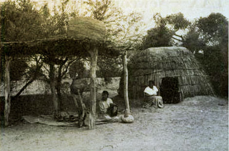 FROM PIMA INDIANS - who were using Hohokam irrigation systems when found by the Spaniards - come legends of the ancients. Photo from Reclamation ERA magazine.
Ditches averaged about 3 miles in length and were dug by the shareholders of each, sometimes within 1 year, depending on the manpower situation. Apache wars, hunting expeditions, saguaro and mescal gatherings and other distractions made some projects last 3 years, or more. The ditches were planned to irrigate the first land about a mile below intakes, which were constructed of "logs, poles, and brush." Except for periodic cleaning, water ran in the ditches "most of the year" and no head gates were used. Water was abundant. Some informants describe the older ditches as about 10 feet wide at the intakes, tapering to from 3 to 5 feet at the terminals. The sides were dug almost straight down with a taper of only about 1 foot, and water usually ran "knee-deep."
With the white man came better tools and implements as well as a demand for farm produce, so after 1860 the Pima Indians expanded their subsistence farming into business production and enjoyed a period of real prosperity.
But not for long. A ruthless civilization was on the march, Mother Nature reacted in her customary manner, and as the water supply gradually diminished, more and more farm land went back to brush and mesquite, and many Indians took up wood cutting and went to work for their neighbors.
After much legal dispute the Coolidge Dam was built and to the detriment of both Pima and archaeology the several floods coming down the Gila, after the destruction of the watershed, washed away much of the bottom land and covered up some areas with many feet of silt. We shall never know how much evidence of early Hohokam occupation has been lot of this change of the valley.
We may safely say, however, that when the time came for the Hohokam to expand their farming to the desert level, their only alternative was to build canals long enough and big enough to carry water to the higher level, which they eventually did.
First "True Irrigation Culture" Along Salt River
This marks the birth of the only "true irrigation culture" in prehistoric North America, and it made it possible for the Hohokam to utilize for the first time the rich lands along the Salado River.
By 700 A.D. a number of settlements were established in the area where Phoenix, Tempe, and Mesa are now located, and during the next 500 years more than 20 villages were occupied, and at least 10 separate canal systems had been constructed.
The construction size of some of these canals was enormous. Some measure over 30 feet from crown to crown and 10 feet in depth. A total of about 125 miles of canal construction has been surveyed in the Salado valley.
How much water they carried is, of course, unknown and it may not even be of great importance to the history of what followed. What counts mostly is the amount actually used for irrigation and that fatal one-fifth which goes into the ground to build up the local water table. As yet, no fair estimate can be made of this amount, either. We have to rely mostly on the time element in considering water logging of Hohokam lands. Although some village areas are known to have covered form 50 to 75 acres, like that of Pueblo Grande, we cannot use this for a population estimate.
Hohokam dwellings were flimsy structures with no lasting quality. The custom of burning a home where death occurred was, and still is, common among desert tribes and probably was practiced by the Hohokam. If so, one single generation would be responsible for the building of several houses in different parts of the village.
Towards the end of the occupation, we find another form of architecture in Hohokam villages and it is here that evidence of water logging shows most strongly at Pueblo Grande. A huge mound-like structure, common to all late village sites, was constructed at Pueblo Grande during the last centuries of Hohokam history. The mound itself covers an area of about 300 by 150 feet and stands to a height of more than 20 feet above the desert level.
Superficially the mound resembles the caved-in ruins of a multi-storied Pueblo type of dwelling, which is the main reason for the early archaeological designation of the Hohokam ruins as Pueblos.
Some archaeologists still refer to these mounds as ruins of multi-stored dwellings, although only one such ruin has been found so far in the Hohokam area. This is the "Big House" at Casa Grande National Monument, which is the only one of its kind and unlike the typical Hohokam mounds, although it was also used as a granary.
Excavations of the Pueblo Grande mound show that it was built up by a series of purpose fills and that on the top of each fill a single-storied structure was erected for storage purposes.
On the bottom levels floors are found with storage pits and storage bins, with evidence of much decayed vegetable material. One room on an upper level produced a large number of storage ollas (earthenware jars), many of which were filled with charred corn. So far there is no evidence of any domestic use of the filled areas, so we may reason that each floor level, of which there are eight, represents a granary structure.
Floor plans vary with each level, showing both masonry and wattle wall construction. No large roof timbers, such as those used in Pueblo construction, are in evidence and roofs appear to have been of typical desert materials and style—the forked post with poles and brush covering. The fills consist of materials from gravel, loam, and old trash mound deposits and were carried in by the basket load. After the first two fills a masonry wall was built around the mound to retain the dirt on each extended platform level. rooms were later built against the outside of this retaining wall and another separate wall enclosed the whole unit, forming a compound not unlike the arrangement of the "blockhouse" built for protection against the Indians on the Plains.
Therefore, we have evidence pointing to the use of these structures for both food storage and protection. Farmers always have gone to greater effort in building safe storage for their crops than in making their own dwellings, and no effort is too great for protection against marauding enemies.
But why the fills? Of the many possible answers, the most logical seems to be water logging. With a rising water table and the capillarity of desert soil, moisture easily could have found its way to the granary floors during late Hohokam times, and every farmer knows what that means. With no facilities for pumping, the Hohokam probably hoped to escape the moisture by elevating their granary floors and kept on filling until they finally decided to leave the valley.
When they left, there must have been some who could not be taken along, or refused to leave for other reasons. this remnant seems to have built their dwellings on the highest available ground and we find their remains on the last level of the abandoned granary mounds.
Within a little more than two centuries the Hohokam compounds and granaries had been built, filled in and rebuilt several times, and finally abandoned. Even the Casa Grande compound and village were abandoned, probably last of all.
About 1500 years of irrigation history have shown that many irrigation problems are common to the past and the present and that it pays to correct past mistakes before making new ones.
In one way our society differs from that of the Indians. With them, responsibility was to the family and tribe only; ours is to the whole world, as well as to the Nation, the State and the community.
(Photographs used with this article were kindly submitted by Mr. Halseth from his personal files)
Source: December 1947 Reclamation ERA magazine.