

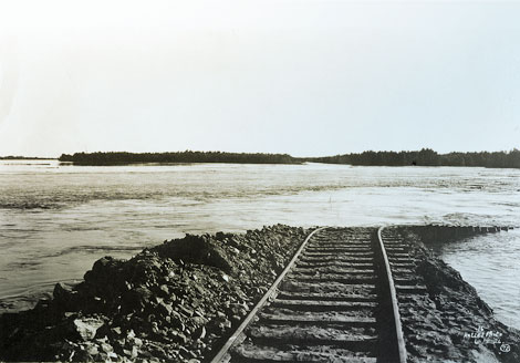
 Flooding of the Imperial Valley in California during 1902-1905, when the Colorado River broke through its embankment, contributed to the decision to build a dam on the river. (Reclamation photograph)
Between 1905 and 1907, the Colorado River flooded several times. It broke through its banks, flowed into an "old channel" and inundated over 100,000 acres of fertile farm land in the Imperial Valley of Southern California. It devastated farmers and farm land alike, and left behind an inland lake known as the Salton Sea. At the end of World War I, the Imperial Irrigation District (in California) sought federal support for construction of a flood control and storage dam in the lower Colorado River Valley, most likely in the Boulder Canyon region. About the same time, the Reclamation Service also began looking at a dam on the lower Colorado River. In 1920, Congress authorized the Reclamation Service to develop preliminary plans for the All-American Canal in California and a storage dam on the Colorado River.
Reclamation Service director Arthur Powell Davis envisioned the new dam providing hydropower as well as irrigation water; the electricity generated by the dam would help pay for its construction. There was much politicking by private business interests that did not want to see the federal government encroach on private energy development. In the end, the Reclamation Service prevailed and began designing the new dam. By 1924, a dam site in Black Canyon, rather than the initial one in Boulder Canyon, was determined to be the preferred choice. The new location provided a larger reservoir pool and would be less costly to construct based on anticipated savings in material and logistical expenses. In spite of the new location in Black Canyon, the project remained the "Boulder Canyon Project."
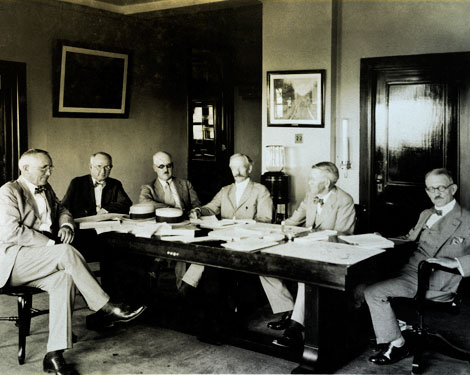 The Colorado River Commission, with Secretary of Commerce Herbert Hoover serving as chairman, met in Santa Fe, New Mexico, in the Fall of 1922. Here, during a sometimes contentious meeting, they hammered out an agreement governing future water rights allocation on the Colorado River. The resulting Colorado River Compact divided the river into an "Upper Basin" comprised of Wyoming, Colorado, Utah, and New Mexico and a "Lower Basin" comprised of Nevada, Arizona, and California that lies downstream from Lee's Ferry near the Utah/Arizona border. (Reclamation photograph)
Before any serious political action could occur on the Boulder Canyon Project, important issues related to water rights had to be addressed by those states that had an interest in Colorado River water. The river's watershed is located in parts of seven states: Wyoming, Colorado, Utah, New Mexico, Arizona, California, and Nevada. The river is one of the most important sources of water in the Southwest, and every state wanted a share of its flow.
Except for water used by farmers in the Imperial Valley (and a few other locales such as the Palo Verde Valley near Blythe), most of the river's flow remained unused and unclaimed in the early 1920s. Under the doctrine of appropriation, rights to this water would accrue to whatever person or organization first diverted it for "beneficial use." As a result of a 1922 U.S. Supreme Court ruling that was focused on a dispute between Colorado and Wyoming over claims to the North Platte River, it became clear to students of Western water law that a strict application of the appropriation doctrine ("first in time, first in right") would apply to competing claims on Colorado river water no matter what state they originated in. With California poised to lay claim to vast quantities of water that would be stored at Boulder Canyon, the other states in the Colorado River watershed became concerned that California would eventually monopolize control over the entire river simply because water could be more quickly, easily, and profitably diverted along the lower reaches of the river.
Acting under the authority of the federally sponsored Colorado River Commission (with Secretary of Commerce Herbert Hoover serving as chairman), representatives from the seven states came together in Santa Fe, New Mexico, in the Fall of 1922. Here, during a sometimes contentious meeting, they hammered out an agreement governing future water rights allocation. The resulting Colorado River Compact divided the river into an "Upper Basin" comprised of Wyoming, Colorado, Utah, and New Mexico and a "Lower Basin" comprised of Nevada, Arizona, and California that lies downstream from Lee Ferry near the Utah/Arizona border. The annual flow of the river (generously estimated at 18 million acre-feet per year with two million reserved for delivery to Mexico) was to be divided equally between the two basins.
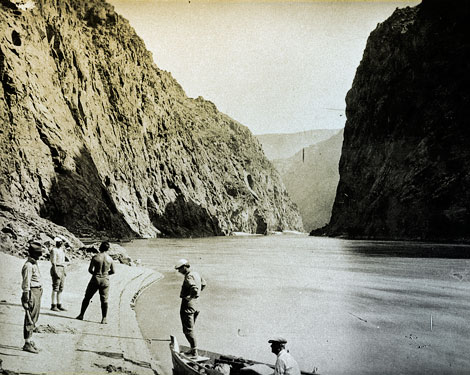 Both Boulder Canyon and Black Canyon (pictured) offered dramatic, narrow gorges with steep walls climbing upwards from the river for hundreds of feet. By 1924, a dam site in Black Canyon was determined to be the preferred choice. The new location provided a larger reservoir pool and would be less costly to construct based on anticipated savings in material and logistical expenses. (Reclamation photograph)
California agreed to limit its consumption to 4.6 million acre-feet per year. The Upper Basin states supported the compact's terms because they would be guaranteed future use of seven and one half million acre-feet per year without fear that California could preempt their claims. In the Lower Basin, Nevada was satisfied because the eventual construction of the dam would foster general economic development in the state's southern region. California was generally pleased because, despite giving up potential rights to unclaimed water in the lower Colorado River, they gained political support from Upper Basin states that would prove invaluable in the battle for congressional approval of the Boulder Dam Project.
Arizona, however, was bitterly opposed to the Compact and refused to ratify it. The state's opposition stemmed from the fact that the Lower Basin, as a whole, and not individual states, was guaranteed rights to half of the river's flow. Because California was better prepared to take advantage of the stored water than was Arizona, it was possible that California could monopolize control of the Lower Basin's allotment with Arizona permanently deprived of use of the river. The legal battle between Arizona and California over water rights came to the forefront with the Colorado River Compact. It remained intense until a U.S. Supreme Court ruling in the early 1960s finally brought it to an end.
The final and official ratification (by all states except Arizona) of the Colorado River Compact did not occur until March 1929. Federal legislation for construction of a storage dam had already been approved by Congress and the President. Neither the Compact nor the dam would have become a reality by themselves. The two were born out of the need for the seven basin states to reach agreement about how to share the water, as well as out of the desires of California political and business interests to gain access to the waters of the Colorado River.
(Taken and adapted from The History of Large Federal Dams: Planning, Design, and Construction by David P. Billington, Donald C. Jackson, and Martin V. Melosi. U.S. Department of the Interior, Bureau of Reclamation, Government Printing Office, Washington D.C. 2005)