- Reclamation
- Missouri Basin and Arkansas-Rio Grande-Texas Gulf
- Recreation
- Wyoming Recreation
Wyoming Area Office (WYAO) Recreation
- Wyoming Area Office Homepage
- Natrona County Parks
- Wyoming State Parks
- Nebraska Game & Parks - Lake Minatare State Recreation Area
- Pathfinder National Wildlife Refuge - US Fish & Wildlife Service
- Wyoming Game and Fish Department
- Recreation.gov - Your gateway to discover America's Great Outdoors!
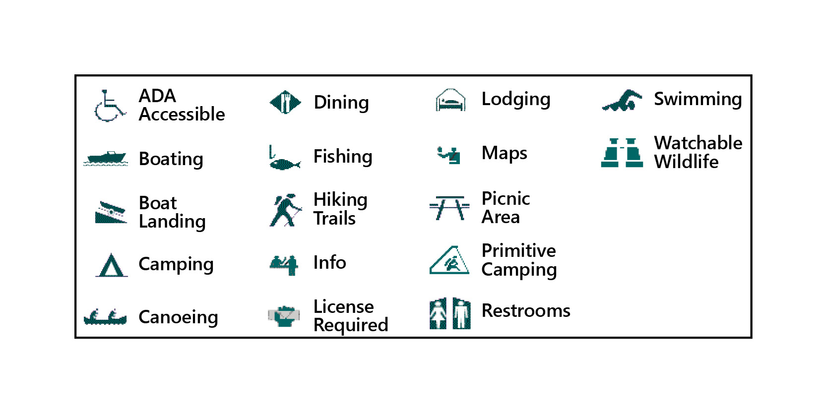
WYAO has recreation opportunities from northwest to southeast Wyoming east of the continental divide and in western Nebraska. Keyhole Reservoir in northeast Wyoming is operated by the Dakotas Area Office. Many of the recreation sites listed below are managed by state or local managing partners. Additional information about the managing partners and the sites they manage is available on their websites:
 "America the Beautiful - National Parks and Federal Recreation Lands Pass" (replaces Golden Eagle, Golden Age, Golden Access and National Parks passports) discounts are NOT ACCEPTED for admission to Reclamation managed facilities or parks – with the exception of the New Melones Lake Reclamation managed recreation areas. This pass can be used for admission to facilities and parks that receive benefits and revenues from the Federal Lands Recreation Enhancement Act, like New Melones Lake; however, other Reclamation facilities do not receive revenues through this Act.
Alcova Reservoir:


Recreation is managed for the Bureau of Reclamation by the Natrona County Roads, Bridges, and Parks Department, 538 S. Wyoming Blvd., Mills, WY 82644; (307) 235-9325. Access from U.S. 220 via County roads 406 or 407. Six campgrounds, 8 boat ramps, interpretive trail, and marina concession. Available species include brown trout, cutthroat trout, rainbow trout, and walleye. Rainbow and brown trout are stocked annually. Dinosaur interpretive trail is located near Cottonwood Creek Beach. A barrier-free fishing pier, restroom, and shelter are located at Black Beach. View information regarding Current Reservoir Data.
Anchor Reservoir:
Managed by the Bureau of Reclamation, Wyoming Area Office, P.O. Box 1630, Mills, WY 82644; (307) 261-5671. Located on the South Fork of Owl Creek 38 miles northwest of Thermopolis, WY via highways 120 and 170. The site is very remote and has a vault toilet and primitive camping.
Boysen Reservoir:

Recreation is managed for Reclamation by Boysen State Park, Boysen Rt., Shoshoni, WY 82649; (307) 876-2796. Located on U.S. 20, 10 miles north of Shoshoni. Fishing open year-round with State fishing license. Fish species include trout, walleye, perch, and ling. Approximately 20,000 surface acres. Good access via shoreline roads and boat ramps. Other activities include watchable wildlife, big game hunting in season with State license, rockhounding, and horseback riding. Annual winter carnival held in February. Available services include developed campsites and RV sites with dump stations, drinking water, tables, wind screens, accessible restrooms, and accessible boat ramps. View specific public facilities for this site. View Current Reservoir Data.
Buffalo Bill Reservoir:
Recreation is managed for Reclamation by Buffalo Bill State Park, 47 Lakeside Rd., Cody, WY 82414; (307) 587-9227. Located 8 miles west of Cody, on U.S. 14-16-20 (Yellowstone Highway). Fishing open year-round. Wyoming State fishing license required. Fish species (coldwater) include rainbow trout, brown trout, lake trout (mackinaw), and cutthroat trout. Good access via shoreline roads and 3 boat ramps. Water surface covers approximately 8,000 acres. Additional blue-ribbon quality fishing available on Shoshone River above and below reservoir. Available services include devel oped accessible campsites and RV sites with dump stations, drinking water, tables, accessible restrooms, wind screens, and primitive campsites. Other activities include watchable wildlife, big game, and waterfowl hunting in season with Wyoming State license. Hiking and horseback riding. Popular windsurfing area. View specific public facilities for this site. View Current Reservoir Data.
Deaver Reservoir:
Recreation is managed by Bureau of Reclamation, Wyoming Area Office, P.O. Box 1630, Mills, WY 82644; (307) 261-5671. Located off Wyoming State 114, 3 miles northwest of Deaver. Popular local warm and cold-water fishery includes trout, walleye, and catfish. Fishery open year-round with Wyoming State fishing license. Approximately 800 surface acres. Boating with motors less than 10 horsepower. Available services include restroom, picnic tables, primitive boat ramp, primitive camping. No drinking water. Other activities include watchable wildlife and waterfowl hunting in season with Wyoming State license. View specific public facilities for this site.
Fremont Canyon Recreation Area:
Managed by the Bureau of Reclamation, Wyoming Area Office, P.O. Box 1630, Mills, WY 82644; (307) 261-5671. Located on the North Platte River 4 miles downriver from Pathfinder Dam. Interpretive signs, barrier-free restroom and picnic shelter are provided. The area is also popular for rock climbing.
Glendo Reservoir:


Glendo State Park, P.O. Box 398, Glendo, WY 82213; (307) 735-4433. Recreation is managed for the Bureau of Reclamation by Wyoming State Parks and Historic Sites. Located on the North Platte River, 6 miles southeast of the town of Glendo, in Platte County. Access from I-25 via County Rd. 17 (Glendo Park Road). Glendo State Park has 7 campgrounds, 6 boat ramps, and a marina concession. Available species include walleye, yellow perch, and channel catfish. Channel catfish are stocked in the reservoir. Brown trout, rainbow trout, and channel catfish are stocked in the river above the reservoir. Below the dam, the river is stocked with brown, rainbow, and cutthroat trout. Plans to stock the river immediately below the dam with largemouth bass and channel catfish. Scenic overlooks and three interpretive nature trails. The Glendo Dam Wetlands Trail, located along the river, just below the dam, features two fishing/observation piers. The Muddy Bay Wetlands Interpretive Nature Trail is located on the east side of Muddy Bay. Glendo Dam Overlook Trail is located north of Glendo Dam. Across from Glando Powerplant below the dam there is a boat ramp giving access to the North Platte River. View specific public facilities for this site. View Current Reservoir Data.
Gray Reef Reservoir:
Recreation is managed for the Bureau of Reclamation by Natrona County Roads, Bridges, and Parks Department, 538 S. Wyoming Blvd., Mills, WY 82644; (307) 235-9325. Located on the North Platte River 30 miles southwest of Casper, in Natrona County. Access from U.S. 220 via County Rd. 412. Under its prescribed function as a reregulating reservoir, the water surface elevation of Gray Reef fluctuates widely from nearly full to nearly empty on a daily basis. Therefore, fish are not stocked in the reservoir. A barrier-free fishing pier and restroom are located at Gray Reef Dam. A primitive campground is located below the dam. Canoes and other small watercraft may be launched from the campground. Available species include brown trout, cutthroat trout, rainbow trout, and walleye. Rainbow and cutthroat are stocked in the river below Gray Reef Dam. A boat ramp and parking lot are located one-half mile downstream of the dam. View specific public facilities for this site. View Current Reservoir Data.
Guernsey Reservoir:
Guernsey State Park, P.O. Box 429, Guernsey, WY 82214; (307) 836-2334. Recreation is managed for the Bureau of Reclamation by Wyoming State Parks and Historic Sites. Located on the North Platte River, 2 miles northwest of the town of Guernsey, in Platte County. Access from I-25 via U.S. 26 and County Rd. 1606. Guernsey State Park has 7 campgrounds and 3 boat ramps. Available species include walleye, yellow perch, and channel catfish. Guernsey Reservoir is severely drawn down twice a year, which affects fish population densities. View specific public facilities for this site. View Current Reservoir Data.
Keyhole Reservoir:
Recreation is managed for Reclamation’s Dakotas Area Office by Wyoming State Parks, 353 McKean Rd., Moorcroft, WY 82721; (307) 756-3596. Eight miles north off I-90 (Exit 165) between Moorcroft and Sundance. Public use area, camping, picnic areas, trailer dump station, concession, swimming, boating, hiking, and fishing. Available species include walleye, bass, and northern pike. Open all seasons. View specific public facilities for this site. View Current Reservoir Data.
Kortes Reservoir/Miracle Mile Area:
Managed by the Bureau of Reclamation, Wyoming Area Office, P.O. Box 1630, Mills, WY 82644; (307) 261-5671. Located on the North Platte River 54 miles southwest of Casper, and 34 miles northeast of Rawlins, and in Carbon County. Access from I-80 via Carbon County Rd. 351. Access from U.S. 220 via Natrona County Hwy. 407 and Carbon County roads 291 and 351. Kortes Reservoir is located in a narrow canyon below Seminoe Dam. No boat ramp available due to frequent water surges from Seminoe Dam. No boat ramp available due to frequent water surges from Seminoe Dam. The Miracle Mile Area extends downstream approximately 5.5 miles from the bottom of Kortes Dam to the boundary of the southern management unit of the Pathfinder National Wildlife Refuge. Eleven primitive camping areas in the Miracle Mile. Available species include brown trout, cutthroat trout, rainbow trout, and walleye. No fish stocked in Kortes Reservoir. Rainbow trout stocked annually in the Miracle Mile. A barrier-free fishing pier and restroom are located at the Mi racle Mile. View specific public facilities for this site. View Current Reservoir Data.
Lake Alice:
North Platte National Wildlife Refuge, (managed from Crescent Lake National Wildlife Refuge), 10630 Rd. 181, Ellsworth, NE 69340; (308) 762-4893. Lake Alice, with a surface area of 752 acres and nearly 6 miles of shoreline, lies almost entirely within the North Platte National Wildlife Refuge. The west side of the reservoir features an undisturbed bird sanctuary. As the reservoir is nearly drained during the non-irrigation season, there is no viable sport fishery in the lake. The east side is open to the public during daylight hours from May 15 to Sept 30. No improvements, services, or facilities.
Lake Cameahwait:

Recreation is managed for Reclamation by Wyoming Game and Fish Department, Lander Regional Office, 260 Buena Vista, Lander, WY 82520; (307) 332-2688. Also known as "Bass Lake". Located off U.S. 26, 15 miles west of Shoshoni. Fishing year-round with Wyoming State license. Fish species include trout, bass, perch, ling, bluegill, green sunfish, and crappie. Good access via shoreline roads. Approximately 80 surface acres. Available services include: picnic/camp shelters, accessible restrooms, boat ramp, and primitive camping. No drinking water. Other activities include swimming, hiking, watchable wildlife, waterfowl, and big game hunting in season with Wyoming State hunting license. View specific public facilities for this site.
Lake Minatare State Recreation Area:
Lake Minatare State Recreation Area, Box 188, Minatare, NE 69356; (308)783-2911. Managed as a State recreation area by the Nebraska Game and Parks Commission. Lake Minatare, with a surface area of 2,158 acres and slightly more than 7 miles of shoreline is a part of the North Platte National Wildlife Refuge. Available species include channel catfish, crappie, small mouth bass, white bass, walleye (15 inch minimum), wipers, and yellow perch. Walleye, channel catfish, and gizzard shad are stocked in the reservoir annually. Motorized boats are permitted. The area is open to the public from Jan. 15 to Sept. 30. View specific public facilities for this site.
Newton Lakes:
Recreation is managed for Reclamation by Wyoming Game and Fish Department, 2820 State 120, Cody, WY 82414; (307) 527-7125. Located 5 miles northwest of Cody, off Wyoming 120. East Newton Lake is a trophy trou t fishery. Open year-round. Wyoming State fishing license required (special regulations apply). Approximately 80 surface acres. Boating with motors less than 10 horsepower. Area popular for float-tubing. Shoreline fishing easily accessible. Available services include picnic tables, accessible restrooms, primitive boat ramp. No drinking water. No overnight camping. Other activities include swimming and watchable wildlife. View specific public facilities for this site.
Ocean Lake:
Recreation is managed for Reclamation by Wyoming Game and Fish Department, Lander Regional Office, 260 Buena Vista, Lander, WY 82520; (307) 332-2688. Located off U.S. 26, 20 miles west of Riverton. Fishing year-round with Wyoming State license. Fish species include trout, walleye, perch, bluegill, green sunfish, and crappie. Limited access via shoreline roads. Several boat ramps located at developed recreation sites around lake. Approximately 6,000 surface acres. Available services include campsites with tables, windscreens and shelters, group picnic shelters, accessible restrooms and shelters, boat ramps, and primitive camping. No drinking water. Other activities include big game and waterfowl hunting in season with Wyoming State hunting license, hiking, watchable wildlife, and horseback riding. View specific public facilities for this site.
Pathfinder Reservoir:
Recreation is managed for the Bureau of Reclamation by the Bureau of Land Management and Natrona County Roads, Bridges, and Parks Department, 538 S. Wyoming Blvd., Mills, WY 82644; (307) 235-9325. Located on the North Platte River 47 miles southwest of Casper, in Carbon and Natrona counties. Access from U.S. 220 via County roads 408 or 410. Parts of the reservoir are included in the Pathfinder National Wildlife Refuge. There are 3 campgrounds and 3 boat ramps. Available species include brown trout, cutthroat trout, rainbow trout, ohrid trout, and walleye. Rainbow and cutthroat trout are stocked annually in the reservoir. The Pathfinder Interpretive Center and 1.7-mile interpretive trail are located near the dam. The interpretive trail may be accressed across the historic suspension bridge or from the dam. View specific public facilities for this site. View Current Reservoir Data.
Pilot Butte Reservoir:
Recreation managed by the Bureau of Reclamation, Wyoming Area Office, P.O. Box 1630, Mills, WY 82644; (307) 261-5671. Located 25 miles west of Riverton, on U.S. 26. Fishing year-round with Wyoming State license. Fish species include trout, ling, and crappie. Limited shoreline access via roads. Approximately 1,000 surface acres. Available services include picnic/camping shelters, accessible restroom, and boat ramp. No drinking water. Other activities include swimming, hiking, and watchable wildlife. View specific public facilities for this site.
Ralston Reservoir:
Recreation is managed for Reclamation by Wyoming Game and Fish Department, 2820 State 120, Cody, WY 82414; (307) 527-7125. Located off U.S. 14A, 15 miles east of Cody. No fishing. Excellent wildlife viewing area, especially wetland and waterfowl species (ducks, pelicans, and sandhill cranes). Available services include accessible bridge and walkway to viewing area. No restroom. No overnight camping. No drinking water. Waterfowl hunting in season with State license. View specific public facilities for this site.
Seminoe Reservoir:
Seminoe State Park, Seminoe Dam Rt., Sinclair, WY 82334; (307) 328-0115. Recreation managed for the Bureau of Reclamation by Wyoming State Parks and Historic Sites. Located on the North Platte River, 72 miles southwest of Casper, and 38 miles north of Sinclair, in Carbon County. Access from I-80 via Carbon County Rd. 351 or from U.S. 220 via Natr ona County Hwy. 407 and Carbon county Roads 291 and 351. Seminoe State Park provides 3 campgrounds and 3 boat ramps. Available species include walleye, brown trout, rainbow trout, and cutthroat trout. The reservoir is stocked annually with rainbow and cutthroat trout. Adjacent to Seminoe Dam, near the north end of the reservoir, the Morgan Creek drainage area comprises approximately 4,752 acres of forested lands within the Seminoe Mountains. Administered by the Wyoming Game and Fish Department as a winter range for elk and bighorn sheep. Open to hunting, but closed to grazing, camping, and fires. View specific public facilities for this site. View Current Reservoir Data.
Winters Creek Lake:

North Platte National Wildlife Refuge (managed from Crescent Lake National Wildlife Refuge), 10630 Rd. 181, Ellsworth, NE 69340; (308) 762-4893. Most of the Winters Creek Lake lies within the North Platte National Wildlife Refuge. The Northeast side features an undisturbed bird sanctuary. The lake has a surface area of 379 acres and approximately 4 miles of shoreline. Available species include bluegill, channel catfish, largemouth bass, walleye (15 inch minimum), and yellow perch. Walleye are stocked in the reservoir annually. Channel catfish stocked when available. Non-powered boats only. Open to the public from Jan. 15 to Sept. 30, during daylight hours.”