Design Service Technologies |
|
The Bureau of Reclamation's Lower Colorado Regional Modeling and Design Center (RM&DC) provides:
- a broad range of water resource modeling and design services to the Lower Colorado Region, Reclamation, and other Federal entities throughout the western United States;
- one-dimensional, two-dimensional, and three-dimensional surface water and groundwater modeling, integrated with state of the art GIS technology; and
- design engineering services with the use of state of the art technologies.
The RM&DC services are provided jointly by the Lower Colorado Region's Engineering Services Office and the Resource Management Office. The Center offers a broad range of surface water and groundwater hydrologic and hydraulic modeling, and design engineering services, including:
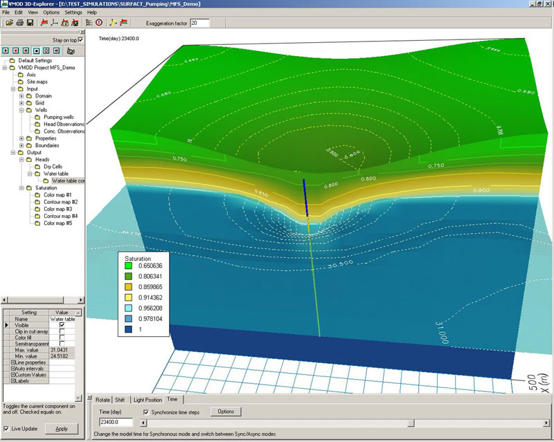 MODFLOW (developed by U.S. Geological Survey) - MODFLOW is a three-dimensional finite-difference groundwater flow model. It has a modular structure that allows it to be easily modified to adapt the code for a particular application. MODFLOW simulates steady and nonsteady flow in an irregularly shaped flow system in which aquifer layers can be confined, unconfined, or a combination of confined and unconfined. Flow from external stresses, such as flow to wells, areal recharge, evapotranspiration, flow to drains, and flow through river beds, can be simulated. MODFLOW (developed by U.S. Geological Survey) - MODFLOW is a three-dimensional finite-difference groundwater flow model. It has a modular structure that allows it to be easily modified to adapt the code for a particular application. MODFLOW simulates steady and nonsteady flow in an irregularly shaped flow system in which aquifer layers can be confined, unconfined, or a combination of confined and unconfined. Flow from external stresses, such as flow to wells, areal recharge, evapotranspiration, flow to drains, and flow through river beds, can be simulated.
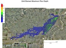 Two dimensional flow analysis is used to predict and map flood hazards including river overbank flooding, unconfined alluvial fan flooding, urban flooding, watershed rainfall/runoff, coastal flooding, tsunamis/storm surges, dam break flooding and mud and debris flows. Two dimensional flow analysis routes a flood hydrograph while predicting floodwave attenuation and reporting on volume conservation. Flood details such as levees, streets, obstructions (buildings), infiltration, floodways, rainfall, sediment transport, and evaporation losses may also be considered in the modeling process. Two dimensional flow analysis is used to predict and map flood hazards including river overbank flooding, unconfined alluvial fan flooding, urban flooding, watershed rainfall/runoff, coastal flooding, tsunamis/storm surges, dam break flooding and mud and debris flows. Two dimensional flow analysis routes a flood hydrograph while predicting floodwave attenuation and reporting on volume conservation. Flood details such as levees, streets, obstructions (buildings), infiltration, floodways, rainfall, sediment transport, and evaporation losses may also be considered in the modeling process.
 HEC-RAS/HEC-GeoRAS (developed by U.S. Army Corps of Engineers (USACE)) - HEC-RAS is designed to perform one-dimensional hydraulic calculations for a full network of natural and constructed channels. HEC-GeoRAS is a set of procedures, tools, and utilities for processing geospatial data in GIS using a Graphic User Interface (GUI). The interface allows for the preparation of geometric data for import into HEC-RAS, and processes simulation results exported from HEC-RAS. HEC-RAS/HEC-GeoRAS (developed by U.S. Army Corps of Engineers (USACE)) - HEC-RAS is designed to perform one-dimensional hydraulic calculations for a full network of natural and constructed channels. HEC-GeoRAS is a set of procedures, tools, and utilities for processing geospatial data in GIS using a Graphic User Interface (GUI). The interface allows for the preparation of geometric data for import into HEC-RAS, and processes simulation results exported from HEC-RAS.
 HEC-HMS/HEC-GeoHMS (developed by USACE) – HEC-HMS is designed to simulate the precipitation/runoff process of dendritic watershed systems. It is designed to be applicable to a wide range of geographic areas for solving a broad range of problems. This includes large river basin water supply and flood hydrology, and small urban or natural watershed runoff. HEC-GeoHMS allows for the integration of GIS with watershed modeling that uses spatial analysis for the development of hydrologic parameters. HEC-GeoHMS also allows the use of radar rainfall and other advanced techniques for modeling a watershed at a grid level. HEC-HMS/HEC-GeoHMS (developed by USACE) – HEC-HMS is designed to simulate the precipitation/runoff process of dendritic watershed systems. It is designed to be applicable to a wide range of geographic areas for solving a broad range of problems. This includes large river basin water supply and flood hydrology, and small urban or natural watershed runoff. HEC-GeoHMS allows for the integration of GIS with watershed modeling that uses spatial analysis for the development of hydrologic parameters. HEC-GeoHMS also allows the use of radar rainfall and other advanced techniques for modeling a watershed at a grid level.
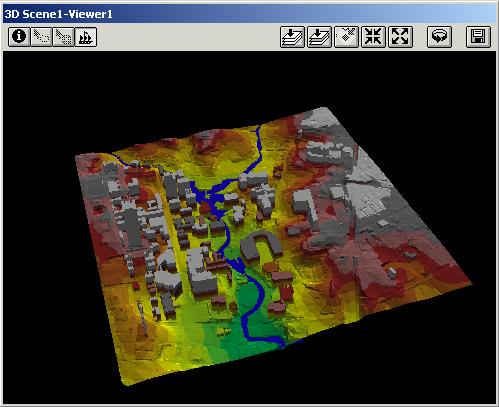
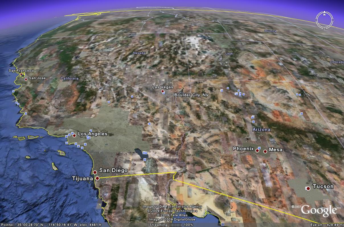 Online Geographic Search Engines allow a user to view satellite imagery, maps, terrain, and 3D buildings, and are increasingly being used by public and private entities as a tool to review historic photographs, superimpose terrain on floodplains to develop 3D flood inundation areas, better understand land use, develop future building layouts in 3D, or simply for aerial reconnaissance. Online Geographic Search Engines allow a user to view satellite imagery, maps, terrain, and 3D buildings, and are increasingly being used by public and private entities as a tool to review historic photographs, superimpose terrain on floodplains to develop 3D flood inundation areas, better understand land use, develop future building layouts in 3D, or simply for aerial reconnaissance.
 Geographic Information System (GIS) - GIS is an integrated collection of GIS software products that provides a standards-based platform for spatial analysis, data management, and mapping. GIS is scalable and can be integrated with other enterprise systems such as work order management, business intelligence, and executive dashboards. GIS is fully integrated with hydraulic and hydrologic modeling such as HEC-GeoHMS and HEC-GeoRAS as developed by the USACE. Geographic Information System (GIS) - GIS is an integrated collection of GIS software products that provides a standards-based platform for spatial analysis, data management, and mapping. GIS is scalable and can be integrated with other enterprise systems such as work order management, business intelligence, and executive dashboards. GIS is fully integrated with hydraulic and hydrologic modeling such as HEC-GeoHMS and HEC-GeoRAS as developed by the USACE.
 Computer Aided Design and Drafting (CADD) helps civil engineers optimize project performance with geospatial analysis to identify the best project site, stormwater analysis for more sustainable designs, quantity takeoff and dynamic earthwork calculations to optimize material usage, and 3D visualizations to better understand project impacts on environment. Computer Aided Design and Drafting (CADD) helps civil engineers optimize project performance with geospatial analysis to identify the best project site, stormwater analysis for more sustainable designs, quantity takeoff and dynamic earthwork calculations to optimize material usage, and 3D visualizations to better understand project impacts on environment.
- RiverWare(tm), a generalized river basin modeling tool, provides a construction kit for developing and running detailed, site-specific models without the need to develop or maintain the supporting software within the water management agency. It includes an extensible library of modeling algorithms, several solvers, and a rich "language" for the expression of operating policy. Its point-and-click graphical interface facilitates model construction and execution, and communication of policies, assumptions and results to others. Applications developed and used by the Tennessee Valley Authority and Reclamation demonstrate that a wide range of operational and planning problems on widely varying basins can be resolved using this tool.
- SAMwin is an integrated system of programs to aid engineers in analyses associated with designing, operating, and maintaining flood control channels and stream restoration projects. SAMwin provides the computational capability to evaluate erosion, entrainment, transportation, and deposition in alluvial streams. Channel stability can be evaluated, and this evaluation can be used to determine the cost of maintaining a constructed project. The three main modules of the package can be used in series, as described, or their separate capabilities utilized to aid in various hydraulic design situations:
SAM.hyd calculates the width, depth, slope and n-values for stable channels in alluvial material, and can calculate riprap size as well as normal depth and composite hydraulic parameters for a cross section with variable roughness.
SAM.sed calculates sediment transport capacity according to a wide range of sediment transport functions, usually using the hydraulic parameters calculated in SAM.hyd.
SAM.yld uses the sediment transport capacity calculated in SAM.sed to calculate the sediment yield.
For more information about the services provided by the RM&DC, contact Doug Blatchford at: dblatchford@usbr.gov, or 702-293-8098.
|

