- Reclamation
- Missouri Basin and Arkansas-Rio Grande-Texas Gulf
- Programs & Activities
- CIP – Project Description
Crow Irrigation Project - Project Description
Overview
Rehabilitation and improvement of the Crow Irrigation Project (CIP) has been separated into five categories ranked in priority as follows:
- Rehabilitation/Betterment of CIP Structures
- Rehabilitation/Betterment of CIP Canals and Laterals
- Alternative On-Farm Irrigation Systems Including Center Pivots, Gated Pipe, Wheel-Lines
- Project Lands/Service Area Crow Tribe Purchase of Non-Tribal Lands
- Developing Irrigation on Future Indian Lands and purchase of Fee land for Future Development – Dunmore Bench
For the efficient utilization of allocated funds, priority will be given first to the rehabilitation and betterment of CIP facilities (structures and canals and laterals), with the remaining funds distributed throughout on-farm improvements and purchase of non-Indian lands. The Dunmore Bench expansion project will be largely dependent on available funds later in the Project. Improving the efficiency and distribution of the current system is the highest priority before new lands are irrigated. These priorities may change as the Project progresses based on input from the Tribe. The total project timeline is 10-15 years.
How Will the Project Be Implemented?
Priorities, priority rankings, and timelines for projects within these five overall categories will be determined using previous analyses, current BIA data, Geographic Information System (GIS) spatial data, aerial photography, and field studies and evaluation. Tribal and public input will also be incorporated into the evaluation and prioritization of projects, including discussions with ditchriders and public meetings with water users.
Typically, priority will be given to projects that affect 1) the highest amounts of tribal or allotted acres; 2) Presently Assessable (PA) lands; and 3) Temporarily Non-Assessable (TNA) lands may also be prioritized in combination with other information. PA lands are acres of land served by one of the irrigation facilities which assess operation and maintenance charges. TNA lands are lands that cannot be cultivated profitably due to a present lack of water supply, proper drainage facilities, or need of additional construction work. Generally speaking, projects at the beginning of a main canal will serve more lands and will be given higher priority. Projects at the end of laterals will serve fewer lands and will be given lower priority.
Coordination with the BIA will occur during all planning, design, and construction activities to determine if any BIA annual canal operation and &M) funding will be used for any tasks to maximize Settlement Act funds.
For each proposed task, the project will start with a thorough field evaluation. After the field evaluation and before construction begins, a Design Option Report will be prepared to summarize the current condition and present the proposed design alternatives for rehabilitation, replacement, or possible removal. If applicable, the design report will include a brief O&M section. Following a decision on the proposed alternative by the Tribe based on input from Reclamation and the BIA, a final design report, plans and specifications, schedule, and cost estimates for the Project will be prepared. Subsequently, after review and approval by Reclamation and confirmation that all approvals are final (e.g., cultural and NEPA), construction activities will commence.
Priority 1 – Rehabilitation and Betterment of CIP Structures
There are several thousand individual irrigation structures that have been identified as in need of repair in the current Engineering Master Plan. Current problems caused by failing structures include: water erosion; soil slumping; structures stuck, leaking, not functioning; concrete deterioration; erosion of adjacent streambanks; equipment that is user-unfriendly, difficult/dangerous to adjust; exposed rebar; and canal prism erosion. The ultimate goal of repairing these existing structures is to allow each particular irrigation unit to operate to the fullest of its capability while minimizing water waste and associated sediment load, risk of system failure, and hazard to human or animal life.
The proposed options to address these problems include: 1) rehabilitation and betterment, 2) total replacement, 3) removal, or 4) abandonment/no action. Creating new structures is also an option where necessary removal or abandonment of existing structures poses a need for an entirely different infrastructure component.
The following list includes those structures within the scope of work of the CIP Master Plan. Click on each type of structure to learn more about what it is, what it does, and what anticipated construction options are proposed for the project: Drops and Checks, Cross, Flumes, Headworks/Diversion dams, Spillway, Inverted Siphon, Wasteway, Chutes, and Turnouts. Infrastructure components that do not fall within the scope of work include the following: Baskets, Bridges, Drain inlets, Measuring devices, Miscellaneous structures, Pipes, Railroad crossings, Underdrains, and Waterboxes.
In addition to the existing structures listed above, the need for new types of structures has also been identified in the CIP Master Plan. The installation of automated structures, such as motorized gates and water measurement devices, would allow more efficient monitoring and operation of the CIP system. Also, fish protection/passage structures may be considered for the project. These structures would be installed based on funding in later implementation stages of the project.
Part of the rehabilitation and repair of CIP structures will include general construction activities that are necessary to complete the work, but may not be directly a part of removing, replacing, or rehabilitating each structure. Click on each type of activity to understand what is involved: Diversion during Construction; Removal of Water from Excavations; Clearing, Stripping, and Grubbing of Vegetation; Earthwork; Riprap Placement; and Seeding and Soil Supplements.
Priority 2 – Rehabilitation and Betterment of CIP Canals and Laterals
A significant portion of the main canal and lateral canal system in the CIP requires substantial rehabilitation due to a lack of maintenance (Tables 1 and 2). The poor condition of a significant portion of the CIP’s infrastructure (e.g., drop structures) has also contributed to excessive erosion along certain reaches of canals. Across the CIP, the vast majority of canals and laterals are unlined earthen canals. Several disadvantages of unlined earthen canals include the potential for water loss due to seepage, potential side slope stability/erosion issues, sedimentation issues, and the need for frequent maintenance to control vegetation growth. Many of the flow restrictions within the CIP are the result of a lack of canal cleaning, with vegetation growth and siltation contributing to significant reductions in the flow capacities of canals in some locations within the CIP. Excessive vegetation growth can also contribute to additional water losses via deep percolation. A major ditch cleaning and reshaping effort needs to be implemented across the CIP.
| Irrigation Unit | Design Capacity (cfs) |
Canal Length for Cleaning and Reshaping (ft) | Total Length of Main Canal (mi) |
| Bighorn | 670 | 167,477 | 31.7 |
| Soap Creek | 50 | 48,365 | 9.2 |
| Agency | 210 | 52,122 | 9.9 |
| Reno | 85 | 43,897 | 8.3 |
| Lodge Grass #1 | 200 | 67,171 | 12.7 |
| Lodge Grass #2 | 37 | 23,812 | 4.5 |
| Wyola | 115 | 45,902 | 8.7 |
| Pryor | 20 | 83,277 | 15.8 |
| Two Leggins | 400 | 34,408 | 6.5 |
| Forty Mile | 30 | 21,789 | 4.1 |
| Bozeman Trail | 70 | 57,366 | 10.9 |
| Unit | Lateral (ft) | Sublaterals (ft) | Drain (ft) | Total (ft) |
| Bighorn | 341,293 | 388,878 | 110,267 | 840,439 |
| Agency | 102,788 | 104,780 | 46,969 | 254,537 |
| Forty Mile | 18,761 | 0 | 3,864 | 22,625 |
| Lodge Grass #1 | 83,069 | 32,894 | 15,987 | 131,950 |
| Lodge Grass #2 | 1,352 | 1,248 | 6,121 | 8,721 |
| Pryor | 32,882 | 3,684 | 0 | 36,566 |
| Reno | 49,533 | 47,809 | 21,937 | 119,279 |
| Soap Creek | 15,265 | 9,225 | 0 | 24,490 |
| Wyola | 29,167 | 3,463 | 23,469 | 56,100 |
| Total | 674,110 | 591,982 | 211,374 | 1,494,707 |
Remediation efforts for canals include several options and needs. Click on each type of activity to learn more about what is involved: cleaning and reshaping, seepage area lining and repair, livestock damage repair, point bar removal, piping of select canal reaches, and repair/maintenance of associated access roads.
The primary focus for the first phase of canal rehabilitation and betterment will concentrate on the main canals across all units. The main canal is the most critical for water conveyance to the rest of the unit’s laterals, sublaterals, etc. The first main year of canal rehabilitation (2015) will be for canal repair damage caused by livestock. The next two years of rehabilitation (2016 and 2017) will be dedicated to those canal areas prioritized as critical and serious. The following years will be for repair of canals ranked as needing minor repairs.
Priority 3 – Alternative On-Farm Irrigation Systems
Flood irrigation methods are the most common irrigation methods currently being utilized across the extent of the CIP. An opportunity exists to improve water efficiency and overall productivity throughout the CIP through the implementation of more efficient irrigation methods. Conversion to more efficient irrigation methods could result in a reduction in water storage shortages and/or canal capacities as well as reduction in potential field runoff and the associated sediment load.
Key on-farm improvement alternatives include, but are not limited to, land leveling, conversion to gated pipe as well as surge irrigation for gated pipe applications, the lining of on-farm ditches, installation of center pivots, and the installation of wheel lines. Click on each alternative to learn more. Additional best management methods such as border dikes, blocked-end-borders, and level basin irrigation are recommended, but are methods farmers could implement themselves with proper educational resources.
On-farm improvement work is proposed to commence in 2018. This is deemed necessary, since adequate and dependable conveyance of water to fields is required prior to the implementation of significant on-farm improvements, particularly in cases involving significant capital investments. Purchase of non-tribal lands (Fee land) would potentially consolidate blocks of tribal lands, which would directly effect on-farm system improvement location and implementation selections.
Priority 4 – Crow Tribe Purchase of Presently Assessable (PA) Fee Lands
There are currently 16,309 acres of PA Fee land in the 9 BIA owned units according to current BIA data. A breakdown of Fee land by unit can be found in Table 3. The Wyola Unit does not contain any PA Fee land.
| Unit | PA Fee Acres |
| Pryor | 246 |
| Bighorn | 10,639 |
| Soap Creek | 546 |
| Agency | 1,629 |
| Reno | 1,277 |
| Lodge Grass #1 | 1,292 |
| Lodge Grass #2 | 414 |
| Wyola | 0 |
| Forty Mile | 265 |
| Total | 16,309 |
Land purchasing will involve numerous factors to determine beneficial tracts of land for consolidation into Tribal service areas. Some of these factors include:
- Tribal input on potential lands they would like to acquire.
- Willing sellers at or near the established market value cost.
- The number of sides a parcel is bordered by Tribal and/or Allotted land to create larger, continuous parcels allowing for easier irrigation development and potential implementation of on-farm improvements.
- The amount of PA acres in the parcel. Purchasing larger parcels of PA land will increase the feasibility of implementing of on-farm improvements.
- Potential for land in TNA status to be brought back into PA status with minimal improvements.
- Multiple willing sellers in bordering parcels.
Land purchasing will be set to commence in 2015 to allow 3 years of land purchasing before starting on-farm improvements. It is anticipated that land purchasing will assist the implementation of additional on-farm improvements. Land purchasing will occur over a 5 year period.
Priority 5 – Developing Irrigation on Future Tribal and Allotted Lands
Once the current system is rehabilitated, the focus can shift to bringing new lands into the CIP. Close to 18,000 acres of land has been determined feasible for future irrigation development (NRCE 2000). Of this total, approximately 7,000 acres, referred to as the Dunmore Bench, have been identified as a focus for potential irrigation development. Within the Dunmore Bench area, 4,480 acres of land were estimated as Fee lands for purchase and 2,640 acres were identified as land in Trust. These lands are located between the Bighorn and Little Bighorn River, see Figure 1 below.
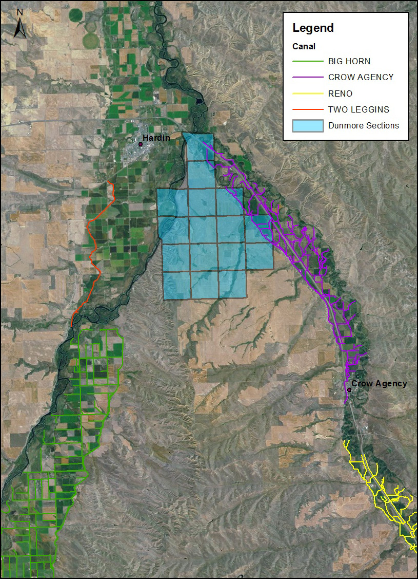
Figure 1: Location of Dunmore Bench Sections of Land
Thorough economic and financial analysis would be performed to determine if the Dunmore Bench is a cost effective investment. The next most important factor is a reliable water source. The proposed water source for the Dunmore Bench is the Bighorn River utilizing the Tribe’s water rights from Bighorn Lake or the natural flow right from the Bighorn River.
Other factors vital to potential development of the Dunmore Bench or other potential lands include: 1) soil classification, as the land must be suitable for crop production with sufficient drainage for successful irrigation performance, 2) land must be in Tribal or Allotted status, 3) lands closer to a water source requiring fewer pumps and piping, 4) contiguous parcels of lands, 5) feasibility of gravity systems utilizing minimum pumping stations/pipelines, 6) willing sellers at or near current market price, 7) availability/proximity of existing canal and electrical infrastructure.
In general, for implementing irrigation development on Tribal and Allotted lands, the overall procedure will first involve the acquisition/identification of acreages for irrigation development. Following an identification of viable acreages, design of the irrigation system will be completed, and the system will thereafter be constructed.
