NEW MEXICO
Dona Ana and Sierra Counties
ELEPHANT BUTTE IRRIGATION DISTRICT
Along Rio Grande River between Caballo Dam, New Mexico and El Paso, Texas
National Register 8/08/1997
The Elephant Butte Irrigation District includes 217 contributing features
spread over a vast discontinuous area. The features are all associated
with the Bureau of Reclamation's Rio Grande Project located along the
Rio Grande River of south-central New Mexico and westernmost Texas. Authorized
in 1905, the Rio Grande Project accomplished the consolidation and reconstruction
of small privately-built water diversion and conveyance structures located
in the Rincon and Mesilla Valleys. For the first time, the supply
of irrigation water became both predictable and dependable; as a consequence,
the amount of irrigated farmland in the Rincon and Mesilla Valleys tripled
to more than 100,000 acres. The principal engineering features of the
Rio Grande Project include Elephant Butte and Caballo storage dams, six
diversion dams (Percha, Percha Arroyo, Leasburg, American, Mesilla, and
Riverside), 141 miles of canals, 462 miles of laterals, 457 miles of
drains, and one hydroelectric plant.
The Elephant Butte Irrigation District listed in the National Register is one of three irrigation systems served by the complex Rio Grande Project. The District contains three of the project diversion dams (Percha, Leasburg, and Mesilla) and over 200 canals, laterals, and drains. Other contributing features include the Leasburg Dam Tender's Residence and four siphons.
In 1996, ownership of a majority of the Elephant Butte Irrigation District was transferred from the Bureau of Reclamation to the Elephant Butte Irrigation District operating entity. Reclamation retains ownership of four contributing features: Leasburg Diversion Dam, Leasburg Dam Tender's Residence, Mesilla Diversion Dam, and Percha Diversion Dam. The latter is also individually listed in the National Register.
Elephant Butte Dam
Eddy County
CARLSBAD IRRIGATION DISTRICT
Vicinity of Carlsbad
National Historic Landmark 7/19/1964
The Carlsbad Irrigation District, also known as the Carlsbad Project,
is a large and complex irrigation project that provides water to about
25,000 acres of farmland in the Carlsbad area and along the valley to
the south. Private entrepreneurs initiated the project in the late
19th century. They touted grandiose plans but were unsuccessful
in seeing them to fruition. In 1905, the Bureau of Reclamation purchased
the struggling project and brought it to completion. The Federally-constructed
features are representative of the early technical innovation and experimentation
of the Bureau of Reclamation. Historically, water was distributed through
a system that included Avalon Dam, McMillan Dam, two primary canals and
a substantial network of laterals. Operation of the project was significantly
modified with the construction of Alamogordo Dam in 1938 and Brantley
Dam in 1988.
In June 2000, title of the distribution system was transferred to the Carlsbad Irrigation District. Of the 29 contributing properties identified in the National Historic Landmark, Reclamation retains title to 18 of them. These include McMillan Dam and Reservoir; McMillan Spillway No. 1; McMillan Spillway No. 2; McMillan West Embankment; McMillan East Embankment; McMillan Railroad Dike; McMillan Gate Keeper's House; McMillan Garage/Boathouse; Avalon Dam and Reservoir; Avalon Spillway No. 1; Avalon Spillway No. 2; Avalon Spillway No. 3; Avalon Suspension Bridge; Avalon Water Distribution System; Avalon Gate Keeper's House; Avalon Garage; Avalon Warehouse; and Avalon Guard House.
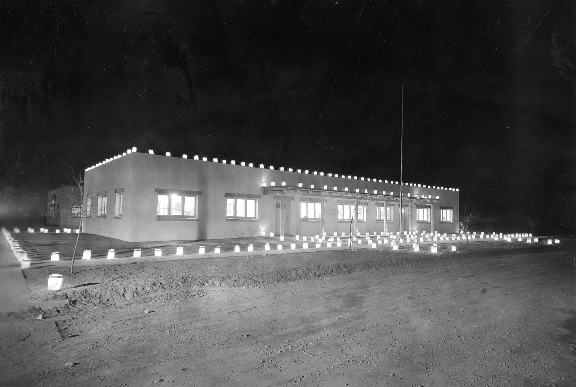
Arch Hurley Building, Headquarters for the Tucumcari Project, in 1940 or 1941
Quay County
ARCH HURLEY CONSERVANCY DISTRICT OFFICE BUILDING
101 E. High St. , Tucumcari
National Register 12/16/1994
The Arch Hurley Conservancy District Office Building was constructed in 1940 by the Bureau of Reclamation as the administrative offices for the Tucumcari Project. Authorized in 1938, the Tucumcari Project provides water to about 34,000 acres of land in east-central New Mexico. Arch Hurley, a local businessman for whom the building was named, played a central role lobbying for the project's construction. Hurley was also the first president of the irrigation district that bears his moniker. The style of the office building is Spanish-Pueblo Revival but in a fairly austere form reflecting the building's origins at the end of the Great Depression. The rectangular plan, one-story building is of concrete block with exterior walls finished with cement stucco. The Bureau of Reclamation and the Arch Hurley Conservancy District both occupied the building from 1940 through 1953. Thereafter, it was used exclusively by the Conservancy District.
Sierra County
PREHISTORIC ADAPTATIONS ALONG
THE RIO GRANDE DRAINAGE, SIERRA COUNTY , NEW MEXICO THEMATIC RESOURCE
NOMINATION
Truth or Consequences vicinity
National Register 12/16/1989
The Reclamation-owned Monticello Point Archaeological district and 15
individual archaeological sites (of which Reclamation owns ten) together
comprise the Prehistoric Adaptations along the Rio Grande Drainage, Sierra
County, New Mexico, Thematic Resources Nomination. The sites represent
prehistoric occupation in the Mogollon culture area in Southern New Mexico
from between circa A.D. 200 to A.D. 1250. Included in the nomination
are sites representing the Mimbres Mogollon culture that occurred west
of the Rio Grande and the Jornada Mogollon culture that occurred east
of the Rio Grande. Some multi-component sites include materials
typical of both cultures. All of the sites are habitation features that
exhibit a wide range of architecture and artifacts.
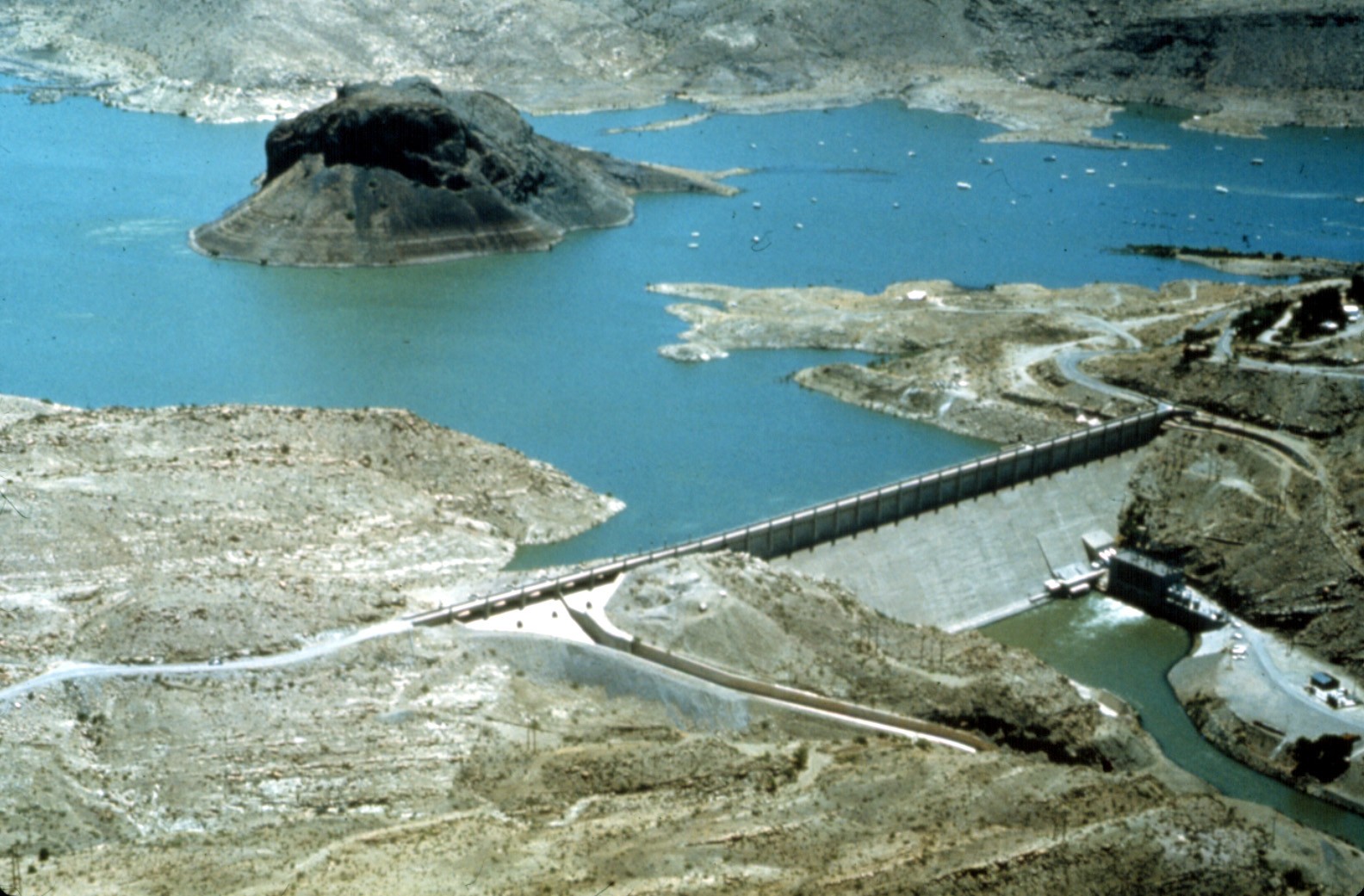
ELEPHANT BUTTE DAM AND RESERVOIR
On the Rio Grande River north of Truth or Consequences
National Register 4/09/1979
Elephant Butte Dam is the principal feature of the Rio Grande Project,
one of the early irrigation projects undertaken by the Bureau of Reclamation
following passage of the Reclamation Act of 1902. Construction of the
project facilities resulted in the delivery of a predictable and dependable
water supply to farmers in the Rio Grande Valley in south-central New
Mexico and west Texas. Built between 1911 and 1916, Elephant Butte Dam
is a gravity concrete structure with a height of 301 feet and a crest
length of 1,674 feet. The enormous dam was a major engineering
feat in its day. It created Elephant Butte Reservoir, the largest
irrigation reservoir in the world when completed. Elephant Butte
Dam is also significant for touching off an historic debate over interstate
and international aspects of water use. Under a 1906 treaty, the
United States is required to provide Rio Grande water to Mexico. Elephant
Butte Dam is incorporated in the Elephant Butte Historic District National
Register listing.
ELEPHANT BUTTE HISTORIC DISTRICT
Roughly along NM 51 from the Elephant Butte Dam to Mescal Canyon and along
NM 52
from Ash Canyon to Long Ridge
National Register 2/10/97
The Elephant Butte Historic District encompasses Elephant Butte Dam and
surrounding historic buildings, structures, and archaeological sites dating
as early as 1908. All are directly related to the construction and
subsequent operation of the dam and reservoir, the principal features
of the Bureau of Reclamation's Rio Grande Project. Many surviving
buildings and structures date to the New Deal and include Civilian Conservation Corps (CCC) - built tourist
facilities and fish hatchery buildings, extensive CCC-built landscaping,
and a Public Works Administration - built hydroelectric plant. There are 74 contributing
features in the district. Although the unifying thread of the district
is its historical importance, elements are also significant for their
architectural and engineering values or for their ability to contribute
important information through archaeological study.
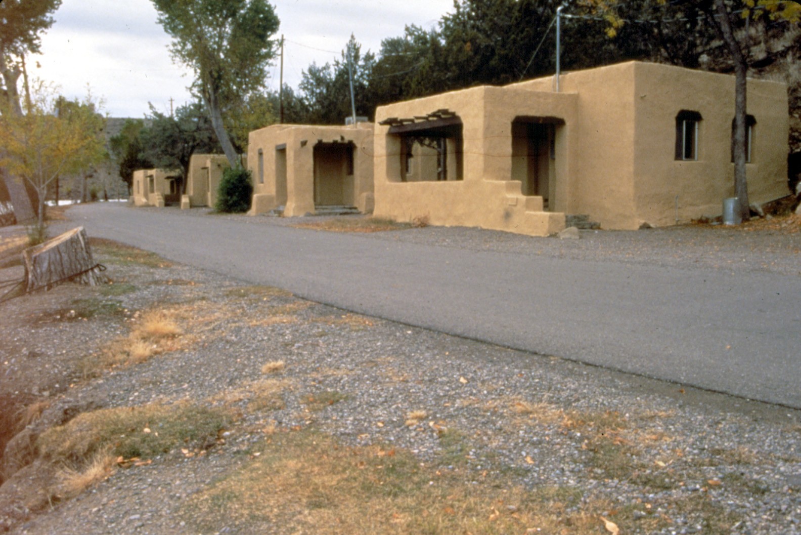
Elephant Butte Cottages
FORT MCRAE
Vicinity of Elephant Butte
National Register 4/07/2005
Fort McRae, a frontier military post in operation from April 3, 1863 , until October 30, 1876, served an important function during that period of Indian and Euro-American conflict in the New Mexico Territory. One of the primary purposes of the fort was to protect nearby Euro-American settlements from Apache depredation. Additionally, the fort was located close to the Ojo del Muerto, one of the only water sources available to travelers along the dreaded Jornada de Muerto, the centuries-old north-south route across the inhospitable desert of central New Mexico, which lay just a few miles east. Today Fort McRae consists of archaeological remains which normally are inundated by the waters of Elephant Butte Reservoir.
PERCHA DIVERSION DAM
2 miles northeast of Arrey
National Register 4/06/1979
Percha Diversion Dam is an integral feature of the widespread Rio Grande
Project, an early Bureau of Reclamation irrigation project that was authorized
in 1905. Construction of the project facilities resulted in the delivery
of a predictable and dependable water supply to farmers in the Rio Grande
Valley in south-central New Mexico and west Texas. Located two
miles downstream from Caballo Dam on the Rio Grande River, Percha Dam
is a concrete ogee weir structure with embankment wings. It was
constructed between 1916 and 1918. The dam diverts water into the Rincon
Valley Main Canal, which provides water to over 16,000 acres of land
in the Rincon Valley. Individually listed in the National Register,
Percha Dam is also included as a contributing feature of the Elephant
Butte Irrigation District National Register District.

Return to National Register Properties Map
