NEVADA
Churchill County
CARSON RIVER DIVERSION DAM
Fallon vicinity across Carson River
National Register 3/25/1981
Part of Newlands Reclamation Thematic
Resources nomination
The Carson River Diversion Dam is an original feature of the Newlands
Project, one of the first five projects authorized and built under the
Reclamation Act of 1902. With passage of the act, the Federal government
assumed a major role in designing and constructing large-scale irrigation
projects throughout the West. The Carson River Diversion Dam is
part of the network of water storage, diversion, and conveyance structures
that provides water for irrigating about 73,000 acres of farmland in an
area that receives less than 4.5 inches of annual precipitation.
Built in 1904-05, the Carson River Diversion Dam is a low concrete dam
that diverts water from the Carson River into two main project canals,
the Southside Main Canal ("V" Line) and the Northside Main Canal ("T"
Line). The Carson River Diversion Dam was individually listed as
part of a thematic resource nomination for the Newlands Project.
GRIMES POINT ARCHAEOLOGICAL
SITE
Fallon vicinity
National Register 2/23/1972
Grimes Point is one of the largest and most accessible petroglyph (rock
art) sites in the United States. There are hundreds of boulders in this
locality with petroglyphs inscribed in them. Designs include circles,
wavy lines, human figures, snakes, and other animal figures. The rock
art is believed to be about 6,000 years old. Visitors can view examples
of petroglyphs along a short, self-guided interpretive trail. The
site is managed by the Bureau of Land Management.
LAHONTAN DAM AND POWER STATION
Southwest of Fallon on the Carson River
National Register 3/25/1981
Part of Newlands Reclamation Thematic Resources nomination, Lahontan Dam
was constructed between 1911 and 1915 as part of the Newlands Project,
one of the first five projects authorized and built under the Reclamation
Act of 1902. With passage of the act, the Federal government assumed a
major role in designing and constructing large-scale irrigation projects
throughout the West. Lahontan Dam is part of the network of water
storage, diversion, and conveyance structures that provides water for
irrigating about 73,000 acres of farmland in an area that receives less
than 4.5 inches of annual precipitation. Following several years
of water shortages after initial project construction, Lahontan Dam was
constructed on the lower end of the Carson River as a storage facility
to ensure farmers a more secure water supply. The 120-foot-high
earthen embankment dam features a unique pair of curved concrete spillways,
one at each end of the dam. Due to the remote location of the dam
site, a hydroelectric power plant was built in association with the dam
to provide power for construction activities.
Clark County
BOULDER CITY HISTORIC DISTRICT
District roughly bounded by Nevada Highway,
Avenue L, Date, and 5th Streets.
National Register 8/19/1983
The Boulder City Historic District is significant for its historic association
with the construction of Hoover Dam. The town was created by the
Bureau of Reclamation to house over 4,000 construction workers in the
harsh Nevada desert. Built at the outset of the Great Depression,
Boulder City was conceived by the Federal government as a model town,
and was designed by Denver city planner and landscape architect S.R. DeBoer. Within the boundaries of the town, a collection of historic resources
conveys a strong sense of the setting, design, and historic association
of the town during its development from 1931 to 1945. The city became
incorporated in 1960 when the Bureau of Reclamation deeded the area to
self-government. A number of contributing buildings are still owned
by the Bureau of Reclamation.
GOLD STRIKE CANYON/SUGARLOAF MOUNTAIN TRADITIONAL CULTURAL PROPERTY (TCP)
Boulder City, Nevada, vicinity
National Register 9/4/2004
The TCP consists of approximately 676 acres of land encompassing two sites, Gold Strike Canyon and Sugarloaf Mountain, that have been significant to the traditional cultural beliefs of the Mojave, Southern Paiute, and Hualapai (and most likely other tribes) for thousands of years. The site is on land administered by the Bureau of Reclamation and the National Park Service.
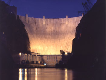
HOOVER DAM
East of Las Vegas outside Boulder City
on U.S. 93
National Register 4/08/1981
National Historic Landmark 8/20/1985
Hoover Dam is among the most recognized and renowned structures built by the Bureau of Reclamation. The dam was authorized for construction in 1928 for purposes of flood control, improved navigation, storage and delivery of the Colorado River's waters, and electrical power generation. Construction of the 726-foot-high concrete dam began in 1933, and it was dedicated September 30, 1935. Upon completion, it was the highest dam in the world and is still recognized as an engineering marvel. Electricity generated and water stored at the dam fueled the economic development of the Southwestern United States, including the rapid growth of Los Angeles. Lake Mead, the reservoir behind Hoover Dam, is the largest man-made reservoir in the United States. In 2013, the National Register and National Historic Landmark listing for Hoover Dam was expanded to become a historic district encompassing properties associated with the dam and its industrial landscape and site tourism. As of 2014, properties in the historic district include the switchyard, a railroad and two roads associated with dam construction, the final mile of the two highway approaches to the dam, a WWII pillbox (defensive gun emplacement), and visitor facilities including Monument Plaza, the original exhibit building, parking areas, elevator towers, restrooms, ticket booths, and a nurse’s station and a guides station. Additional properties are under consideration for inclusion in the historic district.
PUEBLO GRANDE DE NEVADA
Overton vicinity
National Register 10/08/1982
This site attracted widespread attention among archaeologists when it
was discovered in 1924 because it consists of remains of a Pueblo II complex.
It was the farthest west settlement associated with the Anasazi
culture that had been found. Before the site's discovery, it was
a common belief that there were no pueblo remains worthy of attention
west of the Colorado River. This site consists of 46 small multi-roomed
masonry pueblos that were probably the remains of a single community.
Pershing County
RYE PATCH ARCHAEOLOGICAL DISTRICT
Lovelock vicinity
National Register 8/02/1978
The Rye Patch Archaeological District consists of seven archaeological
sites along the edge of Rye Patch Reservoir. The seven sites, which are
classified as either semi-permanent camps or temporary task-related camps,
preserve information about human settlement in the lower Humboldt River
Valley for at least the past 4,500 years.
Storey County
DERBY DIVERSION DAM
On the Truckee River 19 miles east of Sparks
National Register individual listing 4/26/1978
Incorporated in the Newlands Reclamation
Thematic Resources Nomination 3/25/1981.
The Derby Diversion Dam holds the distinction of being assigned the first
design specification issued by the Bureau of Reclamation. The dam is among
the original features of the Newlands Project, one of the first five projects
authorized and built under the Reclamation Act of 1902. With passage
of the act, the Federal government assumed a major role in designing and
constructing large-scale irrigation projects throughout the West.
Derby Diversion Dam is part of the network of water storage, diversion,
and conveyance structures that provides water for irrigating about 73,000
acres of farmland in an area that receives less than 4.5 inches of annual
precipitation. Completed in 1905, Derby Diversion Dam consists of a gated
concrete structure spanning the Truckee River and an earthen embankment
extending from the north abutment for nearly 1,200 feet.
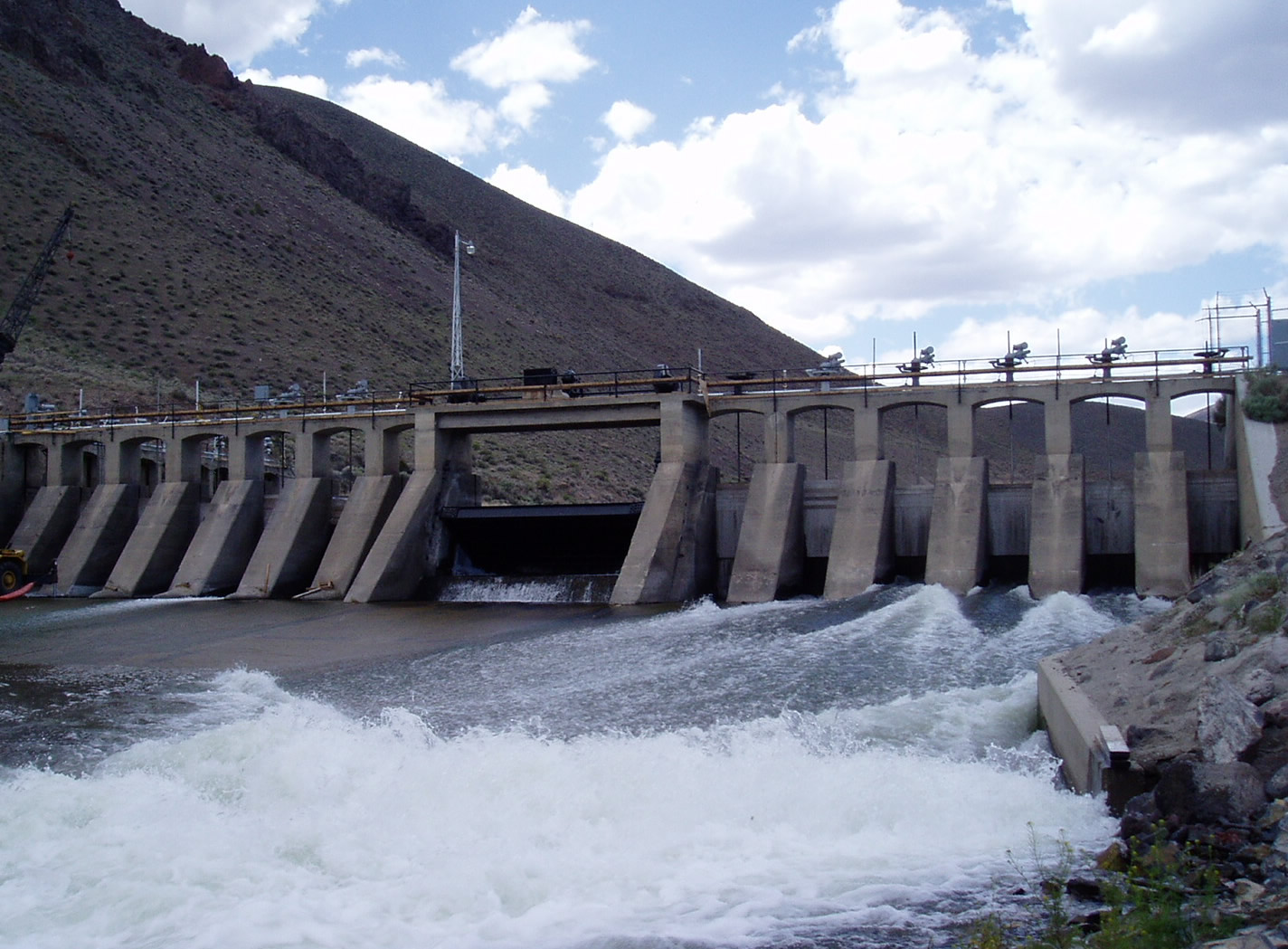
Derby Diversion Dam

Return to National Register Properties Map
