IDAHO
Ada County
BOISE DIVERSION DAM, POWER PLANT, AND DEER FLAT EMBANKMENTS
East of Boise on the Boise River, and southwest of Nampa
National Register 3/15/1976
The Boise Diversion Dam, Power Plant, and Deer Flat Embankments are all features of the Bureau of Reclamation's Boise Project, which provides irrigation water to about 300,000 acres of productive agricultural lands in southwestern Idaho. Completed in 1908, the Boise Diversion Dam is a rubble concrete and masonry weir-type dam. The power plant was added to the diversion dam in 1912. It is one of the oldest Federal power plants in the western United States. The Boise Diversion Dam diverts water into the New York Canal, one of the principal Project canals. The New York Canal carries water to Lake Lowell. The Deer Flat Embankments are two earthfill low embankment dams that create Lake Lowell, near Nampa, Idaho.
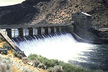
Boise Diversion Dam and Power Plant
Northwest of Pocatello on the south bank of the Snake River
National Historic Landmark 1/20/1961
Boise County
ARROWROCK DAM
About 20 miles east of Boise on the Boise River
National Register 11/09/1972
Arrowrock Dam is a key feature of the Bureau of Reclamation's Boise Project. Arrowrock Dam was constructed between 1911 and 1915, and was the first storage dam for the irrigation project. In addition to supplying water to project land, it also provided supplemental water to farms served by privately-developed irrigation companies that previously lacked sufficient water to reliably serve all of their land. The concrete arch dam was the highest in the world when completed, and retained that title until Reclamation completed Owyhee Dam in 1932.
Minidoka County
MINIDOKA DAM AND POWER PLANT
On the Snake River southeast of Rupert
National Register 10/29/1974
Minidoka Dam and Power Plant are key features of the Minidoka Project. Authorized in 1904, the project was the first Bureau of Reclamation endeavor in Idaho. Construction of Minidoka Dam began in 1904 and was completed in 1906. Lake Walcott, the reservoir created behind the dam, stores water for irrigating arid lands along the Snake River in eastern Idaho. The Minidoka Power Plant, completed in 1909, was the first Federal hydroelectric power plant in the Pacific Northwest. It provides power needed for pumping water to fields on the south side of the Snake River. Excess power was used to electrify local towns and farmsteads, and the benefits of this usage was cited as an example in support of the Rural Electrification Act of 1936. The Minidoka Project was instrumental in transforming the landscape of the area from desert into prosperous farm land. Minidoka Dam HAER PDF (13MB).
Power County
ONEIDA MILLING AND ELEVATOR COMPANY GRAIN ELEVATOR
Offshore in American
Falls Reservoir, American Falls vicinity
National Register 7/16/1993
The Oneida Milling and Elevator Company grain elevator is located in the American Falls Reservoir, which covers the original townsite of American Falls. Built in 1912, the 106 foot high concrete grain elevator remains as the only visible marker of the townsite. In 1925, the community and most of its structures were moved when the reservoir was filled behind American Falls Dam. The Bureau of Reclamation built the dam and reservoir, features of the Minidoka Project, to provide irrigation water to lands in south-central Idaho. The grain elevator is historically significant because of its association with grain production in the area. The use of reinforced concrete, which was a new technology at the time, lends further significance to the feature.
Power County
AMERICAN FALLS ARCHAEOLOGICAL DISTRICT
Downriver
of American Falls
National Register 7/1/1999
The American Falls Archaeological District is located in a canyon along the Snake River downstream from the town of American Falls. The sites in this district represent the span of human occupation in southern Idaho from 12,000 to 14,000 years before present up to the Euro-American era. There are over 150 contributing sites that range from small prehistoric lithic scatters to larger features such as historic structures, representing homesteading or mining-related activities.
Power County
AMERICAN FALLS RESERVOIR FLOODED TOWNSITE
Submerged
in American Falls Reservoir, north of present-day American Falls
National Register 1/28/2002
The submerged remains of the original town of American Falls, Idaho, are located in the reservoir behind American Falls Dam. This town was an established community when the increasing need for agricultural water supplies prompted the Bureau of Reclamation to move portions of the town to higher ground in the mid-1920s in order to flood the lower elevations for water storage. Some of the original features that remain under water have been damaged due to erosion. However, features such as sidewalks, roads and building foundations can be observed during periods of low water. The construction of American Falls Dam played an integral role in Idaho's agricultural history.

Return to National Register Properties Map
Last Updated: 4/30/19
