- Reclamation
- Upper Colorado Basin
- Provo Area Office
- Scofield Dam and Reservoir Lands
- Summary Judgment - 2005, US District Court
- Findings of Fact - 2007, US District Court
- Judgment of Remand - March 2009, US Court of Appeals, Tenth Circuit
- Amended Judgment - June 2009, US District Court
Overview
The Bureau of Reclamation’s Scofield Project came about to replace various private dams built in the early 1900’s by local water user organizations, and which later failed. The current Scofield Dam and Reservoir replaced the original Scofield Dam and Reservoir built by the Price River Water Conservation District in 1925-1926, which partially failed in May 1928.
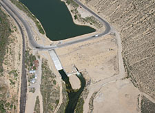
Scofield Dam and Reservoir are located on the Price River in Carbon County, Utah, 85 miles south of Salt Lake City. Scofield Dam was authorized by the president in 1943 to provide irrigation and municipal and industrial water, as well as flood control and recreation benefits to Carbon County. Construction of the dam took place between 1943 and 1946.
Prior to the dam’s construction, the Price Water Conservation District acquired lands in the reservoir basin to ensure the ability to impound water over these lands. Once the project was authorized, the district conveyed these lands to Reclamation. In addition, Reclamation acquired other parcels of land in 1944 from private land owners to accommodate the reservoir. Some of the former owners of these lands retained a “right to use” some Reclamation land below a certain surveyed elevation, in ways “not inconsistent with the storage and flowage of water.”
There is some confusion about the identification of the surveyed elevation which serves as the upper boundary for portions of Reclamation’s land ownership. Surveys completed in the 1920’s, identified the control elevation as being 7630 feet above sea level. While the location of the survey line has not changed, over the years, improvements in surveying have increased the accuracy with which the established line is measured above sea level. Accordingly, the U.S. Geological Survey has corrected how far above sea level the survey line happens to be, but the location of the line on the land has not changed. The survey line is now referred to as elevation 7638.9.
A complex situation currently exists with respect to ownership and right to use the land around Scofield Reservoir. Several historical factors led to the current discrepancy between local residents and Reclamation. First, there are conflicting deeds in county records after the recorded deeds which conveyed title to the Scofield lands to Reclamation. Second, lands were sold or conveyed to private owners based on insufficient title history information. Third, after-acquired-title for a significant land parcel passed to the U.S. in 1944, and the former land owner later gave quit-claim deeds to others which conflicted with the U.S. title.
In 1998, Reclamation filed a quiet title action in federal district court in response to the construction of a home on its land southwest of the dam. Ultimately, the Tenth Circuit Court ruled on behalf of Reclamation, affirming that Reclamation owned the land in fee and ruling that there was not a right to use on the property. The District Court subsequently issued an amended judgment affirming the Tenth Circuit ruling.
Today, there are also two subdivisions and a number of temporary and permanent structures including homes, cabins, house trailers, modular homes, sheds, boat docks, and boat ramps have been built on lands within the flood surcharge pool on lands to which Reclamation holds title.
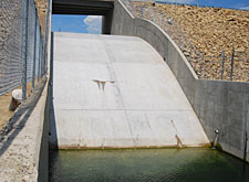
Reclamation’s primary concern about clarifying title to the land, and about the structures that have been built on this land, is the ability to operate the reservoir under flood conditions to ensure the safety and structural integrity of the dam. A rare flood event could compromise the dam’s spillway causing the dam to overflow and potentially causing failure of the dam if debris from structures entered the spillway. This failure scenario would seriously jeopardize the downstream communities of Helper and Price, Utah.
Reclamation conducted a public meeting was held on September 3, 2009, at the Carbon County Events Center to share information, hear concerns, and solicit local representatives to serve on a cooperative committee to continue discussions and help identify potential alternatives to resolve the situation.
For more information, please contact:
Lands Group Chief
Provo Area Office, Bureau of Reclamation
302 East 1860 South
Provo, Utah 84606-7317
(801) 379-1000
