- Reclamation
- Columbia-Pacific Northwest Region
- AgriMet
- General Information
In 1983, in cooperation with the Bonneville Power Administration (BPA), the Bureau of Reclamation (Reclamation) began "piggy-backing" a network of automatic agricultural weather stations onto Reclamation's regional Hydromet satellite telemetry network. The Hydromet network is a series of automated data collection platforms that provide information necessary for near-real-time management of Reclamation's water operations in the Pacific Northwest. As a subset of the overall Hydromet network, this agricultural network, dedicated to crop water use modeling and other agricultural applications, has been identified as AgriMet.
The present AgriMet network consists of over 300 agricultural weather stations located throughout the Western United States (see map). Approximately 166 stations are owned by USBR, while the remaining are cooperative stations with other climate networks. Over 30 stations east of the Continental Divide in Montana are managed by the Burea of Reclamation Missouri Basin Region.
The network is sponsored by the US Bureau of Reclamation with additional support from the Oregon Water Resources Department, Oregon State University, the US Army Corps of Engineers, land grant universities, the Cooperative Extension System, electric utilities, power companies, and other public and private agencies and organizations.
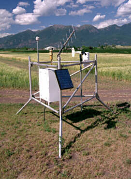
Real-time AgriMet data is transmitted from individual stations (photo) to Reclamation's receive site in Boise, Idaho. Each station's data is collected once an hour. Data collection intervals within the hourly collection period are dependent on the specific sensor equipment at each station. Types of data collected at each station varies. The data is processed on computers at the Boise Regional Office, and then made publicly available.
Data is reviewed daily for quality control purposes, but all numbers should be considered provisional unless officially released by appropriate Reclamation personnel.
