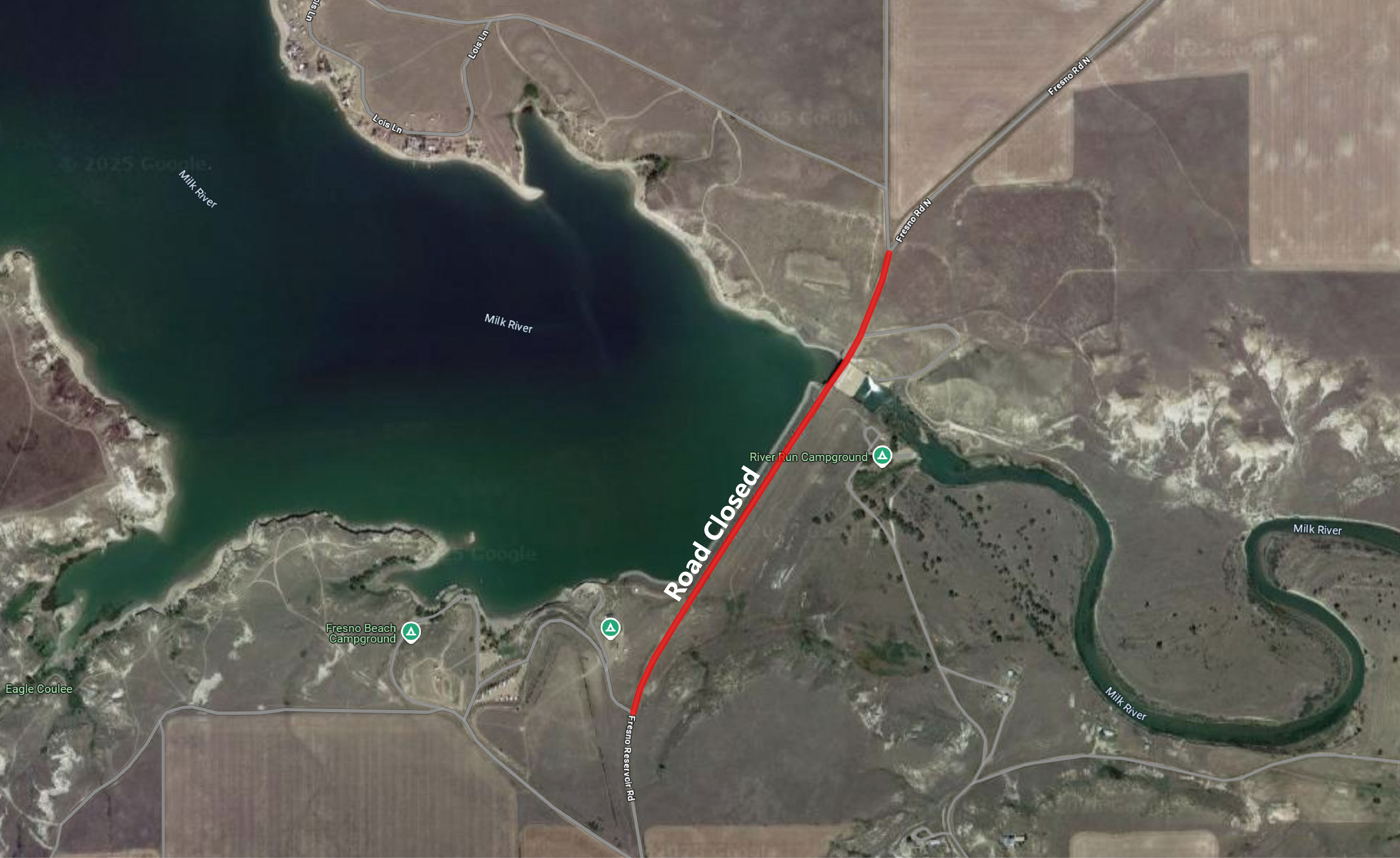
 Map illustrating the temporary road closure at Fresno Reservoir
HAVRE, Mont. – The Bureau of Reclamation will close access to all traffic across Fresno Dam on Fresno Reservoir Road, Wednesday, June 25, through Wednesday, July 2. The temporary road closure is necessary to facilitate work being done by Reclamation’s contractor, NW Construction Inc., related to the Fresno Safety of Dams Modification Project. Travelers are advised to use alternate routes north and south of the dam during the closure.
Fresno Dam was completed in 1939 and is located on the Milk River about 15 miles west of Havre, Montana. The dam is owned and operated by Reclamation.
Fresno Dam has experienced 7-10 feet of settlement, since it was constructed in the 1930’s, increasing the risk of embankment cracking and internal erosion due to differential settlement. These risks exceed Reclamation’s Public Protection Guidelines and require modification of the dam.
For more information about the road closure, contact Ryan Colloton at (406) 247-7306.
Facts about Fresno Dam:
Fresno Dam, located on the Milk River 15 miles west of Havre, Montana, is a compacted earth fill dam with a structural height of 110 feet and a crest length of 2,070 feet. It contains 2,105,000 cubic yards of material. An overflow-type spillway at the north end of the dam provides for a flow of 51,360 cubic feet per second through the concrete-lined channel. The outlet works discharge a maximum of 2,180 cubic feet per second through two 72-inch steel pipe outlet tubes. A conservation storage of 127,200 acre-feet is impounded in Fresno Reservoir. Provision also is made for flood control benefits.
Fresno Dam is located in a valley, which the Milk River has cut in sandstone and shales of the Judith River formation (Upper Cretaceous). The strata of the Judith River formation dip gently east-word and are frequently of the lenticular nature. Foundation is river silts and gravel in riverbed, irregularly cemented, leaky Fresno sandstone in right abutment; sandstone underlain by impervious and fairly stable Sprague shale in left abutment.
Fresno Reservoir provides recreation enthusiasts with opportunities such as boating, camping, fishing, picnicking, water skiing, hunting and wildlife viewing. Reclamation administers public recreation on the federal lands surrounding the reservoir. Privately owned cabins on federal land are administered under lease agreements issued by Reclamation. Montana Fish, Wildlife & Parks manages the fishery in the reservoir, a wildlife management area at the west end, and a public access area on the Milk River immediately downstream of the dam.
With 7,388 surface acres, the reservoir offers fishing for walleye, northern pike, perch and trout. Fresno is one of Montana’s best warm water fishing locations. Rainbow trout were once stocked in the reservoir. However, during the late 1940s northern pike were found and trout populations declined. Northern pike continue to do well in Fresno. Walleye were introduced in the late 1950’s and Fresno has become a popular fishing area for walleye.
Reclamation owned lands surrounding Fresno provide hunting opportunities for waterfowl, antelope, whitetail deer, mule deer, upland game birds, and occasionally moose and elk.
The diversity of land surrounding Fresno Reservoir provides habitat for many wildlife species. Most of the land is leased out for grazing. However, the Fresno Wildlife Management Area includes approximately 2,700 acres on the upper end of the reservoir and is administered by Montana Fish, Wildlife & Parks. This area provides suitable viewing of whitetail deer, mule deer, antelope, waterfowl and upland game birds.
Fresno Reservoir Recreation Facilities:
The reservoir, with 65 miles of shoreline, extends upstream of the dam for approximately 25 miles. Reclamation maintains six recreational areas around the reservoir.
Kremlin Bay Campground: Designated campsites, restroom facilities, day use area, and a concrete boat ramp are located 3.5 miles east and 4 miles north of Kremlin. No trash services are available; Pack -it-in/Pack-it-out policy.
Overlook & Boat Ramp Day Use Area: Concrete boat ramp, paved parking lot, restroom facilities and a group use shelter are located directly south of the dam. Trash dumpsters are available.
Fresno Beach Day Use Area: Designated campsite, 2 restroom facilities, day use areas, parking and gravel road access. Trash dumpsters are available.
Jaycees Beach: Cabin sites, concrete/dirt boat ramp, day use area, parking and gravel road access. Trash dumpsters are available.
Kiehn’s Bay: Restroom facilities, day use area, camping, parking and gravel road access; Pack-it-in/ Pack-it-out policy.
Fresno Tailwater FAS: Montana Fish, Wildlife and Parks manages this area located immediately below Fresno Dam as a fishing access site. Restroom facilities available.
