US Bureau of Reclamation, Pacific Northwest Region
Bear Creek and Little Butte Creek Basins

Big Butte Basin Teacup DiagramBCCO - Bear Creek Canal at Medford Rogue 7 Day RYGO - Rogue River at Raygold EGLO - Rogue River at Dodge Bridge EPTO - Antelope Creek near Eagle Point LBEO - Little Butte Creek below Eagle Point ANTO - Antelope Creek at Dam RIOO - Antelope Creek above Rio Canyon near Eagle Point LBCO - Little Butte Creek at Lakecreek SFLO - South Fork Little Butte Creek at Mouth NFLO - North Fork Little Butte Creek at Highway 140 GILO - South Fork Little Butte Creek at Gilkey FSHO - Little Butte Creek below Fish Lake BCMO - Bear Creek at Mouth below Central Point MFDO - Bear Creek at Medford BCTO - Bear Creek below Phoenix Diversion near Talent BASO - Bear Creek below Ashland Creek at Ashland BCAO - Bear Creek above Ashland EMI - Emigrant Creek below Emigrant Dam GSPO - Green Springs Powerplant near Ashland EGSO - Emigrant Creek above Green Springs Powerplant HYA - Keene Creek below Hyatt Dam FOR - Cascade Canal at Fourmile Lake CACO - Cascade Canal near Fish Lake SLBO - S. Fork Little Butte Creek Collection Canal DICO - Dead Indian Collection Canal HPCO - Howard Prairie Canal at Keene Creek Dam HPCO - Keene Creek Dam Forebay Elevation TALO - Talent Lateral near Ashland PHXO - Phoenix Canal at Talent BCCO - Bear Creek Canal at Medford RRVO - Rogue River Valley Canal at Bradshaw Drop JCTO - Joint System Canal below Junction nr Lakecreek ANTO - Antelope Creek Diversion at Dam AGA - Agate Inflow Canal SDCO - Soda Creek BCSO - Beaver Creek at Siphon ASLO - Ashland Lateral near Ashland AGA - Agate Reservoir (storage) EMI - Emigrant Reservoir (storage) FIS - Fish Lake Reservoir FOR - Fourmile Lake Reservoir HPD - Howard Prairie Reservoir HYA - Hyatt Reservoir BJBO - Bear Creek at Jackson St. Bridge Bear Creek and Little Butte Creek map
PROVISIONAL DATA - SUBJECT TO CHANGE!

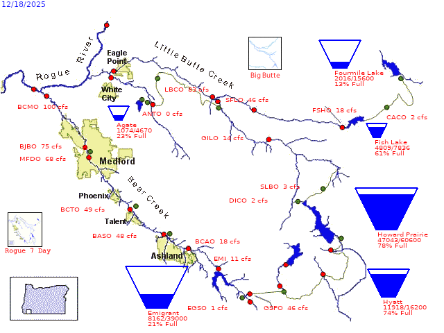
Average daily streamflows indicated in cubic feet per second.
Reservoir levels current as of midnight on date indicated.
Click on gaging stations (red dots) for streamflow hydrographs.


Key to Station Codes
Rogue River Basin Project Information
Grant's Pass Project Information